Louisiana Highway 1082
| ||||
|---|---|---|---|---|
 | ||||
| Route information | ||||
| Maintained by Louisiana DOTD | ||||
| Length: | 8.3 mi[1] (13.4 km) | |||
| Major junctions | ||||
| South end: |
| |||
| North end: |
| |||
| Location | ||||
| Parishes: | St. Tammany | |||
| Highway system | ||||
| ||||
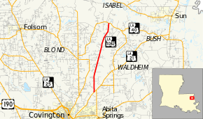
Louisiana Highway 1082 (LA 1082) is a state highway in Louisiana that serves St. Tammany Parish. It spans 8.3 miles (13.4 km) in a south to north direction. It is known locally as Old Military Road.
Route description
From the south, LA 1082 begins at an intersection with LA 21 (Military Road) north of Abita Springs. It heads north-northeastward to a terminus at LA 40 west of Bush.
LA 1082 is an undivided, two-lane roadway for its entire length.
Junction list
The entire highway is in St. Tammany Parish.
| Location | mi[1] | km | Destinations | Notes | |
|---|---|---|---|---|---|
| 0.0 | 0.0 | ||||
| 8.3 | 13.4 | ||||
| 1.000 mi = 1.609 km; 1.000 km = 0.621 mi | |||||
References
- ↑ 1.0 1.1 Google (February 12, 2015). "Louisiana Highway 1082" (Map). Google Maps. Google. Retrieved February 12, 2015.
External links
Route map: Bing
