Louisiana Highway 1040
| ||||
|---|---|---|---|---|
 | ||||
| Route information | ||||
| Maintained by Louisiana DOTD | ||||
| Length: | 6.0 mi[1] (9.7 km) | |||
| Existed: | 1955 renumbering – present | |||
| Major junctions | ||||
| West end: |
| |||
| East end: |
| |||
| Location | ||||
| Parishes: | Livingston, Tangipahoa | |||
| Highway system | ||||
| ||||
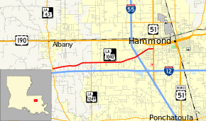
Louisiana Highway 1040 (LA 1040) is a state highway in Louisiana, is 6.0 miles (9.7 km) long and is also known as Old Baton Rouge Highway. In 2009, LA 1040's eastern terminus in Hammond was diverted to Chauvin Drive to resolve congestion problems at the intersection of Old Baton Rouge Highway and South Morrison Boulevard as that intersection is less than 100 feet (30 m) from the intersection of US 51 and US 190 (West Thomas Street).
Route description
From the east, LA 1040 begins at US 51 along Chauvin Drive (which assumes the trajectory of Corbin Road from east of South Morrison Boulevard). After about 1,200 feet (370 m) in which LA 1040 is a newly constructed two-way three-lane road (the center lane is for turns), LA 1040 is joined by Old Baton Rouge Highway and assumes its trajectory as LA 1040 bends left (westbound traffic on Old Baton Rouge Highway stops). LA 1040 bridges I-55 with no access by either road. At approximately the two-thirds point along its way from east to west, LA 1040 absorbs LA 1249 (Pumpkin Center Road) in a T-intersection just north of LA 1249's interchange with I-12. LA 1040 then bridges Natalbany River, enters Livingston Parish, and ends on LA 43 immediately north of LA 43's interchange with I-12.
LA 1040 provides an alternative for traffic between Hammond and points west of Hammond along I-12, in driving into or out of Hammond. With exception of the three-lane section along Chauvin Drive in Hammond, LA 1040 is a two-lane road.
History
As Old Baton Rouge Highway, LA 1040 was sidelined by Louisiana Highway 7 in Louisiana's state highways prior to 1955. Virtually all of the pre-1955 Louisiana Highway 7 either had been or ultimately was re-signed as US 190.[2]
Major intersections
| Parish | Location | mi[1] | km | Destinations | Notes |
|---|---|---|---|---|---|
| Livingston | 0.0 | 0.0 | |||
| Livingston– Tangipahoa line | 1.4 | 2.3 | Bridge over Natalbany River | ||
| Tangipahoa | 2.3 | 3.7 | Northern terminus of LA 1249 | ||
| Hammond | 6.0 | 9.7 | |||
| 1.000 mi = 1.609 km; 1.000 km = 0.621 mi | |||||
References
- ↑ 1.0 1.1 Google (February 11, 2015). "Louisiana Highway 1040" (Map). Google Maps. Google. Retrieved February 11, 2015.
- ↑ The stretch of the former Louisiana 7 from Ragley to the Texas state line was renumbered as LA 12 in 1955. It was part of the larger project called the Evangeline Highway and the even more ambitious Jefferson Davis Highway. See US 190 and Texas State Highway 12. The pre-1955 Louisiana Highway 7 should not be confused with the post-1955 Louisiana Highway 7, which was in northeastern Louisiana and which in the 1990s was entirely assimilated into the federal highway system as the Louisiana portion of US 371.
External links
Route map: Bing
