Lough Conn
| Lough Conn Loch Con | |
|---|---|
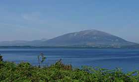
 Lough Conn with Nephin in the background | |
 | |
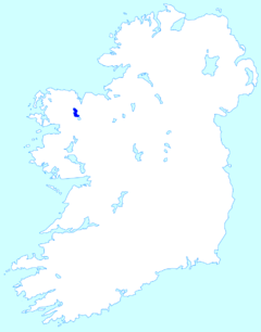
| Location | County Mayo |
| Coordinates | 54°02′36″N 9°14′42″W / 54.04333°N 9.24500°WCoordinates: 54°02′36″N 9°14′42″W / 54.04333°N 9.24500°W |
| Primary outflows | River Moy |
| Basin countries | Ireland |
| Surface area | 14,000 acres (57 km²) |
Lough Conn (Irish: Loch Con) is a lake in County Mayo, Ireland and covers about 14,000 acres (57 km²). With its immediate neighbour to the south, Lough Cullin, it is connected to the Atlantic by the River Moy. Lough Conn is noted for its trout and salmon fishing.
The ruins of an abbey exist at Errew.
Name
In Gaelic mythology, various accounts are given of the origin of the name.
In one account, Lough Conn was created when Fionn mac Cumhaill was hunting with his hounds; Conn and Cullin. They came across a wild boar. Finn and the hounds attempted to chase it. However, as the boar ran, water poured from its feet. The hounds ran ahead of Finn and evenally Conn was ahead of Cullin. Conn chased the boar for days until a lake appeared. The boar swam back to land but Conn was drowned. This happened again in the south to Cullin.
According to another account, the name means in Irish “the lake of the hounds”. The story is that the fierce hounds of the chieftain Modh pursued a wild pig into the lake, where they drowned.[1]
Location
The lake is connected to Lough Cullin by a channel that passes under the R310 regional road at Pontoon. The River Deel flows into Lough Conn and exits Lough Cullin at its southern end near Foxford, joining the River Moy which discharges into the Atlantic at Killala Bay.
References
- ↑ http://celt.ucc.ie/published/G106500C/index.html: The Metrical Dinnseanchas [placename lore] : Poem 74, Loch Con. English translation here: http://www.ucd.ie/tlh/trans/ws.rc.15.002.t.text.html
See also
- Ioseph of Loch Con
- List of loughs in Ireland