Los Antiguos
| Los Antiguos | |
|---|---|
| Town | |
 | |
 Los Antiguos Location in Argentina | |
| Coordinates: 46°32′50″S 71°37′50″W / 46.54722°S 71.63056°WCoordinates: 46°32′50″S 71°37′50″W / 46.54722°S 71.63056°W | |
| Country |
|
| Province | Santa Cruz |
| Department | Lago Buenos Aires |
| Population (2010 census [INDEC]) | |
| • Total | 3,363 |
| Area code(s) | +54 |
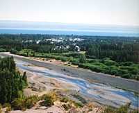
Los Antiguos is a town in Santa Cruz Province, Argentina, located on the south shore of Lago Buenos Aires. It lies 2 km from the border with Chile, and 8 km from the Chilean town of Chile Chico. It is connected to Perito Moreno and Caleta Olivia on the Atlantic coast by a paved road.
The town is an agricultural oasis, where small farms produce fruit crops. It was founded as the Leandro Alem Agricultural Colony in 1921, and was formally designated as a municipality in 1970. The area was covered by dust from the 1991 eruption of Mount Hudson, but it has since recovered.
The name of Los Antiguos is a translation of the Tehuelche name, I-Keu-khon, meaning "Place of the Elders."
In the 2001 census the town had a population of 2,047.[1]
Climate
Los Antiguos has a borderline semi-arid climate/Mediterranean climate (Köppen climate classification BSk/Csb) with warm, sunny summers and cold, snowy winters.
| Climate data for Los Antiguos | |||||||||||||
|---|---|---|---|---|---|---|---|---|---|---|---|---|---|
| Month | Jan | Feb | Mar | Apr | May | Jun | Jul | Aug | Sep | Oct | Nov | Dec | Year |
| Daily mean °C (°F) | 15.0 (59) |
14.6 (58.3) |
12.0 (53.6) |
8.6 (47.5) |
5.2 (41.4) |
2.6 (36.7) |
2.0 (35.6) |
3.5 (38.3) |
6.2 (43.2) |
9.1 (48.4) |
12.2 (54) |
14.1 (57.4) |
8.8 (47.8) |
| Average precipitation mm (inches) | 11.8 (0.465) |
6.9 (0.272) |
15.8 (0.622) |
24.7 (0.972) |
47.1 (1.854) |
40.1 (1.579) |
52.3 (2.059) |
38.9 (1.531) |
23.9 (0.941) |
13.1 (0.516) |
9.6 (0.378) |
10.2 (0.402) |
294.4 (11.591) |
| Avg. precipitation days | 2.2 | 1.9 | 3.2 | 5.1 | 6.7 | 6.3 | 6.6 | 5.8 | 4.5 | 3.7 | 2.8 | 3.2 | 52.0 |
| Average relative humidity (%) | 51.5 | 53.4 | 58.2 | 65.1 | 72.9 | 75.1 | 75.0 | 71.5 | 65.4 | 57.7 | 52.2 | 51.9 | 62.5 |
| Percent possible sunshine | 51.8 | 58.2 | 53.6 | 49.2 | 43.1 | 42.2 | 44.7 | 49.0 | 53.3 | 54.8 | 56.4 | 55.9 | 51.0 |
| Source: Weatherbase[2] | |||||||||||||
References
- ↑ INDEC website, Table 12.1
- ↑ "Weatherbase: Historical Weather for Los Antiguos". Weatherbase. Retrieved March 8, 2014.
External links
- Los Antiguos website (in Spanish)
- Lonely Planet
- Diarios de Los Antiguos