Los Angeles River bicycle path
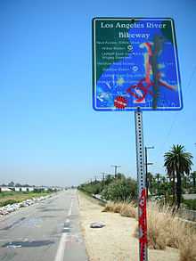
The Los Angeles River bicycle path (or L.A. River bicycle path) is, formally, a short bicycle path in the greater Los Angeles area, paralleling the Los Angeles River for approximately four miles as the river skirts the northern and eastern boundaries of Griffith Park in an area known as the Glendale Narrows.
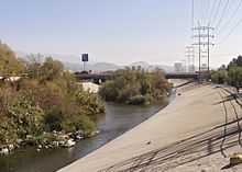
Following the Los Angeles Flood of 1938, concrete banks were created as a flood control measure for nearly all the length of the river, making it essentially navigable by bicycle to its end, where it empties into the San Pedro Bay in Long Beach. In recent years, the Friends of the Los Angeles River, a local civic and environmental group, have attempted to restore portions of the river as parkland in a manner that includes and encourages bicycle and pedestrian traffic, efforts realized in part as local Congressman Brad Sherman secured $460,000 in federal funds to extend the path north in the Sherman Oaks area.
Path Description
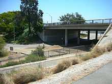
The LA river bicycle path consists of two separate sections that do not connect with each other except by city streets. The first and longest section begins in Long Beach at the mouth of the river up to Atlantic Blvd. in Vernon, southeast of Downtown Los Angeles. This segment, while looking very nice in most areas of the path itself, runs through some of the more dangerous sections of the greater Los Angeles Area. While most of the time there are no problems on the path, extra caution should be practiced when riding alone or at night. Access to the path in Long Beach is found where the riverbed intersects the following city streets: Pacific Coast Highway, Willow, Wardlow and Del Amo. In Long Beach, the bike path runs on the east side of the river bed. When the river intersects with Imperial Highway, bikers must exit the river path, cross the river over the roadway bridge,and re-enter the continuing bike path on the west side of the river. This is because the bike path on the East side of the river continues northeast onto the Rio Hondo and becomes a separate trail, heading on a different river. Mileage markers are painted on the pavement and signs are posted at regular intervals detailing upcoming city streets.
The second section of the river path begins near the cities of Burbank and Glendale at the river's intersection with Riverside Drive. Until recently, the path continued down the river to Fletcher Drive near the neighborhood of Silver Lake. However, as a result of the recent push by LA River environmentalist groups for more bike-friendly river uses, a new section of the path has opened. This new extension, continuing from Fletcher Drive south to where the Golden State Freeway (Interstate 5) runs over the river, has been paved and opened for pedestrian and bike use. It is not painted and marked as such yet, but all access gates are open and the path now has an underpass under all bridges and a clear end at a small park on Riverside Drive under the freeway.
The river still has no path between the Golden State Freeway and Atlantic Boulevard, or anywhere west of Riverside Drive in the San Fernando Valley except between Mason and Vanalden Avenues.
Future Development
On July 23, 2013 the nonprofit group Los Angeles River Revitalization Corp. announced a goal of completing a continuous 51-mile greenway and bike path along the river by the end of the decade.[1] The path is envisioned to be the central focus of a linear recreational park as well as providing an alternative transportation path through Los Angeles. The announcement by the nonprofit group precedes the expected August 30 release of a feasibility study being prepared by the U.S. Army Corps of Engineers. The Corps have the ultimate decision-making power over the river and it future revitalization.[2]
See also
References
- ↑ Christopher Hawthorne (2013-07-23). "Ambitious goal for L.A. River: Continuous 51-mile path by 2020". Los Angeles Times. Retrieved 2013-07-25.
- ↑ Christopher Hawthorne (2013-07-24). "L.A. River advocates wait for watershed Army Corps study". Los Angeles Times. Retrieved 2013-07-25.
External links
- Map to PCH Access Point, Southside of PCH underpass Long Beach
- Bike Paths of Los Angeles: L.A. River, Griffith Park
- Friends of the Los Angeles River
| ||||||
Coordinates: 33°47′24″N 118°12′14″W / 33.79011°N 118.20395°W