Lorrainville, Quebec
| Lorrainville | |
|---|---|
| Municipality | |
 | |
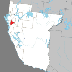 Location within Témiscamingue RCM. | |
 Lorrainville Location in western Quebec. | |
| Coordinates: 47°21′N 79°21′W / 47.350°N 79.350°WCoordinates: 47°21′N 79°21′W / 47.350°N 79.350°W[1] | |
| Country |
|
| Province |
|
| Region | Abitibi-Témiscamingue |
| RCM | Témiscamingue |
| Settled | 1883 |
| Constituted | February 16, 1994 |
| Government[2] | |
| • Mayor | Philippe Boutin |
| • Federal riding | Abitibi—Témiscamingue |
| • Prov. riding | Rouyn-Noranda–Témiscamingue |
| Area[2][3] | |
| • Total | 87.20 km2 (33.67 sq mi) |
| • Land | 88.12 km2 (34.02 sq mi) |
| There is an apparent contradiction between two authoritative sources | |
| Population (2011)[3] | |
| • Total | 1,272 |
| • Density | 14.4/km2 (37/sq mi) |
| • Pop (2006–11) |
|
| • Dwellings | 564 |
| Time zone | EST (UTC−5) |
| • Summer (DST) | EDT (UTC−4) |
| Postal code(s) | J0Z 2R0 |
| Area code(s) | 819 |
| Website |
www |
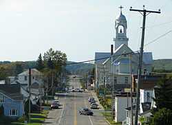
Lorrainville is a municipality in northwestern Quebec, Canada, in the Témiscamingue Regional County Municipality. It was founded in 1907 by Isaïe Douaire, who was a farmer from Ville Marie.
Demographics
Population trend:[4]
- Population in 2006: 1325 (2001 to 2006 population change: -6.1 %)
- Population in 2001: 1411
- Population in 1996: 1507
- Population in 1991: 1452
Private dwellings occupied by usual residents: 533 (total dwellings: 564)
Mother tongue:[5]
- English as first language: 0.7%
- French as first language: 94.4%
- English and French as first language: 0%
- Other as first language: 4.9%
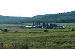
Countryside outside Lorrainville
See also
References
- ↑ Reference number 286579 of the Commission de toponymie du Québec (French)
- ↑ 2.0 2.1 "Lorrainville". Répertoire des municipalités (in French). Ministère des Affaires municipales, des Régions et de l'Occupation du territoire. Retrieved 2010-12-30.
- ↑ 3.0 3.1 "Lorrainville census profile". 2011 Census data. Statistics Canada. Retrieved 2010-12-30.
- ↑ Statistics Canada: 1996, 2001, 2006 census, and Population and dwelling count amendments
- ↑ "Lorrainville community profile". 2006 Census data. Statistics Canada. Retrieved 2010-12-30.
 |
Saint-Bruno-de-Guigues | Laverlochère | | |
| Duhamel-Ouest | |
Fugèreville | ||
| ||||
| | ||||
| Béarn |
| ||||||||||||||||||||||||||||||