Longa Island
| Location | |
|---|---|
 Longa Island Longa Island shown within Highland Scotland | |
| OS grid reference | NG736776 |
| Names | |
| Gaelic name | Longa |
| Norse name | Possibly Long-øy |
| Meaning of name | Old Norse 'ship Island' |
| Physical geography | |
| Island group | Highland |
| Area | 126 hectares (0.49 sq mi) |
| Area rank | 132 [1] |
| Highest elevation | Druim am Eilean 70 metres (230 ft) |
| Political geography | |
| Sovereign state | United Kingdom |
| Country | Scotland |
| Council area | Highland Council |
| Demographics | |
| Population | 0[2] |
| References | [3][4][5] |
Longa Island (Gaelic: Longa) is a small uninhabited island at the mouth of Gair Loch on the west coast of Scotland.
Geology
The island is mainly sandstone covered with grass and heather.[4]
Economy
There was a small fishing community in early in the 19th century; the island had become deserted by the latter part.
-
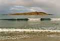
Longa Island, across the Caolas Beag
-
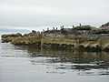
Shags on Sron na Caillich
-
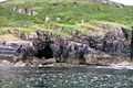
Unmapped Sea Cave Below An Raon
-
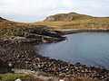
Camus na Rainich
Footnotes
- ↑ Area and population ranks: there are c. 300 islands >20ha in extent and 93 permanently inhabited islands were listed in the 2011 census.
- ↑ National Records of Scotland (15 August 2013) (pdf) Statistical Bulletin: 2011 Census: First Results on Population and Household Estimates for Scotland - Release 1C (Part Two). "Appendix 2: Population and households on Scotland’s inhabited islands". Retrieved 17 August 2013.
- ↑ Ordnance Survey. Get-a-map (Map). 1:25,000. Leisure. Ordinance Survey. Retrieved 21 August 2013.
- ↑ 4.0 4.1 Haswell-Smith, Hamish (2004). The Scottish Islands. Edinburgh: Canongate. ISBN 978-1-84195-454-7.
- ↑ Mac an Tàilleir, Iain (2003) Ainmean-àite/Placenames. (pdf) Pàrlamaid na h-Alba. Retrieved 26 August 2012.