London Defence Positions

The London Defence Positions were 19th century earthworks in the south-east of England, designed to protect London from foreign invasion landing on the south coast.
The 1859 Royal Commission on the Defence of the United Kingdom report on Britain's defences believed that London was practically undefendable; they proposed a fort at Shooters Hill to defend the Royal Arsenal at Woolwich, but it was never acted upon. Following a number of proposals by senior military figures based on simple earthworks for infantry and moveable armaments, the London Defence Scheme was announced in Parliament in March 1889. The London Defence Positions were to be earthworks to be thrown up in time of war, but backed up with permanent works which acted as stores and magazines, at 5 mile (8 km) intervals.
Locations
They were built along a 70-mile (113-kilometre) stretch of the North Downs from Guildford to the Darenth valley. Thirteen sites were chosen, at Pewley Hill, Henley Grove, Denbies, Box Hill, Betchworth, Reigate, East Merstham, Fosterdown, Woldingham, Betsom's Hill, Halstead, Farningham and (to the north of London) North Weald. The design of each site varied, but they were never very elaborate, just a magazine and storehouses for the mobilisation of troops, with limited defences. The intention was that the sites would, in addition to holding ammunition and other supplies, act as strong points in an almost continuous line of field fortifications.[1] The trench lines joining the Defence Positions could be rapidly excavated on the outbreak of war. Related stores were set up at Tilbury, Warley and possibly Caterham. They were quickly viewed as obsolete, and all were sold off in 1907, with the exception of Fort Halstead, now used by DSTL.
During World War I, part of the London Defence Positions scheme was resurrected to form a stop line of trenches, in case of a German invasion. North of the Thames, the line was continued to the River Lea at Broxbourne rather than stopping at Epping. South of the Thames, it was continued to Halling, via Wrotham, linking to the Chatham defences. At the western end the line was stopped short at Buckland Hill, just beyond Reigate Fort.[2]
At Guildford, houses have been built on the Pewley Hill site, but Henley Fort (aka Henley Grove) has been well preserved as a youth education centre. It could be seen on a Heritage Open Day.
Reigate Fort
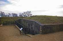
Reigate Fort has been owned by the National Trust since 1932. The structure was falling into disrepair, but grant money from the Biffaward, the Heritage Lottery grant and the National Trust itself has enabled the Trust to restore the building. The first phase of the repairs was carried out in 2000 and was funded by a grant of £104,000 from the Biffaward. A second phase cost £174,000.
The fort opened to the public free of charge in 2007, though restoration work is ongoing. Information boards have been installed to tell visitors about the buildings. A teacher's pack is available and educational visits can be arranged.[3]
See also
- Fortifications of London
- Outer London Defence Ring - the idea revived in World War II
References
- ↑ Hamilton-Baillie, J.R.E., Fort 2003 (Fortress Study Group), (31), pp6-40
- ↑ Victorian Forts and Artillery - The London Mobilisation Centres Alec Beanse and Roger Gill
- ↑ National Trust - Reigate Fort