Lom u Tachova
| Lom u Tachova | |||
|---|---|---|---|
| Municipality | |||
 | |||
| |||
 Lom u Tachova | |||
| Coordinates: 49°49′6″N 12°41′30″E / 49.81833°N 12.69167°ECoordinates: 49°49′6″N 12°41′30″E / 49.81833°N 12.69167°E | |||
| Country |
| ||
| Region | Plzeň | ||
| District | Tachov | ||
| Area | |||
| • Total | 8.43 km2 (3.25 sq mi) | ||
| Elevation | 500 m (1,600 ft) | ||
| Population (2011) | |||
| • Total | 415 | ||
| • Density | 49/km2 (130/sq mi) | ||
| Postal code | 347 01 | ||
| Website | http://www.lomutachova.cz | ||

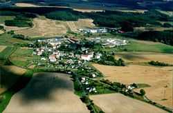
Lom u Tachova is a village and municipality (obec) in Tachov District in the Plzeň Region of the Czech Republic.
The municipality covers an area of 8.43 square kilometres (3.25 sq mi), and has a population of 406 (as at 28 August 2006).
Lom u Tachova lies approximately 6 kilometres (4 mi) east of Tachov, 50 km (31 mi) west of Plzeň, and 128 km (80 mi) west of Prague.
References
| Wikimedia Commons has media related to Lom u Tachova. |