Lohr a. Main
| Lohr a.Main | ||
|---|---|---|
| ||
 Lohr a.Main | ||
Location of Lohr a.Main within Main-Spessart district 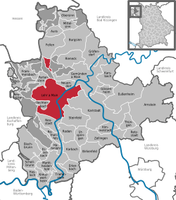 | ||
| Coordinates: 50°0′N 09°35′E / 50.000°N 9.583°ECoordinates: 50°0′N 09°35′E / 50.000°N 9.583°E | ||
| Country | Germany | |
| State | Bavaria | |
| Admin. region | Unterfranken | |
| District | Main-Spessart | |
| Government | ||
| • Mayor | Ernst-Heinrich Prüße (CSU) | |
| Area | ||
| • Total | 90.44 km2 (34.92 sq mi) | |
| Population (2013-12-31)[1] | ||
| • Total | 15,012 | |
| • Density | 170/km2 (430/sq mi) | |
| Time zone | CET/CEST (UTC+1/+2) | |
| Postal codes | 97816 | |
| Dialling codes | 09352 | |
| Vehicle registration | MSP | |

Lohr am Main (officially: Lohr a.Main) is a town in the Main-Spessart district in the Regierungsbezirk of Lower Franconia (Unterfranken) in Bavaria, Germany and the seat (but not a member) of the Verwaltungsgemeinschaft (Administrative Community) of Lohr am Main.
Geography
Location
The town lies on the Main in the Spessart (range) about halfway between Würzburg and Aschaffenburg in Lower Franconia. Lohr lies on the eastern slope of the Spessart at a bend in the river Main, which swings here towards the south, forming the beginning of the Mainviereck (“Main Square” – the southern part of the Spessart). In Lohr, the river Lohr empties into the Main. Perhaps for its geographical location or the fact that two major valleys lead into the interior of the range, the town is known as the “Gateway to the Spessart”.
The Main river valley is steep with an elevation change from 160 m above sea level at Gemünden dropping to 100 m above sea level at Hanau. The river Main in its natural state is a fast-moving stream unsuitable for shipping. In the 19th century the river was tamed and a system of dams and locks is now part of the Rhine-Main-Danube Canal connecting the North Sea with the Black Sea.
Geology
The bedrock, with a depth of about 400 m, is made up mainly of sedimentary minerals. In the Spessart is found a great deal of bunter. This geological plain with a slight slope to the southeast is the product of a large continental sea that drained owing to a tectonic shift. In the east the range is abutted by the Fränkische Platte (a flat, mostly agricultural region), whose geology is mainly Muschelkalk-based.
The sandstone bedrock with strata of loess and clay in conjunction with an extensive forest provide for excellent water quality of the springs and ground water of the region. The people of Lohr enjoy excellent drinking water. Currently large amounts of this water are pumped to areas as far away as Würzburg.
Constituent communities
Lohr am Main’s Stadtteile are Halsbach, Lindig, Pflochsbach, Rodenbach, Ruppertshütten, Sackenbach, Sendelbach, Steinbach and Wombach.
The town has the following Gemarkungen (traditional rural cadastral areas): Halsbach, Lohr a.Main, Pflochsbach, Rodenbach, Ruppertshütten, Sackenbach, Sendelbach, Steinbach, Wombach.
Moreover, the town of Lohr am Main also owns plots of land within other municipalities, namely Partenstein, Gemünden and Rechtenbach.
Neighbouring communities
Clockwise from the north, these are Partenstein, Frammersbach, Flörsbachtal, Fellen, Burgsinn, Rieneck, Neuendorf, Gemünden am Main, Karlstadt, Steinfeld, Neustadt am Main and Rechtenbach.
History
The town of Lohr am Main was settled no later than the 8th century, and by the time of its first documentary mention in 1295 it was already the main centre of the County of Rieneck. In 1333 Lohr was granted town rights, which can be explained by the disagreement about the inheritance of the Counts of Rieneck-Rothenfels, which had died out. Indeed, Lohr had been a “town” for quite some time already. The town lords were the Counts of Rieneck, who had been enfeoffed by the Archbishop of Mainz (evidence of this is only available beginning in 1366). In 1559, after the last Count of Rieneck, Philipp III’s death, the fief passed to the Archbishopric of Mainz. From 1603 to 1618, during the “Recatholization” many townsfolk fell victim to persecution as witches. The former Oberamt of the Prince-Bishopric of Würzburg was in favour of Prince Primate von Dalberg’s Principality of Aschaffenburg secularized and passed along with this state in 1814 (by this time it had become a department of the Grand Duchy of Frankfurt) to Bavaria. In the course of administrative reform in Bavaria, the current town-level municipality came into being with the Gemeindeedikt (“Municipal Edict”) of 1818. In 1875, the Old Main Bridge (Alte Mainbrücke) was built. In 1936 came the new Lindig neighbourhood. In 1939, Sendelbach was amalgamated with the town.
In National Socialist times between 1940 and 1945, more than 600 children, women and men were deported to the Nazi killing centres of Sonnenstein and Grafeneck, as well as to the Auschwitz and Mauthausen concentration camps from the then Health and Care Institute (now the Regional Hospital for Psychiatry) in the framework of the “Euthanasia” killing programme, Action T4. Since 1993, a bronze relief in the street by artist Rainer Stoltz has been a memorial to these victims of the National Socialist régime.
On 2 April 1945, Lohr citizen Dr. Karl Brand was murdered, because he wanted to surrender the town to American troops without a fight. Since 1979, a memorial stone has recalled this.[2]
From 1972 to 1978, the surrounding communities of Halsbach, Rodenbach, Ruppertshütten, Sackenbach, Steinbach, Wombach and Pflochsbach were amalgamated with the town. On 1 July 1972, the greater part of the District of Lohr (Landkreis Lohr) became part of the new District of Mittelmain (Landkreis Mittelmain), which in 1973 was given its current name, Main-Spessart. At first, Lohr am Main was chosen as the district seat (Kreisstadt), but in October 1972 it was decided that Karlstadt would be the new district seat, and the Landratsamt (district head’s office) was moved from Lohr to Karlstadt.
Culture and sightseeing
Museums
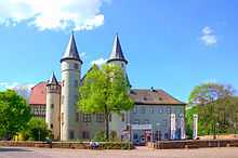
Housing the Spessartmuseum is the Lohrer Schloss. It deals mainly with economics and handicrafts, but also with the Spessart region’s history.
In the outlying centre of Sendelbach is an informative school museum with the foci “Imperial Germany” (1871-1918) and “Third Reich” (1933-1945).
Germany’s smallest museum is to be found on Haaggasse in a former transformer hut under monumental protection: Lothar Vormwald displays there all kinds of insulators.
Buildings
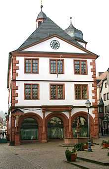
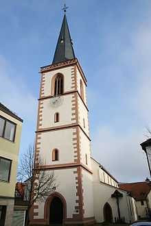
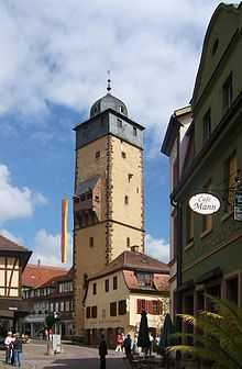
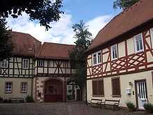
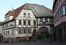
The most important sights are the Old Town Hall (1599-1602), the Lohrer Schloss (an Electoral Mainz palatial castle, 15th to 17th century), the Bayersturm (old town watchtower, 1330-1385), the parish church (12th to 15th century), remnants of the town’s fortifications, the historic Fischerviertel (“Fishermen’s Quarter”), the Franconian Old Town with many timber-frame buildings, the Mariabuchen Monastery and the Baroque Schloss and church in Steinbach.
Since 1875, the Alte Mainbrücke Lohr (“Lohr Old Main Bridge”) has spanned the river Main. One hundred years later, the 417 m-long Neue Mainbrücke Lohr (“Lohr New Main Bridge”), a prestressed-concrete structure, followed the old arch bridge.
Regular events
The Lohr Good Friday Procession each year draws thousands of visitors. Thirteen life-size figures mark the Way of the Cross. The figures are borne and overseen by members of the various craftsmen’s guilds. The Procession is actually a remnant of a once much greater, Baroque figure procession. It likely arose in the years after the Thirty Years' War. The earliest confirmed mention in the church records kept by Saint Michael’s parish comes from 1656.
Going back to a solemn vow made during the Plague in 1666 is the Lohr custom of holding a procession each year on Saint Roch’s Day (16 August) to the Valentinusberg (mountain) above the town and holding festive church services there in honour of the Holy Trinity.
Under the banner of Spessartsommer is grouped an array of summertime events such as Lohrer Tanzfest (dance festival), Altstadtfest (Old Town festival), City-Festival and Klingendes Lohr (“Ringing Lohr”).
Of particular importance is the Spessartfestwoche (“Spessart festival week”), which lasts ten days around 1 August. A Bavarian beer tent with seating for 4,500 and live music and a beergarden right on the Main with seating for a further 2,000 form the event’s centrepiece, while a midway with rides and closing fireworks round the event out. In 2008, the 63rd Spessartfestwoche was held. The Festwochen-Express bus service’s 12 special lines to and from the festival saw a ridership of 23,416.
There are also cabaret and amateur theatre events in Lohr and the outlying centres.
Coat of arms
The town’s arms might be described thus: Barry of ten gules and Or a bend wavy azure.
The town’s arms are essentially those borne by the Counts of Rieneck, who were the local lords from the 13th century until 1559. The wavy bend most likely refers to the Lohrbach, a local stream. The town’s oldest known seal, from 1408, already shows this design. Over time, the number of bars in the escutcheon has varied, as has the tincture of the bend (a version published in the 1920s, for instance, showed “Barry of nine gules and Or a bend wavy vert” – with nine bars and a green bend), for there was no proper blazon for the arms until 1957, when they were officially conferred on the town.[3]
Economy and infrastructure
Lohr am Main is economically the most important centre in the Main-Spessart district. Out of some 12,000 workers on the social welfare contribution rolls working in town, only some 5,500 actually live in Lohr. The greater number of roughly 6,200 workers commute each day to Lohr. If one compares Lohr am Main with the district seat of Karlstadt, Lohr’s importance stands out even more sharply. Although both towns have roughly the same population, Lohr am Main has a per-capita debt of only some €160 and about three times as many jobs. The great number of jobs and the big businesses in town are also reflected in the per-capita tax revenue. In 2005, this was about €1,000 for each inhabitant.
Established businesses
Important employers in Lohr are:
- Bosch Rexroth AG (hydraulics, engine building and automation technology) with 6,620 employees, including the former Indramat
- Bezirkskrankenhaus Lohr (hospital for psychiatry, psychotherapy and psychosomatic medicine) with 607 employees
- Gerresheimer Lohr GmbH (specialty glass and plastics) with 350 employees
- ATY Automotive & Industrial Components GmbH with 250 employees
- Nikolaus Sorg GmbH & Co KG (glass processing) with 165 employees
- Walter Hunger KG (hydraulic components) with 160 employees
- OWI Oskar Winkler GmbH & Co.KG (wooden and plastic mouldings) with 120 employees
- various wood-processing businesses
The town of Lohr am Main is, with its more than 4 000 ha of woodland, one of Bavaria’s biggest municipal forest owners. The town’s forest is a mixed broadleaf forest managed under the precepts of the Arbeitsgemeinschaft Naturgemäße Waldwirtschaft (ANW, “Natural Forest Management Working Group”). Since 2000, the town’s forest has been certified according to the Forest Stewardship Council’s (FSC) criteria.
Transport
Rail
The Main-Spessart Railway (Main-Spessart-Bahn) from Würzburg and Gemünden leaves the Main valley on the way to Aschaffenburg–Frankfurt am Main and crosses through the Spessart.
The Lohr–Wertheim line from Lohr station through the town was a single-track, unelectrified, standard-gauge line to Wertheim; passenger transport between Lohr-Town station and Wertheim was discontinued on 30 May 1976. The same happened on the rest of the line through town on 22 May 1977, although there is still goods transport. The former Lohr-Town station is now a pub beside the multi-storey parking garage and the bus station. It is called Stattbahnhof (a pun on its old name Stadtbahnhof, or “Town Station”; Stattbahnhof is pronounced the same way, but means “instead of station”).
A direct early InterCity service to Munich was replaced with a Regionalbahn to Würzburg when the Nuremberg–Munich high-speed railway came into service in 2006. The nearest InterCityExpress stops are Aschaffenburg and Würzburg.
On the eastern edge of town runs a short stretch of the Mühlbergtunnel on the Hanover-Würzburg high-speed rail line running north-south. Also within town limits runs a part of the Nantenbach Curve with the Schönraintunnel.
Road
Lohr lies on Bundesstraße 26, Bundesstraße 276, Staatsstraße (State Road) 2435 and Staatsstraße 2315. The nearest Autobahnen are the A 3 (Munich - Würzburg – Frankfurt) through the Weibersbrunn, Hösbach and Marktheidenfeld interchanges, and the A 7 (Würzburg - Kassel) through the Hammelburg interchange.
Waterway
The river Main is a Federal Waterway (Bundeswasserstraße) of the first order for which the Schweinfurt Water and Ship Transport Office (Wasser- und Schifffahrtsamt Schweinfurt) is responsible.
Public institutions
Lohr has at its disposal a Kreiskrankenhaus (District Hospital) with the disciplines of surgery, internal medicine, anaesthesiology, neurology, gynaecology, urology, ophthalmology and otolaryngology, and also the Bezirkskrankenhaus (Regional Hospital) for psychiatry, psychotherapy, psychosomatic medicine and forensic medicine for the Regierungsbezirk of Lower Franconia (Unterfranken).
Education
- Primary schools: Lohr am Main, Rodenbach, Sackenbach, Sendelbach, Wombach
- Special education schools: St. Kilian-Schule Sonderpädagogisches Förderzentrum Marktheidenfeld – Lohr; St. Nikolaus-Schule with emphasis on mental development
- Hauptschule: Gustav-Woehrnitz-Volksschule Lohr am Main
- Realschule: Georg-Ludwig-Rexroth-Realschule
- Gymnasium: Franz-Ludwig-von-Erthal-Gymnasium
- Vocational school: Staatliche Berufsschule Main-Spessart with professional school and training centre
- Professional school - Berufsfachschule für Krankenpflege (nursing)
- Forest school: Bayerische Forstschule
- Forest management school: Bayerische Technikerschule für Waldwirtschaft
- IGM education centre
- music school: municipal singing and music school
- Folk high school: Volkshochschule der Stadt Lohr am Main
Famous people
Sons and daughters of the town
- Franz Christoph von Hutten (1706–1770), Bishop of Speyer (born in Steinbach)
- Franz Ludwig von Erthal (1730–1795), Bishop of Bamberg and Würzburg
- Franz Anton Brendel (4 October 1735 – 23 May 1799 in Strasbourg), constitutional (not authorized by the Church) Bishop of Strasbourg during the French Revolution
- Franz Jakob Kreuter (1813–1899), German architect and building engineer.
- Joseph Koeth (1870–1936), politician and Reich minister in the Weimar Republic
- Georg Ludwig Rexroth (1902–1992), entrepreneur and benefactor
- Katrine von Hutten (1944–2013), writer and translator
- Hermann Joha (1960– ), stuntman and director of the stunt production firm action concept (Der Clown and Alarm für Cobra 11)
- Achim Greser (1961– ), caricaturist
- Nadine Angerer (1978– ), football world champion 2007
- Maria Sophia Margaretha Catherina von Erthal (1725-1796), sister of Franz Ludwig von Erthal, conjectured to have been the real-life model for Snow White.
International relations
Twin towns – Sister cities
Lohr am Main is twinned with:
 Ouistreham, Calvados, France[4]
 Burgeis, South Tyrol, Italy
 Milicz, Lower Silesia, Poland
Sponsorship
 Přísečnice, Czech Republic
In 1956 the town undertook the sponsorship arrangement for Sudeten Germans driven out of their homeland in the town and district known in German as Preßnitz. The town itself no longer exists. In 1974, its former site became the bed of a new reservoir.
Other
- Lohr is said to be Snow White’s possible birthplace.
- In Lohr the club Bürgernetz Mainspessart e. V. is operating its technology for Europe’s biggest interconnected WaveLan network. The so-called Wavelink broadcast network will be offered all club members living between Gemünden and Erlach.
- Native-born Lohrers are known as Mopper, while those who have come to live in town are Schnüdel.
Further reading
- Günter Christ: Lohr am Main. Der ehemalige Landkreis. Hrsg. von der Kommission für Bayerische Landesgeschichte bei der Bayerischen Akademie der Wissenschaften. Laßleben, Kallmünz 2007, ISBN 978-3-7696-6854-4
- Werner Loibl: Die kurmainzische Spiegelmanufaktur Lohr am Main (1698–1806) und die Nachfolgebetriebe im Spessart, 3 Bände. Geschichts- und Kunstverein Aschaffenburg, Aschaffenburg 2012. ISBN 978-3-87965-116-0, ISBN 978-3-87965-117-7, ISBN 978-3-87965-118-4
- Ruf, Alfons, Die Pfarrkirche St. Michael in Lohr und ihre Baugeschichte. Lohr a. Main, 1983.
- Ruf, Theodor, Quellen und Erläuterungen zur Geschichte der Lohr am Main bis zum Jahre 1559, Lohr a.Main, 2011. ISBN 978-3-035963-7
- Ruf, Theodor: Die Grafen von Rieneck. Genealogie und Territorienbildung. Würzburg 1984 (town history)
References
- ↑ "Fortschreibung des Bevölkerungsstandes". Bayerisches Landesamt für Statistik und Datenverarbeitung (in German). 31 December 2013.
- ↑ Gedenkstätten für die Opfer des Nationalsozialismus. Eine Dokumentation, Band 1. Bundeszentrale für politische Bildung, Bonn 1995, ISBN 3-89331-208-0, S. 161
- ↑ Description/explanation of Lohr’s coat of arms at Heraldry of the World
- ↑ "National Commission for Decentralised cooperation". Délégation pour l’Action Extérieure des Collectivités Territoriales (Ministère des Affaires étrangères) (in French). Retrieved 2013-12-26.
External links
| Wikimedia Commons has media related to Lohr am Main. |
- Lohr. article in: Meyers Konversations-Lexikon, 4. Aufl. 1888–1890, Bd. 10, S. 875 f.
- Town’s official webpage (German)
- `Die Menschen in Lohr´ (German)
- Lohr am Main at DMOZ
- Handball in Lohr (German)