Logan Township, Pike County, Indiana
| Logan Township Pike County | |
|---|---|
| Township | |
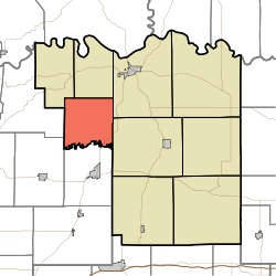 Location in Pike County | |
| Coordinates: 38°25′01″N 87°21′33″W / 38.41694°N 87.35917°WCoordinates: 38°25′01″N 87°21′33″W / 38.41694°N 87.35917°W | |
| Country |
|
| State |
|
| County | Pike |
| Government | |
| • Type | Indiana township |
| Area | |
| • Total | 24.31 sq mi (63.0 km2) |
| • Land | 23.94 sq mi (62.0 km2) |
| • Water | 0.37 sq mi (1.0 km2) 1.52% |
| Elevation | 446 ft (136 m) |
| Population (2010) | |
| • Total | 474 |
| • Density | 19.8/sq mi (7.6/km2) |
| ZIP codes | 47567, 47598 |
| GNIS feature ID | 0453580 |
Logan Township is one of nine townships in Pike County, Indiana, United States. As of the 2010 census, its population was 474 and it contained 175 housing units.[1]
Geography
According to the 2010 census, the township has a total area of 24.31 square miles (63.0 km2), of which 23.94 square miles (62.0 km2) (or 98.48%) is land and 0.37 square miles (0.96 km2) (or 1.52%) is water.[1] The Patoka River defines the township's southern border.
Unincorporated towns
- Chandler at 38°25′17″N 87°21′08″W / 38.421437°N 87.352237°W
- Coats Spring at 38°26′15″N 87°23′26″W / 38.437548°N 87.390572°W
- Rumble at 38°26′09″N 87°20′34″W / 38.435882°N 87.342793°W
(This list is based on USGS data and may include former settlements.)
Cemeteries
The township contains these seven cemeteries: Barnes, Beck, DeJarnett, Loveless, McGillem, Willis and Wilson.
Major highways
-
 I-69
I-69 -
 SR 57
SR 57
School districts
- Pike County School Corporation
Political districts
- State House District 64
- State Senate District 48
References
- "Logan Township, Pike County, Indiana". Geographic Names Information System. United States Geological Survey. Retrieved 2009-11-26.
- United States Census Bureau 2009 TIGER/Line Shapefiles
- IndianaMap
- ↑ 1.0 1.1 "Population, Housing Units, Area, and Density: 2010 - County -- County Subdivision and Place -- 2010 Census Summary File 1". United States Census. Retrieved 2013-05-10.
External links
- Indiana Township Association
- United Township Association of Indiana
- City-Data.com page for Logan Township
 |
Clay Township | Madison Township | Washington Township | |
| Washington Township, Gibson County | |
Patoka Township | ||
| ||||
| | ||||
| Center Township, Gibson County | Columbia Township, Gibson County |
| |||||||||||||||||||||||||||||