Logan Square Boulevards Historic District
|
Logan Square Boulevards Historic District | |
|
Chicago Landmark | |
 | |
 | |
| Location | W. Logan Blvd., Logan Sq., N. Kedzie Blvd., Palmer Sq., and N. Humboldt Blvd., Chicago, Illinois |
|---|---|
| Coordinates | 41°55′42″N 87°42′25″W / 41.92833°N 87.70694°WCoordinates: 41°55′42″N 87°42′25″W / 41.92833°N 87.70694°W |
| Area | 265 acres (107 ha) |
| Governing body | Local |
| NRHP Reference # | 85002901[1] |
| Significant dates | |
| Added to NRHP | November 20, 1985 |
| Designated CL | November 1, 2005 |
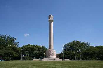
The Logan Square Boulevards Historic District is a linear historic district in Chicago's Logan Square community area which encompasses 2.5 miles (4.0 km) of the city's boulevard system. The district includes sections of Logan Boulevard, Kedzie Avenue, and Humboldt Boulevard; it also includes two parks, Logan Square and Palmer Square, which connect the boulevards. Grassy medians run down the center of the boulevards; the medians and the two squares both provided recreational areas for residents and drew development to the area. Logan Square also includes the Illinois Centennial Monument, which was erected in 1918 to celebrate Illinois' centennial. The boulevards pass through residential areas and are lined with homes in a variety of architectural styles; some of the most common designs are sandstone Romanesque houses, gray stone Victorian houses, and brick buildings with Tudor Revival and Prairie School designs.[2]
The district was added to the National Register of Historic Places on November 20, 1985.[1] It was named a Chicago Landmark on November 1, 2005.[3]
References
- ↑ 1.0 1.1 "National Register Information System". National Register of Historic Places. National Park Service. 2010-07-09.
- ↑ Bluestone, Daniel M. (July 1985). "National Register of Historic Places Inventory - Nomination Form: Logan Square Boulevards Historic District". National Park Service. Retrieved March 17, 2014.
- ↑ "Logan Square Boulevards District". Chicago Landmarks. City of Chicago. Retrieved March 17, 2014.
| ||||||||||||||||||||||||||