Logan, Arkansas
| Logan, Arkansas | |
|---|---|
| Unincorporated community | |
 Logan, Arkansas | |
| Coordinates: 36°12′03″N 94°23′15″W / 36.20083°N 94.38750°WCoordinates: 36°12′03″N 94°23′15″W / 36.20083°N 94.38750°W | |
| Country | United States |
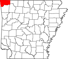
| State | Arkansas |
| County | Benton |
| Elevation | 1,043 ft (318 m) |
| Time zone | Central (CST) (UTC-6) |
| • Summer (DST) | CDT (UTC-5) |
| Area code(s) | 479 |
| GNIS feature ID | 72443[1] |
Logan is an unincorporated community in Benton County, Arkansas, United States. Logan is 15.5 miles (24.9 km) southwest of Bentonville. The Gailey Hollow Farmstead and the McIntyre House, both listed on the National Register of Historic Places, are near Logan.[2]
References
- ↑ "Logan". Geographic Names Information System. United States Geological Survey.
- ↑ "National Register Information System". National Register of Historic Places. National Park Service. 2010-07-09.
| |||||||||||||||||||||||||||||||||||||