Locust Creek Covered Bridge State Historic Site
| Locust Creek Covered Bridge State Historic Site | |
| Missouri State Historic Site | |
 | |
| Area | 0.05 sq mi (0 km2) |
|---|---|
| Founded | 1968 |
| Website: http://mostateparks.com/locustbridge.htm | |
 | |
| Nearest city | Laclede, Missouri |
|---|---|
| Coordinates | 39°47′30″N 93°14′3″W / 39.79167°N 93.23417°WCoordinates: 39°47′30″N 93°14′3″W / 39.79167°N 93.23417°W |
| Built | 1868 |
| Architect | Bishop & Eaton |
| Governing body | State |
| NRHP Reference # | 70000340[1] |
| Added to NRHP | May 19, 1970 |
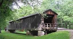
Locust Creek Covered Bridge State Historic Site in Linn County, Missouri, is maintained by the Missouri Department of Natural Resources as a state historic site. Also called the Linn County Bridge, the site is located about 3 miles (4.8 km) west of Laclede. The bridge is listed on the National Register of Historic Places. At a length of 151 feet (46 m) with a width of 16 ft 8 in (5.08 m) it is the longest remaining covered bridge in the state.[2]
History
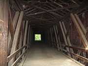
In August 1868, a contract was awarded by the Linn County Commissioners to Bishop & Eaton for a bridge across Locust Creek, with the cost not to exceed 5,000 dollars.[3] The structure is a Howe truss, constructed of white pine. Vertical iron rods tightly secure diagonal wooden beams to the bottom and top of the structure.[4] In addition to its utilitarian function, over time the bridge was a hangout for locals with some proclaiming their love for one another and their presence at the bridge with carvings along the bridge's internal walls. The bridge over Locust Creek also proved a popular fishing spot for at least one Linn County boy. John J. Pershing, later one of America's most famous military leaders, grew up in nearby Laclede and often fished and swam at the bridge.[4] Not far from the bridge is the Gen. John J. Pershing Boyhood Home State Historic Site as well as Pershing State Park.
At first used only for wagon, horse, and pedestrian traffic, in the early 20th century the bridge would become a vital automotive link across northern Missouri, Route 8.[4] However the age and narrow width made the bridge unsuitable for heavy vehicle traffic after a period and the bridge was bypassed with the completion of U.S. Route 36 in 1930. The bridge also runs parallel to the Hannibal and St. Joseph Railroad. After World War II, the course of Locust Creek was changed and the bridge spanned a dry creek bed.[5][4] Over time the creek bed filled with silt, leaving the bridge resting on mud much of the time.
In 1968, the State of Missouri acquired the bridge and established the Locust Creek Covered Bridge State Historic Site, then repaired the bridge, replacing its roof, sheeting, and flooring.[4] The bridge was added to the National Register of Historic Places in 1970.[1] The Missouri Department of Conservation undertook another major improvement in 1991, raising the bridge by six feet to protect the wooden frame and flooring from the marshy ground.[4] The bridge site is open daily from sunrise to sunset. An informational kiosk is available to provide information about the bridge and its history. The site is managed from nearby Pershing State Park.
References
- ↑ 1.0 1.1 "National Register Information System". National Register of Historic Places. National Park Service. 2008-04-15.
- ↑ Covered Bridges; Missouri Dept of Natural Resources, Jefferson City, MO
- ↑ Covered Bridges; Missouri Dept of Natural Resources, Jefferson City, MO
- ↑ 4.0 4.1 4.2 4.3 4.4 4.5 "Locust Creek Covered Bridge State Historic Site". Missouri Department of Natural Resources. 2012. Retrieved 30 November 2012.
- ↑ Earngey, Bill. Missouri Roadsides. University of Missouri Press. p. 150. ISBN 978-0-8262-1021-0.
External links
- Locust Creek Covered Bridge State Historic Site.
- Locust Creek Covered Bridge, Historic Bridges of the United States at bridgehunter.com
- Locust Creek Covered Bridge at RootsWeb.com
See also
| ||||||||||||||||||||||||||