Lock and Dam No. 24
 Mississippi River Lock and Dam number 24 | |
| Location | Belleview Precinct, Calhoun County, Illinois / Clarksville, Missouri, USA |
|---|---|
| Coordinates | 39°22′36″N 90°54′30″W / 39.37667°N 90.90833°W |
| Construction began | July 1936 |
| Opening date | March 12, 1940 |
| Operator(s) | United States Army Corps of Engineers |
| Dam and spillways | |
| Impounds | Upper Mississippi River |
| Length | 1,340 feet (408.4 m) |
| Reservoir | |
| Creates | Pool 24 |
| Total capacity | 125,363 acre·ft (0.154633 km3) |
| Catchment area | 140,900 sq mi (365,000 km2) |
|
Lock and Dam No. 24 Historic District | |
| Location | 350 N. First St., Clarksville, Missouri |
| Area | 102.7 acres (41.6 ha) |
| Built | 1940 |
| Governing body | Federal |
| MPS | Upper Mississippi River 9-Foot Navigation Project MPS |
| NRHP Reference # | 04000183[1] |
| Added to NRHP | March 10, 2004 |
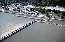
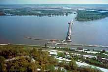
Lock and Dam No. 24 is a lock and dam located near Clarksville, Missouri around river mile 273.4 on the Upper Mississippi River. The main lock is 110 feet (33.5 m) wide and 600 feet (182.9 m) long with its bottom at an elevation of 430 feet. The auxiliary lock is not operational. Normal pool elevation behind the dam is 449 feet. The movable portion of the dam is 1,340 feet (408.4 m) long and consists of 15 submersible, elliptical, tainter gates. A 2,720 feet (829.1 m) submersible earthen dike extends from the movable dam to the Illinois shore. In 2004, the facility was listed in the National Register of Historic Places as Lock and Dam No. 24 Historic District, #04000183 covering 1,027 acres (4.2 km2), 3 buildings, 15 structures, 4 objects.
References
- ↑ "National Register Information System". National Register of Historic Places. National Park Service. 2010-07-09.
See also
External links
- Clarksville Visitor center, near the lock and dam with additional dimensions of the dam
- Lock 24
- Upper Mississippi River Nine-Foot Channel Project, Lock & Dam No. 24, Clarksville, Pike County, MO
| Locks and dams of the Upper Mississippi River | ||
|---|---|---|
| Upstream: Lock and Dam No. 22 |
Downstream: Lock and Dam No. 25 | |
| ||||||||||||||||||||||||||
Coordinates: 39°22′36″N 90°54′30″W / 39.37667°N 90.90833°W