Local government areas of Queensland

Map of LGAs
This is a list of local government areas (LGAs) in Queensland, sorted by region. For the history and responsibilities of local government in that state, see Local government in Queensland.
LGAs sorted by region
| Name |
Council seat |
Region |
Year Estab. |
Area (km²) |
Pop'n (2006) |
Notes |
Map |
|---|---|---|---|---|---|---|---|
| Brisbane, City ofCity of Brisbane | Brisbane | South East Queensland | 1924 | 1,367 | 956,129 | Capital city of Queensland Administers the central portion of the South East Queensland agglomeration |
 |
| Gold Coast City, Gold Coast City | Surfers Paradise | South East Queensland | 1948 | 1,358 | 455,419 |  | |
| Ipswich, City ofCity of Ipswich | Ipswich | South East Queensland | 1860 | 1,089 | 142,525 |  | |
| Lockyer Valley Region, Lockyer Valley Region | Gatton | South East Queensland | 2008 | 2,273 | 31,138 |  | |
| Logan City, Logan City | Logan Central | South East Queensland | 1978 | 913 | 253,864 |  | |
| Moreton Bay Region, Moreton Bay Region | Strathpine | South East Queensland | 2008 | 2,011 | 337,846 | Amalgamation of City of Redcliffe and the shires of Pine Rivers and Caboolture. |  |
| Redland City, Redland City | Cleveland | South East Queensland | 1949 | 537 | 126,964 |  | |
| Scenic Rim Region, Scenic Rim Region | Beaudesert | South East Queensland | 2008 | 4,256 | 34,659 |  | |
| Somerset Region, Somerset Region | Esk | South East Queensland | 2008 | 5,379 | 19,291 |  | |
| Sunshine Coast Region, Sunshine Coast Region | Nambour | South East Queensland | 3,126 | 290,026 |  | ||
| Banana, Shire ofShire of Banana | Biloela | Wide Bay-Burnett | 1879 | 28,577 | 15,773 |  | |
| Bundaberg Region, Bundaberg Region | Bundaberg | Wide Bay-Burnett | 2008 | 6,451 | 86,364 |  | |
| Cherbourg, Aboriginal Shire ofAboriginal Shire of Cherbourg | Cherbourg | Wide Bay-Burnett | 1986 | 32 | 1,250 | ||
| Fraser Coast Region, Fraser Coast Region | Hervey Bay | Wide Bay-Burnett | 2008 | 7,125 | 86,747 |  | |
| Gympie Region, Gympie Region | Gympie | Wide Bay-Burnett | 2008 | 6,898 | 42,820 | On 15 March 2008, the Shire of Cooloola merged with the Shire of Kilkivan and Division 3 (Theebine/Gunalda areas) of Shire of Tiaro to form the Gympie Region.[1] |  |
| North Burnett Region, North Burnett Region | Gayndah | Wide Bay-Burnett | 2008 | 19,708 | 10,668 | 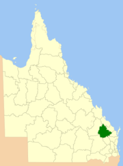 | |
| South Burnett Region, South Burnett Region | Kingaroy | Wide Bay-Burnett | 2008 | 8,399 | 29,734 | 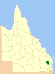 | |
| Goondiwindi Region, Goondiwindi Region | Goondiwindi | Darling Downs | 2008 | 19,294 | 10,720 | 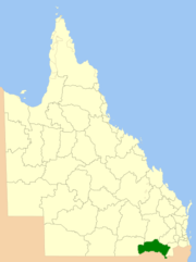 | |
| Southern Downs Region, Southern Downs Region | Warwick | Darling Downs | 2008 | 7,120 | 32,610 | 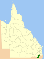 | |
| Toowoomba Region, Toowoomba Region | Toowoomba | Darling Downs | 2008 | 12,973 | 151,283 |  | |
| Western Downs Region, Western Downs Region | Dalby | Darling Downs | 2008 | 38,039 | 30,018 | 2008 Amalgamation of Town of Dalby, Shire of Chinchilla, Shire of Murilla, Shire of Tara, Shire of Wambo and Division 2 of Shire of Taroom to form the Dalby Region. Renamed Western Downs Region in August 2009. |  |
| Central Highlands Region, Central Highlands Region | Emerald | Central Queensland | 2008 | 59,884 | 26,824 |  | |
| Gladstone Region, Gladstone Region | Gladstone | Central Queensland | 2008 | 10,488 | 51,351 |  | |
| Isaac Region, Isaac Region | Clermont | Central Queensland | 2008 | 58,862 | 20,443 |  | |
| Mackay Region, Mackay Region | Mackay | Central Queensland | 2008 | 7,621 | 100,260 |  | |
| Rockhampton Region, Rockhampton Region | Rockhampton | Central Queensland | 2008 | 18,361 | 103,297 |  | |
| Woorabinda, Aboriginal Shire ofAboriginal Shire of Woorabinda | Woorabinda | Central Queensland | 1986 | 391 | 1,035 | ||
| Burdekin, Shire ofShire of Burdekin | Ayr | North Queensland | 1888 | 5,052 | 17,020 |  | |
| Charters Towers Region, Charters Towers Region | Charters Towers | North Queensland | 2008 | 68,388 | 12,280 |  | |
| Hinchinbrook, Shire ofShire of Hinchinbrook | Ingham | North Queensland | 1879 | 2,811 | 12,260 |  | |
| Palm Island, Aboriginal Shire ofAboriginal Shire of Palm Island | Palm Island | North Queensland | 1986 | 71 | 1,984 |  | |
| Townsville, City ofCity of Townsville | Townsville | North Queensland | 2008 | 3,733 | 164,008 |  | |
| Whitsunday Region, Whitsunday Region | Bowen | North Queensland | 2008 | 23,856 | 30,719 |  | |
| Aurukun, Shire ofShire of Aurukun | Aurukun | Far North Queensland | 1978 | 7,375 | 1,044 |  | |
| Cairns Region, Cairns Region | Cairns | Far North Queensland | 2008 | 4,128 | 142,723 |  | |
| Cassowary Coast Region, Cassowary Coast Region | Innisfail | Far North Queensland | 2008 | 4,701 | 30,843 |  | |
| Cook, Shire ofShire of Cook | Cooktown | Far North Queensland | 1919 | 106,188 | 3,464 |  | |
| Hopevale, Hopevale | Hopevale | Far North Queensland | 1986 | 1,118 | 914 | ||
| Kowanyama, Aboriginal Shire ofAboriginal Shire of Kowanyama | Kowanyama | Far North Queensland | 1987 | 2,576 | 1,021 |  | |
| Lockhart River, Lockhart River | Lockhart River | Far North Queensland | 1987 | 3,545 | 642 | ||
| Mapoon Aboriginal Shire, Mapoon Aboriginal Shire | Mapoon | Far North Queensland | 2002 | 530 | 214 | ||
| Napranum Aboriginal Shire, Napranum Aboriginal Shire | Napranum | Far North Queensland | 1989 | 1,995 | 813 | ||
| Northern Peninsula Area Region, Northern Peninsula Area Region | Bamaga | Far North Queensland | 2008 | 1,030 | 2,175 | ||
| Pormpuraaw, Aboriginal Shire ofAboriginal Shire of Pormpuraaw | Pormpuraaw | Far North Queensland | 1987 | 4,433 | 600 |  | |
| Tablelands Region, Tablelands Region | Malanda | Far North Queensland | 2008 | 64,999 | 42,145 |  | |
| Torres, Shire ofShire of Torres | Thursday Island | Far North Queensland | 1974 | 886 | 3,233 | ||
| Torres Strait Island Region, Torres Strait Island Region | Thursday Island | Far North Queensland | 2008 | 489 | 4,434 | ||
| Weipa, Weipa | Weipa | Far North Queensland | 1963 | 10.9 | 2,830 | Administered under own Act by Rio Tinto Alcan | |
| Wujal Wujal Aboriginal Shire, Wujal Wujal Aboriginal Shire | Wujal Wujal | Far North Queensland | 1987 | 11 | 379 | ||
| Yarrabah, Aboriginal Shire ofAboriginal Shire of Yarrabah | Yarrabah | Far North Queensland | 1986 | 158 | 2,322 |  | |
| Burke, Shire ofShire of Burke | Burketown | North West | 1885 | 40,126 | 481 |  | |
| Carpentaria, Shire ofShire of Carpentaria | Normanton | North West | 1883 | 64,373 | 2,290 |  | |
| Cloncurry, Shire ofShire of Cloncurry | Cloncurry | North West | 1884 | 48,113 | 3,834 | 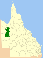 | |
| Croydon, Shire ofShire of Croydon | Croydon | North West | 1887 | 29,578 | 319 |  | |
| Doomadgee, Aboriginal Shire ofAboriginal Shire of Doomadgee | Doomadgee | North West | 1987 | 1,862 | 1,236 |  | |
| Etheridge, Shire ofShire of Etheridge | Georgetown | North West | 1882 | 39,332 | 851 |  | |
| Flinders, Shire ofShire of Flinders | Hughenden | North West | 1882 | 41,538 | 1,974 |  | |
| McKinlay, Shire ofShire of McKinlay | Julia Creek | North West | 1891 | 40,880 | 1,013 |  | |
| Mornington, Shire ofShire of Mornington | Gununa | North West | 1978 | 1,232 | 1,044 | ||
| Mount Isa, City ofCity of Mount Isa | Mount Isa | North West | 1914 | 43,349 | 21,201 |  | |
| Richmond, Shire ofShire of Richmond | Richmond | North West | 1910 | 26,602 | 1,148 |  | |
| Barcaldine Region, Barcaldine Region | Barcaldine | Central West | 2008 | 53,677 | 3,503 |  | |
| Barcoo, Shire ofShire of Barcoo | Jundah | Central West | 1885 | 62,001 | 450 |  | |
| Blackall-Tambo Region, Blackall-Tambo Region | Blackall | Central West | 2008 | 30,451 | 2,069 |  | |
| Boulia, Shire ofShire of Boulia | Boulia | Central West | 1887 | 61,102 | 547 | 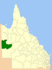 | |
| Diamantina, Shire ofShire of Diamantina | Bedourie | Central West | 1879 | 94,823 | 304 |  | |
| Longreach Region, Longreach Region | Longreach | Central West | 2008 | 40,638 | 4,664 |  | |
| Winton, Shire ofShire of Winton | Winton | Central West | 1886 | 53,935 | 1,544 |  | |
| Balonne, Shire ofShire of Balonne | St George | South West | 1883 | 31,150 | 5,627 |  | |
| Bulloo, Shire ofShire of Bulloo | Thargomindah | South West | 1880 | 73,807 | 457 |  | |
| Maranoa Region, Maranoa Region | Roma | South West | 2008 | 58,830 | 12,648 | Renamed from Roma in June 2009 |  |
| Murweh, Shire ofShire of Murweh | Charleville | South West | 1879 | 40,742 | 5,026 |  | |
| Paroo, Shire ofShire of Paroo | Cunnamulla | South West | 1879 | 47,714 | 2,114 |  | |
| Quilpie, Shire ofShire of Quilpie | Quilpie | South West | 1930 | 67,633 | 1,049 |  |
See also
References
- ↑ "Agency ID11054, Gympie Regional Council". Queensland State Archives. Retrieved 9 September 2013.
External links
- Shires of Australia at statoids.com
- "Local Government Association of Queensland". Local Government Association of Queensland. Retrieved 5 May 2011.
| ||||||||||||||||||||||||||||||||||||||
| |||||||||||||||||||||