Lobata District
| Lobata | |
|---|---|
| District | |
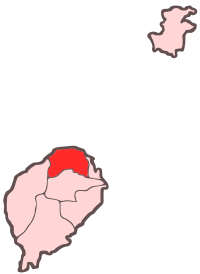 Location within São Tomé and Príncipe | |
| Coordinates: 0°22′N 6°40′E / 0.367°N 6.667°ECoordinates: 0°22′N 6°40′E / 0.367°N 6.667°E | |
| Country | São Tomé and Príncipe |
| Province/Island | São Tomé |
| Seat | Guadalupe |
| Area | |
| • Total | 105 km2 (41 sq mi) |
| Population (2011 census) | |
| • Total | 20,007 |
| • Density | 190/km2 (490/sq mi) |
| Time zone | UTC (UTC+0) |
Lobata is a district of São Tomé Province. Out of the seven districts that make up the equatorial Atlantic islands of São Tomé and Príncipe, it is third largest in terms of population with approximately 16,500 residents and covers approximately 105 square kilometers. The district capital is Guadalupe. The municipality includes an islet called the Ilhéu das Cabras.
District Population History
- 1940 9,240 (15.2% of the national population)
- 1950 8,190 (13.6% of the national population)
- 1960 7,875 (12.3% of the national population)
- 1970 9,361 (12.7% of the national population)
- 1981 11,776 (12.2% of the national population)
- 1991 14,173 (12.1% of the national population)
- 2001 15,187 (11.0% of the national population)
Other
Lobata has schools or collegiates (colegio), a lyceum (middle schools), a stadium, churches, beaches, a small port and a few squares (praças). The municipality is the middle-class in GDP and GNP in São Tomé and Príncipe.
| North: Atlantic Ocean | ||
| West: Lembá | Lobata | East: Água Grande |
| South: Mé-Zóchi |
Twin towns - Sister cities
 Vila Nova de Famalicão, Portugal - 2013
| ||||||||||||