Llyn y Fan Fawr
| Llyn y Fan Fawr | |
|---|---|
 | |
| Location | Powys, Wales |
| Coordinates | 51°52′52″N 3°42′0″W / 51.88111°N 3.70000°WCoordinates: 51°52′52″N 3°42′0″W / 51.88111°N 3.70000°W |
| Type | natural |
| Primary outflows | River Tawe |
| Basin countries | United Kingdom |
| Surface elevation | 605 m (1815 feet) |
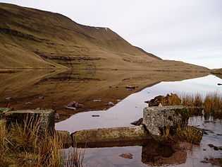
Llyn y Fan Fawr (Welsh: 'lake of the big peak') is a natural lake in the county of Powys, Wales. It lies at the foot of Fan Brycheiniog, the highest peak of the Black Mountain range within the Brecon Beacons National Park.
The lake is enclosed within a rock hollow formed as a result of glacial action during the ice ages. It is drained by a stream known as Nant y Llyn (Welsh: 'stream of the lake'), whose waters flow into the River Tawe. The surface of Llyn y Fan Fawr lies at about 605 m above sea level.[1]
Llyn y Fan Fach (Welsh: 'lake of the small peak') which lies about 2 miles (or 3 km) to the west is of similar origin and size but was dammed in the 1930s.
The lake can be reached on foot by a mile walk (or about 2 km) across the moor from the minor Trecastle to Glyntawe road.
References
- ↑ Ordnance Survey Explorer map OL12 'Brecon Beacons National Park: western area'