Lluçanès

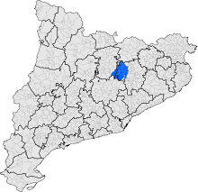
Lluçanès (Catalan pronunciation: [ʎusəˈnɛs]) is a natural region transitioning between the Plain of Vic and Berguedà, in the pre-Pyrenees. Although not an officially recognized comarca of Catalonia, it has a strong historical, natural and social personality.
Corresponding municipalities
It is made up of the following municipalities:
- In the comarca of Osona: Alpens, Lluçà, Olost, Oristà, Perafita, Prats de Lluçanès, Sant Agustí de Lluçanès, Sant Bartomeu del Grau, Sant Boi de Lluçanès, Sant Martí d'Albars, Sobremunt.
- In the comarca of Berguedà: Santa Maria de Merlès
- In the comarca of Bages: Sant Feliu Sasserra.
Geography
Lluçanès is a plateau of about 400 km2, situated in the north-east of the depressió central of Catalonia
The major waterways of the comarca include the Ter and Llobregat rivers, into which the Riera de Merlès, Riera de Lluçanès and Gavarresa feed.
Lluçanès has a Mediterranean climate transitioning to continental. It has a median temperature of about 12 degrees Celsius, and receives an annual precipitation of between 600 and 900 liters.
New comarca debate

In the "Report on the revision of Catalonia's territorial organisation model" of 2000, known as the Roca Report, commissioned by the Catalan government, it was recommended that Lluçanès should become a sub-comarca of Osona.[1] However, the people of the region are due to vote on 26 July 2015 on whether they wish to form a new full comarca.[2]
This follows the example of nearby Moianès, which (as recommended by the Roca Report) is to become a new comarca in May 2015.
References
- ↑ Miquel Roca i Junyent et al. (December 2000). "Informe sobre la revisió del model d'organització teritorial de Catalunya" (in Catalan). p. 44, 119. Archived from the original on 2015-04-16.
- ↑ Pere Pratdesaba (2015-03-11). "El Lluçanès decidirà el 26 de juliol si vol esdevenir comarca" (in Catalan). ca:Nació Digital. Retrieved 2015-04-16.