Llogara National Park
| Llogara National Park | |
|---|---|
| Parku Kombëtar i Llogarasë/Llogorasë | |
|
IUCN category II (national park) | |
|
Forests of Llogara National Park | |
 | |
| Location | District of Vlorë, south-west Albania |
| Nearest city | Vlora |
| Coordinates | 40°12′52″N 19°34′51″E / 40.2145°N 19.5809°ECoordinates: 40°12′52″N 19°34′51″E / 40.2145°N 19.5809°E[1] |
| Area | 1,010 ha (2,500 acres) |
| Established | 1966 |
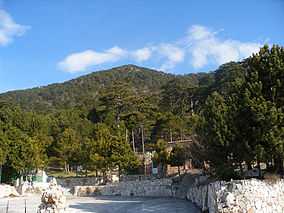
Llogara or Llogora National Park (Albanian: Parku Kombëtar i Llogarasë/Llogorasë) is a national park in Albania declared since 1966 by the Albanian Government.[2] The park covers an area of 1,010 hectares (2,500 acres) and protects the forests on the north side of the Llogara Pass between a height from 470 to 2,018 m (1,542 to 6,621 ft) above sea level. In the park can be found many black pine (Pinus nigra) trees, Bosnian pines (Pinus heldreichii), Bulgarian fir, (Abies borisii-sign) and ash trees (Fraxinus).
Air currents around the area have caused trees to bend in many interesting shapes, like the Pisha e Flamurit.[3]
Fauna
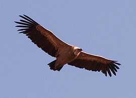
- Griffon vulture
- Golden eagle
- Rock partridge
- Fallow deer
- Roe deer
- European wildcat
- Chamois
- Red squirrel
- Eurasian otter
- European otter
- Stone marten
- Wolf
- Red fox
Recreation
Along the road are several restaurants, hotels, and a small wooden cabin complex. The area of the park and the surrounding mountains are used mainly for hiking and tracking tours. A paragliding site serving annually as an international competition venue is located south of Llogara. Along the twisting road are several local vendors of honey and mountain tea. Caesar's Pass (Qafa e Cezarit) named after Julius Caesar who set foot in the area in pursuit of Pompey is also located near Llogara Pass.
See also
References
- ↑ "Llogara National Park". protectedplanet.net.
- ↑ "RRJETI I ZONAVE TE MBROJTURA NE SHQIPERI" (PDF). Albanian Ministry of Environment, Forests and Water Administration. Retrieved 2010-06-30.
- ↑ "Llogara National Park". CMS Lounge.
External links
| Wikimedia Commons has media related to Llogara. |
| ||||||||||||||||
| ||||||||||||||||||