Llanfair-yn-Neubwll
| Llanfair-yn-Neubwll | |
| Welsh: Llanfair-yn-Neubwll | |
 RAF Valley |
|
 Llanfair-yn-Neubwll |
|
| Population | 1,688 (2001) |
|---|---|
| OS grid reference | SH302765 |
| Community | Llanfair-yn-Neubwll |
| Principal area | Anglesey |
| Ceremonial county | Gwynedd |
| Country | Wales |
| Sovereign state | United Kingdom |
| Post town | HOLYHEAD |
| Postcode district | LL65 |
| Dialling code | 01407 |
| Police | North Wales |
| Fire | North Wales |
| Ambulance | Welsh |
| EU Parliament | Wales |
| UK Parliament | Ynys Môn |
| Welsh Assembly | Ynys Môn |
Coordinates: 53°15′32″N 4°32′46″W / 53.258886°N 4.546176°W
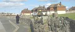
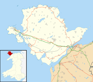
Llanfair-yn-Neubwll is a community and village on the Isle of Anglesey in the north west of Wales. The community includes the villages of Llanfihangel yn Nhowyn and Caergeiliog, and has a population of 1,688.[1] The community is heavily connected to the nearby Royal Air Force airfield, RAF Valley, established on Tywyn Trewan during the Second World War, and still in use. Due to the founding of the airfield, Llanfair-yn-Neubwll is the most Anglicised of the communities on Anglesey.[2]
Llanfair-yn-Neubwll lies on the western coast of Anglesey looking out towards Holy Island. Notable geographic features of the area include the offshore rocks of Ynys Feirig and the eight lakes known as Ardal y Llynnoedd. Many of the lakes are included in Valley Wetlands RSPB reserve.
References
- ↑ Office for National Statistics : Census 2001 : Parish Headcounts : Isle of Anglesey Retrieved 10 January 2010
- ↑ The Welsh Academy Encyclopaedia of Wales. John Davies, Nigel Jenkins, Menna Baines and Peredur Lynch (2008) p488 ISBN 978-0-7083-1953-6
External links
| ||||||