Llandanwg
| Llandanwg | |
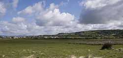 Llandanwg (left) and Llanfair (on the hill) |
|
 Llandanwg |
|
| OS grid reference | SH570285 |
|---|---|
| Principal area | Gwynedd |
| Ceremonial county | Gwynedd |
| Country | Wales |
| Sovereign state | United Kingdom |
| Post town | HARLECH |
| Postcode district | LL46 |
| Dialling code | 01341 |
| Police | North Wales |
| Fire | North Wales |
| Ambulance | Welsh |
| EU Parliament | Wales |
| UK Parliament | Meirionnydd Nant Conwy |
| Welsh Assembly | Dwyfor Meirionnydd |
Coordinates: 52°50′09″N 4°07′27″W / 52.8358°N 4.1243°W
Llandanwg is a village in the Ardudwy area of Gwynedd, Wales.
The village of Llandanwg is situated to the west of the coastal road between Llanbedr and Harlech, close to the village of Llanfair. Originally it was a small collection of farms to the north of the river Artro, close to where it enters the sea. Later developments expanded the size of the village. There is an easily accessible beach, which is popular in the summer months, at the end of the road through the village.
The parish church of Saint Tanwg at Llandanwg is situated just behind the beach in the sand dunes. The church is medieval, probably dating from the 13th century, however there are two 6th century inscribed stones which indicates much earlier activity, and it has probably been a place of worship from the early 5th century.[1]
Llandanwg Halt on the Cambrian Line serves the village.
The area in front of the church, known as the Maes (Y Maes), and some of the sand dunes surrounding the church are owned by the National Trust.
Llandanwg Gallery
-
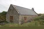
Llandanwg church from the churchyard
-
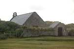
Llandanwg church from Y Maes
-
Llandanwg viewed from above the main road with Mochras (Shell Island) in the background
-

Llandanwg Halt, a design typical of the Cambrian line. The Great Western opened many such halts between 1923 and 1935 along this line similar to this one.
-

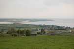
Llandanwg and Shell Island from the north
References
- ↑ Llandanwg - Llanddyvnan', A Topographical Dictionary of Wales (1849), pp. 505-11. URL: http://www.british-history.ac.uk/report.asp?compid=47844
External links
- National Rail - Llandanwg Halt
- Good Beach Guide - Llandanwg
- www.geograph.co.uk : photos of Llandanwg and surrounding area
- Llandanwg Beach, St. Tanwg Church, North Wales, UK on YouTube
