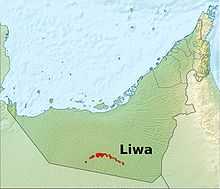
Liwa Oasis

The Liwa Oasis (واحة ليوا in Arabic) is a large oasis area in Abu Dhabi, United Arab Emirates.
Geography
Liwa Oasis is about 100 km south of the Persian Gulf coast and 150 km SSW of the city of Abu Dhabi in the Al Gharbia (Western) Region, on the northern edge of Rub' al Khali desert. It is centered around 23°08′N 53°46′E / 23.133°N 53.767°E and stretches about 100 km east-west, along an arch curved to the north. It consists of some 50 villages. The geographic and economic center of the oasis is Muzayri`, where the highway from Abu Dhabi enters the oasis and then divides to the east (65 km to the easternmost village, Mahdar Bin `Usayyan) and west (45 km to the westernmost village, `Aradah).
According to the census of population of 2005, the population was 20,196.[1] Earlier estimates judging from satellite images which gauged the population at 50,000 to 150,000, were too high.[2]
The villages of Liwa Oasis are the southernmost settlements of Abu Dhabi and of the United Arab Emirates. The southern border of Abu Dhabi with Saudi Arabia, which runs at a distance between 16 and 35 km to the Oasis, is a straight line in the Rub al Khali desert, which is largely uninhabited. Mahdar Bin `Usayyan is the southernmost village of the Emirates, and also the easternmost of the oasis. 10 km south of the border, and 40 km south of the eastern part of the oasis is the Saudi oil facility Shaybah. However, there is no road linking Liwa Oasis and Shaybah, and no border crossing.
A modern, multilane highway connects the oasis area to the capital, Abu Dhabi.
Economy
An important traditional branch of the economy is date farming. There is a widespread use of drip irrigation and greenhouses. The importance of tourism is on the rise. Liwa Hotel in Muzayri` boasts Three stars. Liwa Rest House, in the same village and run by the government of Abu Dhabi, is the second establishment in the oasis. It is primarily aimed at minor officials and businessmen. Construction has begun on a third, 5 star, resort (named Qasr Al Sarab Al Sarab ). The nearby Moreeb dune22°59′N 53°47′E / 22.983°N 53.783°E, 22 km south of Muzayri` on a small road (15 km as the crow flies), with 300 meter height one of the largest dunes in the world, attracts every year during the [http://www.etisalat.ae/index.jsp?lang=en&type=content¤tid=6d88e15c0b56a010VgnVCM1000000a0a0a0a____&contentid=3fb3b061a9857110VgnVCM1000000c24a8c0RCRD&parentid=ed38800d1f52a010VgnVCM1000000a0a0a0a____ Liwa festival a large number of international and local visitors coming to see the offroad and camel racing events.
History
The oasis is the place of birth of the ruling families of Abu Dhabi and Dubai. In 1793, the ruling family Al Nahyan moved their residence from Liwa to the city of Abu Dhabi.[3]
Traditionally, men from Liwa (Bani Yas tribe) were pearl divers on the coast during the summer months. Pearl diving offered an additional source of income.
Villages
The USGS Geographic Names Database[4] lists 39 populated places in the area of the oasis, which are listed from west to east in the following table. Some of the more important villages are printed in bold.
References
- ↑ Abu Dhabi Report
- ↑ "Liwa Oasis". Lexiorient. Retrieved 2012-07-05.
- ↑ Motohiro, Ono (March 2011). "Reconsideration of the Meanings of the Tribal Ties in the United Arab Emirates: Abu Dhabi Emirate in Early ʼ90s". Kyoto Bulletin of Islamic Area Studies 4–1 (2): 25–34. Retrieved 17 April 2013.
- ↑ "Complete Files of Geographic Names for Geopolitical Areas from GNS (ISO/IEC 10646 [Unicode UTF-8]". Earth-info.nga.mil. Retrieved 2012-07-05.
| ||||||||||||||||||||||||||||||