Little Clifton
| Little Clifton | |
 Little Clifton |
|
| Population | 391 |
|---|---|
| OS grid reference | NY0553 528651 |
| Civil parish | Little Clifton |
| District | Allerdale |
| Shire county | Cumbria |
| Region | North West |
| Country | England |
| Sovereign state | United Kingdom |
| Postcode district | CA14 |
| Dialling code | 01900 |
| Police | Cumbria |
| Fire | Cumbria |
| Ambulance | North West |
| EU Parliament | North West England |
Coordinates: 54°38′38″N 3°27′50″W / 54.644°N 3.464°W

Little Clifton is a civil parish in the district of Allerdale located on the edge of the Lake District in the county of Cumbria, England. In 2001 it had a population of 391[2] and contained 170 households.[3] The village of Little Clifton is 0.3 miles south of Bridgefoot (although it is hard to tell where one ends and the other begins) and 3.5 miles east of Workington. The river Derwent is roughly 1 mile north of Little Clifton. In 1887 John Bartholomew, whilst writing for the Gazetteer of the British Isles, described Little Clifton as a township of 489 persons within a parish 3½ miles SE of Workington. Workington was, at that time, a district within the former county of Cumberland.[4]
Early area history and Toponymy
Cumbria is formed of the older counties of Cumberland, Westmorland, parts of North Lancashire and North Yorkshire. There are signs of human inhabitancy as early as 5000 years ago with stone circles discovered under 20 miles east of Little Clifton at Long Meg and Castlerigg amongst other places. The early settlements are in areas suitable for crafting tools such as stone axes and became the source for quarrying in the area.[5]
Celtic immigration began around 500BC and developed in Cumbria as Brigantes. Celtic Brigantians had a major settlement at Carlisle and inhabited the area later known as Rheged around 100CE.[6] The Celts flourished following Roman rule after the transitional period of Roman rule to Celtic rule c350-420AD. Anglo Saxon invasion absorbed Rheged into the (now) powerful Anglo Saxon kingdom of Northumbria c.630AD. It is From the Anglo Saxons that Little Clifton gained its name.[7] The suffix ‘ton’ in Little Clifton is Anglo Saxon or ‘old English’ for enclosure, estate or homestead.[8]
Mining
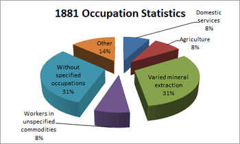
Mining in Cumbria plays a large role in its history. Lead, copper, zinc, barite, haematite, tungsten, graphite, fluorite, and coal have all been mined at different times since as early as the 12th century.[10] Western parts of Cumbria, and in particular the Whitehaven area, proved to contain haematite in large shallow deposits which were exploited by early miners. The first documented mining in the Cumrbian area was in Bigrigg mine roughly 15 miles south of Little Clifton in the parish of Egremont. It is believed that Romans mined this area and later on by early British and Norse settlers.[11] In 1881 31% of the inhabitants of Little Clifton were involved in mineral extraction, the highest single occupation in the parish at that time.[12] Force Crag mine in Keswick was the closest mine to Little Clifton which was mined for lead, zinc and barytes from 1839 to its closure in 1991. Force Crag mine is now run by the National Trust and open to the public.[13]
St Luke's Church
(OSGB36: NY 054 290 [100m precision] WGS84: 54:38.8700N 3:28.0354W)[14]

The site of St Luke’s Church dates back to Norman times and has various Norman artefacts such as a Norman archway and Norman cross shaft in the graveyard. The current church dates back to 1901 and contains some superb stained glass windows and other furnishings donated by local families. The church regularly holds concerts, events and open days.[15]
Punderland Farm
Punderland farm featured on the BBC,[16] amongst other British news mediums, due to a ‘tragic mistake’ which caused the unnecessary slaughter of 200 ewes, 300 lambs and a pet pig. The mishap occurred because of a grid reference error of one digit during the foot and mouth outbreak in 2001. The intended farm for destruction was in Durham 100 miles away. No more compensation was granted than the standard for loss of livestock at the time and no legal firm would go to court for what would be a costly battle.[17]
References
- ↑ "Population Decline". www.visionofbritain.org.uk. Retrieved 12 April 2012.
- ↑ "Population Statistics". www.neighbourhood.statistics.gov.uk. Retrieved 20 March 2012.
- ↑ "Household Statistics". www.neighbourhood.statistics.gov.uk. Retrieved 20 March 2012.
- ↑ "Historic Description of Little Clifton". www.visionofbritain.org.uk. Retrieved 28 April 2012.
- ↑ "Ancient Settlements". www.visitcumbria.com. Retrieved 20 March 2012.
- ↑ "Celtic History". www.celtnet.org.uk. Retrieved 20 March 2012.
- ↑ "Saxon History". www.inheritage.org. Retrieved 25 March 2012.
- ↑ "List of generic forms in British place names". www.wikipedia.org. Retrieved 25 March 2012.
- ↑ "Occupational Statistics". www.visionofbritain.org.uk. Retrieved 12 April 2012.
- ↑ "Mining in Cumbria". www.visitcumbria.com. Retrieved 26 April 2012.
- ↑ "Early Mining". www.cumbria-industries.org.uk. Retrieved 26 April 2012.
- ↑ "Occupational Statistics". www.visionofbritain.org.uk. Retrieved 12 April 2012.
- ↑ "Force Crag Mine". www.visitcumbria.com. Retrieved 26 April 2012.
- ↑ "Coordinates of St Luke’s". www.geograph.org.uk. Retrieved 26 April 2012.
- ↑ "St Luke’s CofE". www.ctfc.org.uk. Retrieved 26 April 2012.
- ↑ "Accidental Mass Slaughter BBC". news.bbc.co.uk. Retrieved 1 May 2012.
- ↑ "Accidental Mass Slaughter NWEM". www.nwemail.co.uk. Retrieved 1 May 2012.