Little Beaver Creek
| Little Beaver Creek | |
|---|---|
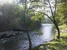
 Little Beaver Creek as it passes near the unincorporated Village of Fredericktown, Ohio | |
| Origin | Confluence of Middle and West Forks at Williamsport, Ohio |
| Mouth | Ohio River at Glasgow, Pennsylvania |
| Source elevation | 840 ft (256 m) [1] |
| Mouth elevation | 665 ft (203 m) [2] |
| Basin area | 605 mi² (1,567 km²) [3] |
The Little Beaver Creek is a wild and scenic area in Ohio. The Little Beaver Creek watershed is located primarily in Columbiana County in northeast Ohio, and in portions of Carroll County, Mahoning County, and western Pennsylvania, draining approximately 605 mi² (1,567 km²), of which 503 mi² (1,303 km²) are in Ohio. The watershed in total size covers an area of approximately 510 square miles, with about 80% of this being situated in Ohio. The great majority land in the watershed is privately owned. Within the watershed are roughly 808 miles of linear streams.
The creek is protected by a number of classifications, including Ohio Wild and Scenic River and National Scenic River, as well as being part of Ohio's state park system. It is the only major river in Ohio to have dual State Wild and Scenic and National Scenic River designations, and was the first in the country to earn both distinctions. The creek empties into the Ohio River just east of East Liverpool, Ohio. The now-defunct Sandy and Beaver Canal passes nearby.
According to an Ohio Department of Natural Resources study conducted in 2004, Little Beaver Creek is an exceptionally clean waterway with a highly diverse ecosystem. It supports 63 species of fish, 49 mammal species, 270 species of migratory and resident birds and 46 species of reptiles and amphibians, including the rare and protected salamander known as the hellbender.
The Little Beaver Creek watershed is home to Beaver Creek State Forest,[4] Beaver Creek State Park,[5] and Sheepskin Hollow State Nature Preserve.[6]
Variant names
According to the Geographic Names Information System, the Little Beaver Creek has also been known as:[7]
- Beaver Creek
- Little Beaver River
- Middle Fork Beaver Creek
- Little Bever Creek
See also
References
- ↑ U.S. Geological Survey. West Point quadrangle, Ohio. 1:24,000. 7.5 Minute Series. Washington D.C.: USGS, 1992.
- ↑ U.S. Geological Survey. East Liverpool North quadrangle, Ohio. 1:24,000. 7.5 Minute Series. Washington D.C.: USGS, 1994.
- ↑ "Map of Ohio watersheds".
- ↑ Beaver Creek State Forest
- ↑ Beaver Creek State Park
- ↑ Sheepskin Hollow State Nature Preserve
- ↑ U.S. Geological Survey Geographic Names Information System: Little Beaver Creek
External links
| ||||||||||||||||||||||||||||||||||||||||||||||||||||||||||||||||||||
- The Enchanted Village: The History of Fredericktown, Ohio by Regis Scharf and Gary Winterburn was privately published in 1992. It has long been out of print, although a new edition is being planned.
- Management plan for the Little Beaver Creek watershed
- St. Clair Township Travel & Tourism Bureau
- February 10, 1976 letter from President Gerald R. Ford entitled "Message to the Congress Transmitting Report on Little Beaver Creek, Ohio"