List of transcontinental countries
This is a list of countries spanning more than one continent, known as transcontinental states, or more properly as intercontinental states. While there are many countries with non-contiguous overseas territories fitting this definition, only a limited number of countries have territory spanning an overland continental boundary, most commonly the line that separates Europe and Asia. The convention of 1730 drew an arbitrary line between Europe and Asia that didn't take any international boundaries into account. This has resulted in a couple of Transcaucasian countries finding themselves almost entirely in "Asia", with a few small enclaves or districts technically in "Europe". These small mountainous nation states show no obvious signs of occupying two continents each. Notwithstanding these anomalies, this list of transcontinental or intercontinental states respects the convention that Europe and Asia are full continents rather than subcontinents or component landmasses of the larger Eurasian continent.
- Asian–European boundary: Azerbaijan, Georgia, Kazakhstan, Russia, Turkey
- African–Asian boundary: Egypt
Note: Colombia and Panama are generally considered to be entirely within South America and North America respectively.
Listed further below, separately, are countries with distant non-contiguous parts (overseas territories) on separate continents.
Contiguous boundary
Africa and Asia
The land border between Asia and Africa is considered to go along the Isthmus of Suez and the Suez Canal in Egypt. The border continues through the Gulf of Suez, Red Sea and Gulf of Aden.
Egypt
Two of 27 governorates of Egypt lie entirely on the Asian Sinai Peninsula and two are transcontinental: Ismailia Governorate is nearly equally divided by the Suez Canal, and Suez Governorate, which is coterminous with the transcontinental city of Suez, has a small portion east of the Canal.
Asia and Europe
The modern conventional definition of Europe (e.g. National Geographic Society, CIA World Fact Book) has the Europe-Asia boundary follow the watershed of the Ural Mountains to the source of the Ural River, then follows that river to the Caspian Sea. The border then follows the Greater Caucasus watershed from the Caspian Sea to the Black Sea. According to this mainstream but not universally accepted definition (some geographers consider Europe and Asia a single continent, Eurasia),[1] there are five states with territory across the continental boundary:
- Russia: with most of its population situated in Europe, has significant territory in Central and Northern Asia (Siberia in the Russian Far East). About 75% of the Russian population lives in the European part.
- Turkey: mostly situated in Asia Minor, with some territory in Southeastern Europe (Turkish Thrace). About 88% of the Turkish population lives in the Asian part.
- Kazakhstan: mostly situated in Central Asia, with the western parts of two of its provinces west of the Ural River in Europe. About 96% of the Kazakh population lives in the Asian part.
- Azerbaijan: primarily situated in Asian Transcaucasia, with five northeastern districts ("rayons") in European Ciscaucasia, north of the Greater Caucasus watershed. About 98% of the Azerbaijani population lives in Transcaucasia.
- Georgia: primarily situated in Asian Transcaucasia, with a small area in Europe just north of the Greater Caucasus watershed. More than 99% of the Georgian population lives in Transcaucasia.
A convention sometimes used in Russian geography draws the continental boundary along the Manych River to the Caspian, excluding Georgia and Azerbaijan from transcontinental status. A historical convention used in the 19th century followed the lower Volga instead of the Ural river, which would also exclude Kazakhstan from being transcontinental.
Azerbaijan
The northeastern Azerbaijan district borders run mostly along the main Caucasus watershed.[2] Five districts are entirely within Europe, and the transcontinental Khizi district is almost equally divided on the two sides of the watershed. The remaining 53 districts are within Asia. Nevertheless, Azerbaijan is a member of the Council of Europe.
Georgia

The Terek and Sulak rivers both originate in Georgia and both empty into the Caspian Sea in Dagestan; their upper basins in Georgia are north of the Greater Caucasus watershed (the modern-day Europe-Asia divide), including northern parts of the Tusheti and Khevsureti historical regions and Kazbegi District. A total of 2,650 square kilometers, or 4% of Georgia's territory, is north of the Caucasus Mountains and thus in Europe. The remaining 96% of the country is in Asia.
Kazakhstan
Kazakhstan's provincial borders do not follow the Ural River, although some of its western district borders do so. Two of the provinces are transcontinental, Atyrau Province and West Kazakhstan Province. The capital of the former, Atyrau, is split by the mouth of the Ural and is a transcontinental city. Almost all of it is in Asia with a small portion in Europe. Two of Atyrau Province's districts are entirely in Europe, three of its districts are entirely in Asia, and its Inderskiy and Makhambetskiy districts are transcontinental.[3] Five of West Kazakhstan's districts and the province's capital city of Oral are entirely in Europe, five of its districts are entirely in Asia, and its Akzhaikskiy district is transcontinental.[4]
Russia
Russian regions' borders follow the continental divide (Ural Mountains and Ural River) more often than not. There is also the relatively small 2600 square kilometer Sochi area of Russia in Asia, bordering Georgia and located south of the main Caucasus watershed. Orenburg on the Ural River is a transcontinental city. More detail on the political divisions through which the intercontinental boundary runs can be found here. Russia is a member of the Council of Europe.
Turkey
The Bosphorus, Dardanelles, and Black Sea are the only linked salt-waterways that separate Europe and Asia. Consequently, Turkey is the only country on the conventional Europe-Asia boundary that shows any obvious appearance of being on two continents. Three of Turkey's provinces (Edirne, Kırklareli and Tekirdağ) are entirely in Europe, the province of Edirne also having a small territory in Western Thrace, while Çanakkale and Istanbul are transcontinental provinces. Three of Çanakkale's districts are entirely in Europe and its other nine districts are entirely in Asia. Nineteen of Istanbul's districts are entirely in Europe and its other twelve districts are entirely in Asia.
North and South America
- See Borders of the continents for more details about the geographical border between the two Americas.
Non-contiguous
Asia and Europe
- The territory of Greece includes a number of islands just off the coast of Asia Minor, such as Rhodes, Samos, Chios and Kastellorizo.
Europe and North America
- Greenland: Greenland is a country within the Kingdom of Denmark, fully located on the North American tectonic plate and close to the mainland, and is considered to be geographically part of North America. Although it is politically associated with Europe and internationally represented by a European country (including in the Council of Europe), it is autonomous. Historically and ethnically, its native population is of American tradition, although it also shares cultural links with other native peoples bordering the Arctic Sea in Northern Europe and Asia (today in Norway, Sweden, Finland and Russia), as well as in North America (Alaska in the U.S., Northwest Territories and Nunavut in Canada). Greenland was part of the Danish territory and within the territory of the European Union, but voted for a larger autonomy and is now excluded from it.
- Iceland: Iceland is on the fracture line splitting the Northern Atlantic Ocean between the North American plate and the Eurasian plate. Measuring to the North American island of Greenland, Iceland is much closer to North America than it is to Europe; however it is over twice as close to mainland Europe than to mainland North America. Using a plate tectonics definition, Iceland would qualify as a transcontinental country. However, "continents" are defined by conventions that predate any knowledge of plate tectonics, even though many of the plates are named for the continents that occupy them. Geographically, ethnically, historically, and culturally, Iceland is commonly considered to be European and not transcontinental. Iceland is a full member of the Council of Europe (but still not in the European Union, to which it could qualify).
- The Netherlands are mostly in Europe. However, since the dissolution of the Netherlands Antilles on 2010-10-10, the country includes the three "special municipalities" of Bonaire, St. Eustatius and Saba (collectively known as the BES islands) in the Caribbean area.
- Portugal: Continental Portugal is in Europe, while the Azores archipelago (also associated with Europe) has two islands (Corvo and Flores) that are part of the American plate. This might make Portugal a tricontinental country except for the fact that continents, as already noted, are not defined by tectonic plates.
Europe, North America, South America, Oceania, and Africa
- France: Metropolitan France is in Europe, while the five Overseas Departments and six Overseas Collectivities are in other continents. Guadeloupe, Martinique, Saint-Martin, Saint-Barthélemy, and Saint-Pierre and Miquelon are in North America, French Guiana is in South America, Mayotte and Réunion are in Africa, and New Caledonia, French Polynesia, and Wallis and Futuna are in Oceania. These Overseas Departments and Collectivities are integral parts of France, as are the uninhabited French Southern and Antarctic Lands and Clipperton Island.
Africa and Europe
- See Borders of the continents for more details about the geographical border between Africa and Europe.
- Italy: Although mainland Italy, Sardinia, Sicily, the Aegadian Islands, Ustica, and the Aeolian Islands are associated with Europe, the closest land to Pantelleria and the Pelagie Islands (Lampedusa, Linosa and Lampione) is Tunisia on the African mainland. Nevertheless, Pantelleria and Linosa are considered part of Europe, Lampedusa and Lampione part of Africa.
- Portugal: Continental Portugal is in Europe, while the archipelago of Madeira, an autonomous region of Portugal (including Porto Santo Island, the Desertas Islands and the Savage Islands), is associated with Africa. If we consider that the Azores autonomous region of Portugal has two islands (Flores and Corvo) that are part of North American tectonic plate (see Europe and North America section above), Portugal would be a tricontinental country except for the fact these plates are not defined as continents.
- Spain: Although its mainland is in Europe, Spain has holdings (the Canary Islands in the Atlantic, the cities of Ceuta and Melilla on mainland North Africa and its Plazas de soberanía close to those cities) that are geographically part of Africa. The Canary Islands, Ceuta and Melilla are three of the 19 autonomous communities and cities that form Spain, while the Plazas de Soberanía are under different military status. The African Mediterranean island of Isla de Alborán belongs to the transcontinental city of Almería and the transcontinental province of Almería.
Asia and Africa
- Yemen: Although mainland Yemen is in the southern Arabian Peninsula and thus part of Asia, and its Hanish Islands and Perim in the Red Sea are associated with Asia, Yemen controls the archipelago of Socotra, which lies east of the horn of Somalia and is much closer to Africa than Asia. Socotra and the Hadramawt region constitute the transcontinental Hadramawt Governorate.
Asia and Oceania
- Australia: The Commonwealth of Australia consists of its namesake continent and island possessions associated with Oceania, Asia, and Antarctica. Its Indian Ocean island possessions of Christmas Island and the Cocos (Keeling) Islands are associated with Asia. The majority of Australia's Asian island residents have Asian ancestry and are Muslim or Buddhist.
- Japan: All of Japan consists of Asian islands except for the remote Bonin Islands, also known as the Ogasawara Islands, which are Pacific islands administered by Ogasawara, Tokyo.
- Papua New Guinea: Anthropologically Papua New Guinea is a part of Melanesia and is sometimes included in the Malay Archipelago. It is an observer in ASEAN and has contemplated full membership.[5]
- Philippines, Malaysia, Indonesia, East Timor, Brunei and Singapore: The Malay Archipelago lies on the border of Oceania and Asia. Depending on the interpretation of the border, Philippines, Malaysia and Indonesia can be considered transcontinental countries and East Timor, Brunei and Singapore can be in either side.
North America, Oceania and Asia
- United States: While the territory of the United States lies overwhelmingly in North America, it includes the state of Hawaii in Oceania as well as other Oceanian island possessions and Alaskan islands on NE Asia's continental shelf.
North and South America
- Aruba, Bonaire, Curaçao and Trinidad and Tobago: The sea islands division of South America and North America is complicated. All Caribbean islands are often labeled as North American, but the Dutch dependencies of Aruba and Curaçao, and the Dutch special municipality of Bonaire lie on the continental shelf of South America, and can be considered South American as well. What complicates it even further is that the islands of Trinidad and Tobago lie on two continental shelves. The southern half of Trinidad lies in South America and the northern half of Trinidad, and Tobago, lie on the Caribbean plate. All these islands have closer cultural ties with North America.
- Colombia: Mainland Colombia is in northwestern South America and Malpelo Island in the Pacific Ocean is also associated with South America, but the nation also controls the San Andrés and Providencia archipelago, 640 kilometres (400 mi) WNW of Colombia's Caribbean coast, near the Caribbean coast of Nicaragua. This archipelago is coterminous with the department of the same name.
- Venezuela: Mainland Venezuela is in South America, but Isla Aves are geographically North American. Isla Aves is one of the federal dependencies of Venezuela under the administration of the transcontinental city of Caracas.
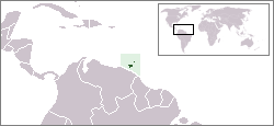
North American Caribbean islands belonging to South American countries:
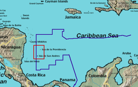 San Andrés and Providencia |
South American Caribbean islands:
Other examples
- Chile is mostly on the South American mainland and includes the Oceanian islands of Easter Island and Sala y Gómez Island. They and the outlying South American Juan Fernández Islands and Desventuradas Islands are part of the Valparaíso Region.
- The Danish Realm includes Denmark as well as the North American island of Greenland and the Faroe Islands associated with Europe. Greenland was integrated into the Danish Realm in 1953 and home rule was granted in 1979.
- The Kingdom of the Netherlands includes the constituent countries of Aruba, Curaçao, and Sint Maarten. In addition, after the split of the Netherlands Antilles the Caribbean islands of Bonaire, Sint Eustatius and Saba became special municipalities incorporated into the metropolitan Netherlands.
These examples have integral parts associated with other continents. Norway, South Africa, and the United Kingdom may also be considered transcontinental by virtue of their distant island possessions or territories associated with a continent other than where the country is based.
Antarctica: claims
A number of nations claim ownership over portions of the continent of Antarctica. Some, including Argentina and Chile, consider the Antarctic land they claim to be integral parts of their national territory. Some nations also have sub-Antarctic island possessions north of 60°S latitude and thus recognized by international law under the Antarctic Treaty System, which holds in abeyance land claims south of 60°S latitude.
See also
- Borders of the continents
- Dependent territory
- Historical powers
- List of countries by continent
- List of transcontinental empires and countries in history
- List of cities spanning more than one continent
- Thalassocracy
References
- ↑ National Geographic Society (1996). "How Many Continents?". Retrieved 2014-09-03.
- ↑ Islam: A Threat to Civilization, p. 15, at Google Books
- ↑ Brif.kz
- ↑ Brif.kz
- ↑ "Papua New Guinea asks RP support for Asean membership bid". GMA News. Retrieved 15 July 2014.