List of the most prominent summits of North America
The following sortable table lists the 200 most topographically prominent mountain peaks of greater North America.
This article defines greater North America as the portion of the continental landmass of the Americas extending northward from Panama plus the islands surrounding that landmass. This article defines the islands of North America to include the coastal islands of North America, the islands of the Caribbean Sea, the Lucayan Archipelago, the Bermuda Islands, the Islands of Greenland (Kalaallit Nunaat), the islands of Northern Canada, the islands of Alaska, and the islands of the northeastern Pacific Ocean. The Hawaiian Islands are not included because they are considered part of Oceania.
Topographic elevation is the vertical distance above the reference geoid, a precise mathematical model of the Earth's sea level as an equipotential gravitational surface. Topographic prominence is the elevation difference between the summit and the highest or key col to a higher summit. Topographic isolation is the minimum great circle distance to a point of higher elevation.
This article defines a significant summit as a summit with at least 100 meters (328.1 feet) of topographic prominence, and a major summit as a summit with at least 500 meters (1640.4 feet) of topographic prominence. An ultra-prominent summit is a summit with at least 1500 meters (4921.3 feet) of topographic prominence. There are 355 ultra-prominent summits in greater North America.
All elevations in the 48 states of the contiguous United States include an elevation adjustment from the National Geodetic Vertical Datum of 1929 (NGVD 29) to the North American Vertical Datum of 1988 (NAVD 88). For further information, please see this United States National Geodetic Survey note.
Of these 200 most prominent summits, 81 are located in the United States, 74 in Canada, 16 in Mexico, 16 in Greenland, 7 in Guatemala, 2 in Costa Rica, 2 in the Dominican Republic, 2 in Haiti, 2 in Honduras, and one each in Jamaica, Cuba, El Salvador, and Panama. Six of these peaks lie on an international border.
In North America, only Mount McKinley exceeds 6000 meters (19,685 feet) of topographic prominence, and Mount Logan exceeds 5000 meters (16,404.2 feet) of prominence. Four peaks exceed 4000 meters (13,123.4 feet), 17 exceed 3000 meters (9842.5 feet), 101 exceed 2000 meters (6561.7 feet), and 355 exceed 1500 meters (4921.3 feet) of topographic prominence.
Table
| Rank | Mountain Peak | Region | Mountain Range | Elevation | Prominence | Isolation | Location |
|---|---|---|---|---|---|---|---|
| 1 | Mount McKinley[1][2] (Denali) |
Alaska Range | 6194 m 20,320 ft | 6149 m 20,174 ft | 7,450 km 4,629 mi |
63.0690°N 151.0063°W | |
| 2 | Mount Logan[3][4] | Saint Elias Mountains | 5956 m 19,541 ft | 5247 m 17,215 ft | 623 km 387 mi |
60.5666°N 140.4072°W | |
| 3 | Volcán Citlaltépetl[5][6] (Pico de Orizaba) |
Cordillera Neovolcanica | 5636 m 18,491 ft | 4922 m 16,148 ft | 2,690 km 1,672 mi |
19.0305°N 97.2698°W | |
| 4 | Mount Rainier[7][8][9][10] | Cascade Range | 4394 m 14,417 ft | 4034 m 13,236 ft | 1,177 km 731 mi |
46.8521°N 121.7579°W | |
| 5 | Volcán Tajumulco[11][12] | San Marcos | 4220 m 13,845 ft | 3980 m 13,058 ft | 722 km 448 mi |
15.0445°N 91.9035°W | |
| 6 | Mount Fairweather[13][14] (Fairweather Mountain) |
Saint Elias Mountains | 4671 m 15,325 ft | 3961 m 12,995 ft | 201 km 125 mi |
58.9064°N 137.5265°W | |
| 7 | Chirripó Grande[15][16] (Cerro Chirripó) |
Cordillera de Talamanca | 3819 m 12,530 ft | 3726 m 12,224 ft | 864 km 537 mi |
09.4841°N 83.4887°W | |
| 8 | Gunnbjørn Fjeld[17][18] | Island of Greenland | 3694 m 12,119 ft | 3694 m 12,119 ft | 3,254 km 2,022 mi |
68.9186°N 29.8986°W | |
| 9 | Mount Blackburn[19][20] | Wrangell Mountains | 4996 m 16,390 ft | 3548 m 11,640 ft | 98 km 61 mi |
61.7305°N 143.4031°W | |
| 10 | Mount Hayes[21][22][23] | Alaska Range | 4216 m 13,832 ft | 3507 m 11,507 ft | 205 km 127 mi |
63.6199°N 146.7174°W | |
| 11 | Mount Saint Elias[24][25] | Saint Elias Mountains | 5489 m 18,008 ft | 3429 m 11,250 ft | 41 km 26 mi |
60.2927°N 140.9307°W | |
| 12 | Mount Waddington[26][27] | Coast Mountains | 4019 m 13,186 ft | 3289 m 10,791 ft | 562 km 349 mi |
51.3737°N 125.2636°W | |
| 13 | Mount Marcus Baker[28] | Chugach Mountains | 4016 m 13,176 ft | 3277 m 10,751 ft | 204 km 127 mi |
61.4374°N 147.7525°W | |
| 14 | Pico Duarte[29][30] | Island of Hispaniola | 3098 m 10,164 ft | 3098 m 10,164 ft | 941 km 584 mi |
19.0230°N 70.9981°W | |
| 15 | Mount Lucania[31] | Saint Elias Mountains | 5260 m 17,257 ft | 3080 m 10,105 ft | 43 km 27 mi |
61.0215°N 140.4661°W | |
| 16 | Mount Whitney[32][33][34][35] | Sierra Nevada | 4421 m 14,505 ft | 3072 m 10,079 ft | 2,649 km 1,646 mi |
36.5786°N 118.2920°W | |
| 17 | Volcán Popocatépetl[36][37] | Cordillera Neovolcanica | 5410 m 17,749 ft | 3040 m 9,974 ft | 143 km 89 mi |
19.0225°N 98.6278°W | |
| 18 | Mount Shasta[38][39][40] | Cascade Range | 4322 m 14,179 ft | 2997 m 9,832 ft | 539 km 335 mi |
41.4092°N 122.1949°W | |
| 19 | Monarch Mountain[41] | Coast Mountains | 3555 m 11,663 ft | 2925 m 9,596 ft | 71 km 44 mi |
51.8995°N 125.8760°W | |
| 20 | Shishaldin Volcano[42][43] | Unimak Island | 2869 m 9,414 ft | 2869 m 9,414 ft | 877 km 545 mi |
54.7554°N 163.9709°W | |
| 21 | Mount Robson[44][45] | Canadian Rockies | 3959 m 12,989 ft | 2829 m 9,281 ft | 460 km 286 mi |
53.1105°N 119.1566°W | |
| 22 | Redoubt Volcano[46][47] | Aleutian Range | 3108 m 10,197 ft | 2788 m 9,147 ft | 94 km 59 mi |
60.4851°N 152.7439°W | |
| 23 | Mount Elbert[48][49][50][51] | Sawatch Range | 4401 m 14,440 ft | 2772 m 9,093 ft | 1,079 km 671 mi |
39.1178°N 106.4454°W | |
| 24 | Mount Sir Wilfrid Laurier[52] | Columbia Mountains | 3516 m 11,535 ft | 2728 m 8,950 ft | 52 km 32 mi |
52.8015°N 119.7315°W | |
| 25 | Nevado de Colima[53][54] | Cordillera Neovolcanica | 4270 m 14,009 ft | 2720 m 8,924 ft | 407 km 253 mi |
19.5629°N 103.6083°W | |
| 26 | Mount Vancouver[55] | Saint Elias Mountains | 4812 m 15,787 ft | 2712 m 8,898 ft | 44 km 27 mi |
60.3589°N 139.6980°W | |
| 27 | Mount Sir Sandford[56] | Columbia Mountains | 3519 m 11,545 ft | 2703 m 8,868 ft | 62 km 39 mi |
51.6566°N 117.8676°W | |
| 28 | Mount Baker[57][58] | Cascade Range | 3287 m 10,786 ft | 2696 m 8,845 ft | 212 km 132 mi |
48.7768°N 121.8145°W | |
| 29 | Pic la Selle[59][60] | Island of Hispaniola | 2680 m 8,793 ft | 2650 m 8,694 ft | 127 km 79 mi |
18.3601°N 71.9764°W | |
| 30 | Mount Torbert[61] | Alaska Range | 3479 m 11,413 ft | 2648 m 8,688 ft | 157 km 98 mi |
61.4086°N 152.4125°W | |
| 31 | Barbeau Peak[62][63] | Ellesmere Island | 2616 m 8,583 ft | 2616 m 8,583 ft | 796 km 495 mi |
81.9138°N 75.0116°W | |
| 32 | San Jacinto Peak[64][65][66] | San Jacinto Mountains | 3302 m 10,834 ft | 2542 m 8,339 ft | 33 km 20 mi |
33.8147°N 116.6794°W | |
| 33 | San Gorgonio Mountain[67][68] | San Bernardino Mountains | 3506 m 11,503 ft | 2528 m 8,294 ft | 262 km 162 mi |
34.0992°N 116.8249°W | |
| 34 | Charleston Peak[69][70][71] (Mount Charleston) |
Spring Mountains | 3632 m 11,916 ft | 2517 m 8,257 ft | 218 km 135 mi |
36.2716°N 115.6956°W | |
| 35 | Pavlof Volcano[72][73] | Aleutian Range | 2515 m 8,250 ft | 2507 m 8,225 ft | 152 km 94 mi |
55.4175°N 161.8932°W | |
| 36 | Mount Veniaminof[74][75] | Aleutian Range | 2507 m 8,225 ft | 2499 m 8,200 ft | 337 km 210 mi |
56.2191°N 159.2980°W | |
| 37 | Mount Adams[76][77][78] | Cascade Range | 3743 m 12,281 ft | 2480 m 8,136 ft | 74 km 46 mi |
46.2024°N 121.4909°W | |
| 38 | Skihist Mountain[79] | Coast Mountains | 2968 m 9,738 ft | 2458 m 8,064 ft | 157 km 98 mi |
50.1878°N 121.9032°W | |
| 39 | Mount Hubbard[80] | Saint Elias Mountains | 4557 m 14,950 ft | 2457 m 8,061 ft | 34 km 21 mi |
60.3194°N 139.0726°W | |
| 40 | Mount Ratz[81] | Coast Mountains | 3090 m 10,138 ft | 2430 m 7,972 ft | 311 km 193 mi |
57.3930°N 132.3031°W | |
| 41 | Mount Chamberlin[82][83] | Brooks Range | 2749 m 9,020 ft | 2422 m 7,945 ft | 636 km 395 mi |
69.2820°N 144.8996°W | |
| 42 | Mount Odin[84] | Columbia Mountains | 2971 m 9,747 ft | 2409 m 7,904 ft | 65 km 41 mi |
50.5518°N 118.1293°W | |
| 43 | Mount Monashee[85] | Columbia Mountains | 3274 m 10,741 ft | 2404 m 7,887 ft | 52 km 32 mi |
52.3853°N 118.9399°W | |
| 44 | Iliamna Volcano[86] | Aleutian Range | 3053 m 10,016 ft | 2398 m 7,866 ft | 54 km 34 mi |
60.0321°N 153.0915°W | |
| 45 | Mount Olympus[87][88][89] | Olympic Mountains | 2432 m 7,980 ft | 2389 m 7,838 ft | 174 km 108 mi |
47.8013°N 123.7108°W | |
| 46 | Mount Columbia[90][91] | Canadian Rockies | 3741 m 12,274 ft | 2371 m 7,779 ft | 158 km 98 mi |
52.1473°N 117.4416°W | |
| 47 | Mount Queen Bess[92] | Coast Mountains | 3298 m 10,820 ft | 2355 m 7,726 ft | 46 km 28 mi |
51.2714°N 124.5682°W | |
| 48 | Mount Cook[93] | Saint Elias Mountains | 4194 m 13,760 ft | 2350 m 7,710 ft | 23 km 15 mi |
60.1816°N 139.9811°W | |
| 49 | Mount Hood[94][95][96][97] | Cascade Range | 3429 m 11,249 ft | 2349 m 7,706 ft | 92 km 57 mi |
45.3735°N 121.6959°W | |
| 50 | Mount Sanford[98] | Wrangell Mountains | 4949 m 16,237 ft | 2343 m 7,687 ft | 65 km 40 mi |
62.2132°N 144.1292°W | |
| 51 | Mount Tom White[99][100] | Chugach Mountains | 3411 m 11,191 ft | 2329 m 7,641 ft | 118 km 73 mi |
60.6512°N 143.6970°W | |
| 52 | Mount Cooper[101] | Columbia Mountains | 3094 m 10,151 ft | 2319 m 7,608 ft | 50 km 31 mi |
50.1797°N 117.1992°W | |
| 53 | Wheeler Peak[102][103][104] | Snake Range | 3982 m 13,065 ft | 2307 m 7,568 ft | 373 km 232 mi |
38.9858°N 114.3139°W | |
| 54 | Ulysses Mountain[105] | Muskwa Ranges | 3024 m 9,921 ft | 2294 m 7,526 ft | 436 km 271 mi |
57.3464°N 124.0928°W | |
| 55 | Glacier Peak[106][107][108] | Cascade Range | 3214 m 10,545 ft | 2291 m 7,518 ft | 90 km 56 mi |
48.1125°N 121.1138°W | |
| 56 | Mount Kimball[109] | Alaska Range | 3155 m 10,350 ft | 2263 m 7,425 ft | 90 km 56 mi |
63.2390°N 144.6419°W | |
| 57 | Blue Mountain Peak[110][111] | Island of Jamaica | 2256 m 7,402 ft | 2256 m 7,402 ft | 273 km 169 mi |
18.0465°N 76.5788°W | |
| 58 | Wedge Mountain[112] | Coast Mountains | 2892 m 9,488 ft | 2249 m 7,379 ft | 64 km 40 mi |
50.1330°N 122.7933°W | |
| 59 | Otter Mountain[113] | Coast Mountains | 2692 m 8,832 ft | 2242 m 7,356 ft | 25 km 16 mi |
56.0066°N 129.6928°W | |
| 60 | Mount Griggs[114] | Aleutian Range | 2332 m 7,650 ft | 2225 m 7,300 ft | 219 km 136 mi |
58.3534°N 155.0958°W | |
| 61 | Nevado de Toluca[115] (Volcán Xinantécatl) |
Cordillera Neovolcanica | 4690 m 15,387 ft | 2225 m 7,300 ft | 118 km 74 mi |
19.1020°N 99.7676°W | |
| 62 | Kwatna Peak[116] | Coast Mountains | 2290 m 7,513 ft | 2225 m 7,300 ft | 37 km 23 mi |
52.0706°N 126.9630°W | |
| 63 | Outlook Peak[117][118] | Axel Heiberg Island | 2210 m 7,251 ft | 2210 m 7,251 ft | 268 km 166 mi |
79.7397°N 91.4061°W | |
| 64 | Mount Foraker[119][120][121] | Alaska Range | 5304 m 17,400 ft | 2210 m 7,250 ft | 23 km 14 mi |
62.9605°N 151.3992°W | |
| 65 | Milne Land High Point[122] | Milne Land | 2200 m 7,218 ft | 2200 m 7,218 ft | 161 km 100 mi |
70.7833°N 26.6667°W | |
| 66 | Golden Hinde[123][124] | Vancouver Island | 2195 m 7,201 ft | 2195 m 7,201 ft | 155 km 96 mi |
49.6627°N 125.7470°W | |
| 67 | White Mountain Peak[125][126][127] | White Mountains | 4344 m 14,252 ft | 2193 m 7,196 ft | 109 km 67 mi |
37.6341°N 118.2557°W | |
| 68 | Mount Crillon[128][129] | Saint Elias Mountains | 3879 m 12,726 ft | 2187 m 7,176 ft | 31 km 20 mi |
58.6625°N 137.1716°W | |
| 69 | Stauning Alper[130] | Island of Greenland | 2831 m 9,288 ft | 2181 m 7,156 ft | 164 km 102 mi |
72.1167°N 24.9000°W | |
| 70 | Cerro Tiotepec[131][132] | Sierra Madre del Sur | 3550 m 11,647 ft | 2180 m 7,152 ft | 185 km 115 mi |
17.4667°N 100.1333°W | |
| 71 | Scud Peak[133] | Coast Mountains | 2987 m 9,800 ft | 2172 m 7,126 ft | 57 km 36 mi |
57.2412°N 131.1676°W | |
| 72 | Keele Peak[134] | Mackenzie Mountains | 2952 m 9,685 ft | 2161 m 7,090 ft | 543 km 337 mi |
63.4314°N 130.3243°W | |
| 73 | Cloud Peak[135][136][137] | Bighorn Mountains | 4013 m 13,167 ft | 2157 m 7,077 ft | 233 km 145 mi |
44.3821°N 107.1739°W | |
| 74 | Gannett Peak[138][139][140][141] | Wind River Range | 4209 m 13,809 ft | 2157 m 7,076 ft | 467 km 290 mi |
43.1842°N 109.6542°W | |
| 75 | Razorback Mountain[142] | Coast Mountains | 3183 m 10,443 ft | 2153 m 7,064 ft | 37 km 23 mi |
51.5905°N 124.6912°W | |
| 76 | Mount Vsevidof[143][144][145] | Umnak Island | 2149 m 7,051 ft | 2149 m 7,051 ft | 359 km 223 mi |
53.1251°N 168.6947°W | |
| 77 | Mount Odin[146][84] | Baffin Island | 2143 m 7,031 ft | 2143 m 7,031 ft | 586 km 364 mi |
66.5468°N 65.4289°W | |
| 78 | Cerro El Nacimiento[147] | Sierra Madre del Sur | 3710 m 12,172 ft | 2140 m 7,021 ft | 1.6 km 1.0 mi |
16.2113°N 96.1967°W | |
| 79 | Picacho del Diablo[148][149] | Sierra de San Pedro Mártir | 3110 m 10,203 ft | 2140 m 7,021 ft | 334 km 208 mi |
30.9928°N 115.3752°W | |
| 80 | Cerro Nube[150][151] (Quie Yelaag) |
Sierra Madre del Sur | 3750 m 12,303 ft | 2130 m 6,988 ft | 329 km 205 mi |
16.2145°N 96.1823°W | |
| 81 | Mount Hesperus[152] | Alaska Range | 2996 m 9,828 ft | 2127 m 6,978 ft | 93 km 58 mi |
61.8036°N 154.1469°W | |
| 82 | Mount Farnham[153] | Columbia Mountains | 3493 m 11,460 ft | 2113 m 6,932 ft | 73 km 45 mi |
50.4888°N 116.4871°W | |
| 83 | Palup Qaqa[154] | Upernivik Island | 2105 m 6,906 ft | 2105 m 6,906 ft | 17 km 11 mi |
71.3333°N 52.8167°W | |
| 84 | Mount Bona[155][156] | Saint Elias Mountains | 5044 m 16,550 ft | 2103 m 6,900 ft | 80 km 50 mi |
61.3845°N 141.7529°W | |
| 85 | Oscar Peak[157] | Coast Mountains | 2336 m 7,664 ft | 2099 m 6,886 ft | 35 km 22 mi |
54.9289°N 129.0594°W | |
| 86 | Pic Macaya[158] | Island of Hispaniola | 2347 m 7,700 ft | 2087 m 6,847 ft | 217 km 135 mi |
18.3830°N 74.0256°W | |
| 87 | Montaña de Santa Bárbara[159] | Santa Bárbara | 2744 m 9,003 ft | 2084 m 6,837 ft | 74 km 46 mi |
14.9167°N 88.1167°W | |
| 88 | Mount Assiniboine[160] | Canadian Rockies | 3616 m 11,864 ft | 2082 m 6,831 ft | 142 km 88 mi |
50.8696°N 115.6509°W | |
| 89 | Mount Jancowski[161] | Coast Mountains | 2729 m 8,953 ft | 2079 m 6,821 ft | 124 km 77 mi |
56.3372°N 129.9817°W | |
| 90 | Cerro Las Minas[162][163] | Lempira | 2849 m 9,347 ft | 2069 m 6,788 ft | 130 km 81 mi |
14.5333°N 88.6833°W | |
| 91 | Mount Drum[164] | Wrangell Mountains | 3661 m 12,010 ft | 2060 m 6,760 ft | 29 km 18 mi |
62.1159°N 144.6394°W | |
| 92 | Gladsheim Peak[165] | Columbia Mountains | 2830 m 9,285 ft | 2056 m 6,745 ft | 53 km 33 mi |
49.7867°N 117.6272°W | |
| 93 | Mount Dawson[166] | Columbia Mountains | 3377 m 11,079 ft | 2045 m 6,709 ft | 63 km 39 mi |
51.1516°N 117.4206°W | |
| 94 | Payers Tinde[167] | Island of Greenland | 2320 m 7,612 ft | 2045 m 6,709 ft | 26 km 16 mi |
73.1333°N 26.3667°W | |
| 95 | South Ellesmere Ice Cap High Point[168] | Ellesmere Island | 2347 m 7,700 ft | 2044 m 6,706 ft | 350 km 217 mi |
78.8007°N 79.5292°W | |
| 96 | Mount Chiginagak[169] | Aleutian Range | 2111 m 6,925 ft | 2035 m 6,675 ft | 157 km 98 mi |
57.1312°N 156.9836°W | |
| 97 | Mount Edith Cavell[170] | Canadian Rockies | 3363 m 11,033 ft | 2033 m 6,670 ft | 47 km 29 mi |
52.6672°N 118.0569°W | |
| 98 | Alsek Peak[171] | Saint Elias Mountains | 2720 m 8,924 ft | 2025 m 6,644 ft | 68 km 43 mi |
60.0325°N 137.5915°W | |
| 99 | Mount Valpy[172] | Coast Mountains | 2219 m 7,280 ft | 2014 m 6,608 ft | 49 km 31 mi |
54.2750°N 129.0564°W | |
| 100 | Perserajoq[173] | Island of Greenland | 2259 m 7,411 ft | 2009 m 6,591 ft | 527 km 328 mi |
71.4000°N 51.9667°W | |
| 101 | Mount Cairnes[174] | Saint Elias Mountains | 2820 m 9,252 ft | 2000 m 6,562 ft | 40 km 25 mi |
60.8683°N 138.2764°W | |
| 102 | Grand Teton[175][176][177] | Teton Range | 4199 m 13,775 ft | 1995 m 6,545 ft | 112 km 69 mi |
43.7412°N 110.8024°W | |
| 103 | Volcán de Agua[178] | Escuintla | 3761 m 12,339 ft | 1981 m 6,499 ft | 16 km 10 mi |
14.4667°N 90.7333°W | |
| 104 | Chatsquot Mountain[179] | Coast Mountains | 2365 m 7,759 ft | 1981 m 6,499 ft | 58 km 36 mi |
53.1422°N 127.4773°W | |
| 105 | Pico Turquino[180][181] | Island of Cuba | 1974 m 6,476 ft | 1974 m 6,476 ft | 217 km 135 mi |
19.9898°N 76.8360°W | |
| 106 | Buckwell Peak[182] | Saint Elias Mountains | 2721 m 8,927 ft | 1971 m 6,467 ft | 56 km 35 mi |
59.4188°N 136.7653°W | |
| 107 | Cerro Las Conchas[183] | Michoacán | 2890 m 9,482 ft | 1960 m 6,430 ft | 105 km 65 mi |
18.7167°N 102.9667°W | |
| 108 | Renland High Point[184] | Island of Greenland | 2200 m 7,218 ft | 1950 m 6,398 ft | 101 km 63 mi |
71.3333°N 26.3333°W | |
| 109 | Mount Priestley[185] | Coast Mountains | 2366 m 7,762 ft | 1945 m 6,381 ft | 50 km 31 mi |
55.2297°N 128.8759°W | |
| 110 | Angilaaq Mountain[186] | Bylot Island | 1944 m 6,378 ft | 1944 m 6,378 ft | 148 km 92 mi |
73.2298°N 78.6230°W | |
| 111 | Sacajawea Peak[187][188] | Wallowa Mountains | 3000 m 9,843 ft | 1944 m 6,377 ft | 202 km 126 mi |
45.2450°N 117.2929°W | |
| 112 | Mount Neacola[189] | Aleutian Range | 2873 m 9,426 ft | 1943 m 6,376 ft | 50 km 31 mi |
60.7981°N 153.3959°W | |
| 113 | Volcán Matlalcuéyetl[190][191] (La Malinche) |
Cordillera Neovolcanica | 4430 m 14,534 ft | 1940 m 6,365 ft | 64 km 39 mi |
19.2500°N 98.0333°W | |
| 114 | Kings Peak (Utah)[192][193][194][195] | Uinta Mountains | 4120 m 13,518 ft | 1938 m 6,358 ft | 268 km 167 mi |
40.7659°N 110.3779°W | |
| 115 | Mount Graham[196][197][198] | Pinaleño Mountains | 3269 m 10,724 ft | 1932 m 6,340 ft | 133 km 82 mi |
32.7017°N 109.8714°W | |
| 116 | Mount Douglas[199] | Aleutian Range | 2149 m 7,050 ft | 1920 m 6,300 ft | 69 km 43 mi |
58.8598°N 153.5353°W | |
| 117 | Devon Ice Cap High Point[200] | Devon Island | 1920 m 6,300 ft | 1920 m 6,300 ft | 265 km 165 mi |
75.3429°N 82.6186°W | |
| 118 | Sierra La Laguna High Point[201][202] | Sierra La Laguna | 2090 m 6,857 ft | 1920 m 6,299 ft | 342 km 213 mi |
23.5399°N 109.9543°W | |
| 119 | Mount Goodsir[203] | Canadian Rockies | 3567 m 11,703 ft | 1917 m 6,289 ft | 64 km 40 mi |
51.2021°N 116.3975°W | |
| 120 | Sharks Teeth Peaks[204] | Coast Mountains | 2304 m 7,559 ft | 1914 m 6,280 ft | 22 km 14 mi |
53.0071°N 127.2400°W | |
| 121 | Detour Peak[205] | Saint Elias Mountains | 2550 m 8,366 ft | 1906 m 6,253 ft | 21 km 13 mi |
59.8424°N 137.5856°W | |
| 122 | Sierra La Madera[206] | Mexican Plateau | 3030 m 9,941 ft | 1905 m 6,250 ft | 227 km 141 mi |
27.0333°N 102.4000°W | |
| 123 | Qeqertarsuaq Island High Point[207] | Qeqertarsuaq Island | 1904 m 6,247 ft | 1904 m 6,247 ft | 33 km 20 mi |
70.1167°N 53.4000°W | |
| 124 | Mount San Antonio[208][209][210] | San Gabriel Mountains | 3069 m 10,068 ft | 1903 m 6,244 ft | 68 km 43 mi |
34.2892°N 117.6464°W | |
| 125 | Kichatna Spire[211] | Alaska Range | 2739 m 8,985 ft | 1900 m 6,235 ft | 60 km 37 mi |
62.4231°N 152.7231°W | |
| 126 | De Long Peak[212][213] | Chugach Mountains | 2464 m 8,084 ft | 1900 m 6,234 ft | 81 km 50 mi |
60.8299°N 145.1335°W | |
| 127 | Angelin Bjerg[214] | Ymer Island | 1900 m 6,234 ft | 1900 m 6,234 ft | 44 km 27 mi |
73.1667°N 24.3167°W | |
| 128 | Telescope Peak[215][216][217] | Panamint Range | 3366 m 11,043 ft | 1886 m 6,188 ft | 92 km 57 mi |
36.1698°N 117.0892°W | |
| 129 | Cerro Tia Chena[218] | Sierra Madre Oriental | 2630 m 8,629 ft | 1885 m 6,184 ft | 55 km 34 mi |
26.1198°N 100.5569°W | |
| 130 | Traill Island High Point[219] | Traill Island | 1884 m 6,181 ft | 1884 m 6,181 ft | 51 km 32 mi |
72.7167°N 24.0667°W | |
| 131 | Mount Peale[220][221][222] | La Sal Mountains | 3879 m 12,726 ft | 1884 m 6,181 ft | 118 km 73 mi |
38.4385°N 109.2292°W | |
| 132 | Pogromni Volcano[223][224][225] | Unimak Island | 1991 m 6,531 ft | 1884 m 6,181 ft | 51 km 32 mi |
54.5705°N 164.6926°W | |
| 133 | Dewey Peak[226][227] | Chugach Mountains | 2441 m 8,010 ft | 1878 m 6,160 ft | 41 km 25 mi |
61.1605°N 144.8129°W | |
| 134 | Alto Cuchumatanes[228] | Huehuetenango | 3837 m 12,589 ft | 1877 m 6,158 ft | 65 km 40 mi |
15.5167°N 91.5333°W | |
| 135 | Mount Washington[229][230][231][232] | White Mountains | 1917 m 6,288 ft | 1877 m 6,158 ft | 1,319 km 820 mi |
44.2705°N 71.3032°W | |
| 136 | Silvertip Mountain[233] | Cascade Range | 2596 m 8,517 ft | 1876 m 6,155 ft | 20 km 12 mi |
49.1633°N 121.2161°W | |
| 137 | Cerro El Potosí[234] | Sierra Madre Oriental | 3720 m 12,205 ft | 1875 m 6,152 ft | 570 km 354 mi |
24.8719°N 100.2327°W | |
| 138 | Volcán Irazú[235] | Cordillera Central | 3402 m 11,161 ft | 1872 m 6,142 ft | 48 km 30 mi |
09.9770°N 83.8541°W | |
| 139 | Cerro La Joya[236] | Sierra Madre Oriental | 2920 m 9,580 ft | 1870 m 6,135 ft | 66 km 41 mi |
21.4333°N 99.1333°W | |
| 140 | Mount Igikpak[237] | Brooks Range | 2523 m 8,276 ft | 1867 m 6,126 ft | 453 km 282 mi |
67.4129°N 154.9656°W | |
| 141 | Snow Tower[238] | Coast Mountains | 2003 m 6,572 ft | 1866 m 6,122 ft | 24 km 15 mi |
58.1724°N 133.4009°W | |
| 142 | Seven Sisters Peaks[239] | Coast Mountains | 2747 m 9,012 ft | 1862 m 6,109 ft | 69 km 43 mi |
54.9678°N 128.2319°W | |
| 143 | Montañas Peña Blanca[240] | Huehuetenango | 3518 m 11,542 ft | 1858 m 6,096 ft | 42 km 26 mi |
15.5000°N 91.9167°W | |
| 144 | Mount Mitchell[241][242][243] | Blue Ridge Mountains | 2037 m 6,684 ft | 1857 m 6,091 ft | 1,913 km 1,189 mi |
35.7650°N 82.2652°W | |
| 145 | Mount Saugstad[244] | Coast Mountains | 2908 m 9,541 ft | 1850 m 6,070 ft | 39 km 24 mi |
52.2542°N 126.5148°W | |
| 146 | Truuli Peak[245] | Kenai Mountains | 2015 m 6,612 ft | 1848 m 6,062 ft | 143 km 89 mi |
59.9129°N 150.4348°W | |
| 147 | Victoria Peak[246] | Vancouver Island | 2159 m 7,083 ft | 1845 m 6,053 ft | 35 km 22 mi |
50.0547°N 126.1008°W | |
| 148 | Humphreys Peak[247][248][249][250] | San Francisco Peaks | 3852 m 12,637 ft | 1841 m 6,039 ft | 396 km 246 mi |
35.3463°N 111.6779°W | |
| 149 | Volcán Acatenango[251] | Chimaltenango | 3975 m 13,041 ft | 1835 m 6,020 ft | 126 km 78 mi |
14.5000°N 90.8667°W | |
| 150 | Brian Boru Peak[252] | Coast Mountains | 2507 m 8,225 ft | 1832 m 6,010 ft | 33 km 20 mi |
55.0739°N 127.5742°W | |
| 151 | Volcán San Miguel[253] | San Miguel | 2131 m 6,991 ft | 1831 m 6,007 ft | 64 km 40 mi |
13.4333°N 88.2667°W | |
| 152 | Borah Peak[254][255][256][257] | Lost River Range | 3861 m 12,668 ft | 1829 m 6,002 ft | 243 km 151 mi |
44.1374°N 113.7811°W | |
| 153 | Howson Peak[258] | Coast Mountains | 2759 m 9,052 ft | 1829 m 6,001 ft | 254 km 158 mi |
54.4185°N 127.7441°W | |
| 154 | Atna Peak[259] | Coast Mountains | 2724 m 8,937 ft | 1828 m 5,997 ft | 57 km 35 mi |
53.9398°N 128.0456°W | |
| 155 | Tsaydaychuz Peak[260] | Coast Mountains | 2758 m 9,049 ft | 1826 m 5,991 ft | 83 km 51 mi |
53.0212°N 126.6401°W | |
| 156 | Mount Natazhat[261] | Saint Elias Mountains | 4095 m 13,435 ft | 1824 m 5,985 ft | 25 km 15 mi |
61.5217°N 141.1030°W | |
| 157 | Parnaqussuit Qavaat High Point[262] | Island of Greenland | 1860 m 6,102 ft | 1820 m 5,971 ft | 37 km 23 mi |
66.4333°N 52.9167°W | |
| 158 | Hanagita Peak[263][264] | Chugach Mountains | 2592 m 8,504 ft | 1815 m 5,954 ft | 45 km 28 mi |
61.0670°N 143.7075°W | |
| 159 | Tanaga Volcano[265][266] | Tanaga Island | 1806 m 5,925 ft | 1806 m 5,925 ft | 656 km 407 mi |
51.8833°N 178.1333°W | |
| 160 | Kootenay Mountain[267] | Columbia Mountains | 2456 m 8,058 ft | 1801 m 5,909 ft | 60 km 37 mi |
49.2407°N 116.8226°W | |
| 161 | Makushin Volcano[268][269] | Unalaska Island | 1800 m 5,905 ft | 1800 m 5,905 ft | 134 km 83 mi |
53.8782°N 166.9299°W | |
| 162 | Shedin Peak[270] | Skeena Mountains | 2588 m 8,491 ft | 1798 m 5,899 ft | 118 km 73 mi |
55.9392°N 127.4799°W | |
| 163 | Mount Martha Black[271] | Saint Elias Mountains | 2512 m 8,241 ft | 1797 m 5,896 ft | 19 km 12 mi |
60.6716°N 137.6224°W | |
| 164 | Sovereign Mountain[272] | Talkeetna Mountains | 2697 m 8,849 ft | 1790 m 5,874 ft | 77 km 48 mi |
62.1311°N 148.6044°W | |
| 165 | Mount Jefferson[273][274][275] | Toquima Range | 3642 m 11,949 ft | 1789 m 5,869 ft | 159 km 99 mi |
38.7520°N 116.9268°W | |
| 166 | Qiajivik Mountain[276] | Baffin Island | 1963 m 6,440 ft | 1787 m 5,863 ft | 725 km 450 mi |
72.1806°N 75.9111°W | |
| 167 | Mount Ellen Peak[277][278] | Henry Mountains | 3513 m 11,527 ft | 1787 m 5,862 ft | 90 km 56 mi |
38.1089°N 110.8136°W | |
| 168 | Isanotski Peaks[279][280] | Unimak Island | 2471 m 8,106 ft | 1785 m 5,856 ft | 16 km 10 mi |
54.7515°N 163.7288°W | |
| 169 | Birkenhead Peak[281] | Coast Mountains | 2506 m 8,222 ft | 1781 m 5,843 ft | 21 km 13 mi |
50.5112°N 122.6210°W | |
| 170 | Loma Gajo en Medio[282] | Island of Hispaniola | 2279 m 7,477 ft | 1779 m 5,837 ft | 57 km 35 mi |
18.6358°N 71.5219°W | |
| 171 | Deseret Peak[283][284][285] | Stansbury Mountains | 3364 m 11,035 ft | 1772 m 5,812 ft | 74 km 46 mi |
40.4595°N 112.6263°W | |
| 172 | Mount Harrison (British Columbia)[286] | Canadian Rockies | 3360 m 11,024 ft | 1770 m 5,807 ft | 52 km 32 mi |
50.0604°N 115.2057°W | |
| 173 | Johannes V. Jensen Land High Point[287][288] | Island of Greenland | 1920 m 6,299 ft | 1770 m 5,807 ft | NA | 83.3000°N 32.0000°W | |
| 174 | Cerro Tacarcuna[289][290] | Darién | 1875 m 6,152 ft | 1770 m 5,807 ft | 99 km 61 mi |
08.1667°N 77.3000°W | |
| 175 | Storo Island High Point[291] | Storo Island | 1770 m 5,807 ft | 1770 m 5,807 ft | 30 km 19 mi |
70.8333°N 27.4833°W | |
| 176 | Mount Jefferson[273][274][275] | Cascade Range | 3201 m 10,502 ft | 1767 m 5,797 ft | 77 km 48 mi |
44.6743°N 121.7996°W | |
| 177 | Snehaetten[292] | Qeqertarsuaq | 1765 m 5,791 ft | 1765 m 5,791 ft | 29 km 18 mi |
71.5667°N 53.1667°W | |
| 178 | Mount Edziza[293] | Coast Mountains | 2793 m 9,163 ft | 1763 m 5,784 ft | 62 km 38 mi |
57.7156°N 130.6345°W | |
| 179 | Isthmus Peak[294][295] | Kenai Mountains | 1991 m 6,532 ft | 1762 m 5,782 ft | 52 km 32 mi |
60.5772°N 148.8908°W | |
| 180 | Mount Sir Alexander[296] | Canadian Rockies | 3275 m 10,745 ft | 1762 m 5,781 ft | 88 km 55 mi |
53.9360°N 120.3869°W | |
| 181 | Mount Hector[297] | Canadian Rockies | 3394 m 11,135 ft | 1759 m 5,771 ft | 21 km 13 mi |
51.5752°N 116.2590°W | |
| 182 | Chutine Peak[298] | Coast Mountains | 2903 m 9,524 ft | 1758 m 5,768 ft | 43 km 26 mi |
57.7753°N 132.3346°W | |
| 183 | Volcán Atitlán[299] | Central America Volcanic Arc | 3537 m 11,604 ft | 1754 m 5,755 ft | 35 km 21 mi |
14.5833°N 91.1833°W | |
| 184 | Frosty Peak[300][301] | Aleutian Range | 1769 m 5,803 ft | 1754 m 5,753 ft | 57 km 35 mi |
55.0672°N 162.8349°W | |
| 185 | Helges Halvo High Point[302] | Helges Halvo | 1750 m 5,741 ft | 1750 m 5,741 ft | 141 km 88 mi |
63.4500°N 41.8333°W | |
| 186 | Whitehorn Mountain[303] | Canadian Rockies | 3399 m 11,152 ft | 1747 m 5,732 ft | 7.9 km 4.9 mi |
53.1370°N 119.2667°W | |
| 187 | Pilot Peak[304][305][306] | Pilot Range | 3268 m 10,720 ft | 1747 m 5,731 ft | 88 km 55 mi |
41.0211°N 114.0774°W | |
| 188 | Mount Chown[307] | Canadian Rockies | 3316 m 10,879 ft | 1746 m 5,728 ft | 31 km 19 mi |
53.3971°N 119.4173°W | |
| 189 | Peak 08-46[308] | Ellesmere Island | 2181 m 7,156 ft | 1745 m 5,725 ft | 35 km 22 mi |
80.1370°N 76.7763°W | |
| 190 | Crazy Peak[309][310][311] | Crazy Mountains | 3418 m 11,214 ft | 1743 m 5,719 ft | 72 km 45 mi |
46.0182°N 110.2766°W | |
| 191 | Great Sitkin Volcano[312] | Great Sitkin Island | 1740 m 5,710 ft | 1740 m 5,710 ft | 140 km 87 mi |
52.0756°N 176.1114°W | |
| 192 | Thudaka Mountain[313] | Cassiar Mountains | 2748 m 9,016 ft | 1739 m 5,705 ft | 103 km 64 mi |
57.9272°N 126.8485°W | |
| 193 | Svedenborg Bjerg[314] | Geographical Society Island | 1730 m 5,676 ft | 1730 m 5,676 ft | 24 km 15 mi |
72.9500°N 24.3333°W | |
| 194 | Mount Cleveland[315][316][317] | Chuginadak Island | 1730 m 5,675 ft | 1730 m 5,675 ft | 91 km 56 mi |
52.8230°N 169.9465°W | |
| 195 | Unuk Peak[318] | Coast Mountains | 2595 m 8,514 ft | 1725 m 5,659 ft | 14 km 9 mi |
56.3764°N 130.1933°W | |
| 196 | McDonald Peak[319][320] | Mission Mountains | 2994 m 9,824 ft | 1722 m 5,650 ft | 128 km 79 mi |
47.3826°N 113.9191°W | |
| 197 | Cond Peak[321] | Columbia Mountains | 2801 m 9,190 ft | 1720 m 5,643 ft | 35 km 22 mi |
49.7462°N 117.1419°W | |
| 198 | Devils Paw[322] | Coast Mountains | 2593 m 8,507 ft | 1720 m 5,643 ft | 138 km 86 mi |
58.7296°N 133.8407°W | |
| 199 | Mount Wrangell[323] | Wrangell Mountains | 4317 m 14,163 ft | 1711 m 5,613 ft | 24 km 15 mi |
62.0059°N 144.0187°W | |
| 200 | Pico Bonito | Cordillera Nombre de Dios | 2450 m 8,038 ft | 1710 m 5,610 ft | 152 km 95 mi |
15.5667°N 86.8667°W |
Gallery
-
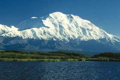
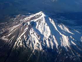
1. Mount McKinley, or Denali, is the highest peak of greater North America.
-

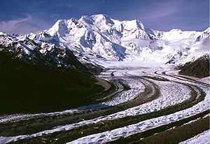
2. Mount Logan in Yukon is the highest peak of Canada.
-
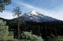
3. Pico de Orizaba is the highest peak of Mexico.
-
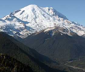
4. Mount Rainier in Washington is highest peak of the Cascade Range.
-
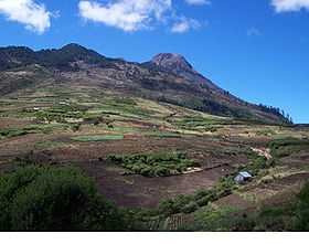
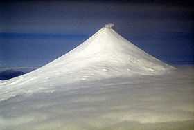
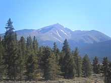
5. Volcán Tajumulco in Guatemala is the highest peak of Central America.
-

6. Mount Fairweather lies on the international boundary between Alaska and British Columbia.
-
7. Cerro Chirripó is the highest peak of Costa Rica.
-

8. Gunnbjørn Fjeld on Greenland is the highest peak of the Arctic.
-
9. Mount Blackburn is the highest peak of the Wrangell Mountains of Alaska.
-

11. Mount Saint Elias is the second highest peak of both Canada and the United States.
-

12. Mount Waddington in British Columbia is the highest peak of the Coast Mountains.
-
14. Pico Duarte on Hispaniola is the highest peak of the Caribbean.
-
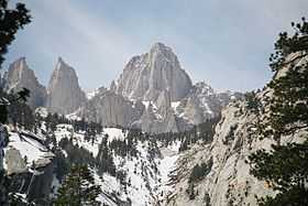
16. Mount Whitney in California is the highest peak of the contiguous United States.
-

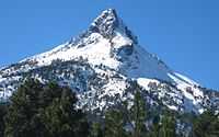
17. Popocatépetl is the second highest peak of Mexico.
-
18. Mount Shasta in California is the highest peak of the southern Cascade Range.
-
20. Mount Shishaldin on Unimak Island is the highest peak of the Aleutian Islands.
-
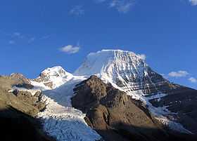
21. Mount Robson in British Columbia is the highest peak of the Canadian Rockies.
-
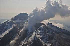
22. Redoubt Volcano is the highest peak of the Alaskan Peninsula.
-
23. Mount Elbert in Colorado is the highest peak of the Rocky Mountains.
-
25. Nevado de Colima is the highest peak of Jalisco.
See also
- Outline of North America
- Lists of mountains
- Mountain peaks of North America
- The 200 highest major summits of North America
- The 200 most prominent summits of North America
- The 355 ultra-prominent summits of North America
- The 200 most isolated major summits of North America
- The 234 major 100 km summits of North America
- Mountain peaks of Greenland
- Mountain peaks of Canada
- Mountain peaks of the Rocky Mountains
- Mountain peaks of the United States
- Mountain peaks of Alaska
- Mountain peaks of California
- Mountain peaks of Colorado
- Mountain peaks of Hawaii
- Mountain peaks of México
- Mountain peaks of Central America
- Mountain peaks of the Caribbean
- North America
- Geography of North America
- Category:Mountains of North America
- Geography of North America
- Physical geography
- Topography
- Topographic elevation
- Topographic isolation
- Topographic prominence
- Topographic summit
- Topography
References
- ↑ Mount McKinley is the highest point of the Alaska Range, the State of Alaska, the United States of America, and all of North America
- ↑ "Mount McKinley". Summits of the World. peakbagger.com. Retrieved January 27, 2010.
- ↑ Mount Logan is the highest point of the Saint Elias Mountains, the Yukon Territory, and all of Canada
- ↑ "Mount Logan". Summits of the World. peakbagger.com. Retrieved January 11, 2010.
- ↑ Volcán Citlaltépetl is the highest point of Estado Libre y Soberano de Puebla, Estado Libre y Soberano de Veracruz de Ignacio de la Llave, and all of México
- ↑ "Volcán Citlaltépetl". Summits of the World. peakbagger.com. Retrieved January 2, 2010.
- ↑ Mount Rainier is the highest point of the Cascade Range and the State of Washington
- ↑ "Mount Rainier". NGS Station Datasheet. United States National Geodetic Survey. Retrieved January 27, 2010.
- ↑ "Mount Rainier". Summits of the World. peakbagger.com. Retrieved January 27, 2010.
- ↑ The elevation of Mount Rainier includes an adjustment of +1.935 m (+6.35 ft) from NGVD 29 to NAVD 88.
- ↑ Volcán Tajumulco is the highest point of the Republic of Guatemala and all of Central America. Volcán Tajumulco is the southernmost and easternmost 4000 m (13,123-foot) summit of North America
- ↑ "Volcán Tajumulco". Summits of the World. peakbagger.com. Retrieved January 11, 2010.
- ↑ Mount Fairweather on the border of Alaska is the highest point of the Province of British Columbia
- ↑ "Mount Fairweather". Summits of the World. peakbagger.com. Retrieved January 11, 2010.
- ↑ Chirripó Grande is the highest point of the Republic of Costa Rica
- ↑ "Chirripó Grande". Summits of the World. peakbagger.com. Retrieved January 4, 2010.
- ↑ Gunnbjørn Fjeld is the highest point on the Island of Greenland, Kalaallit Nunaat, the Kingdom of Denmark, and the entire Arctic
- ↑ "Gunnbjørn Fjeld". Summits of the World. peakbagger.com. Retrieved January 2, 2010.
- ↑ "Mount Blackburn". NGS Station Datasheet. United States National Geodetic Survey. Retrieved January 11, 2010.
- ↑ "Mount Blackburn". Summits of the World. peakbagger.com. Retrieved January 11, 2010.
- ↑ Mount Hayes is the northernmost 4000 m (13,123-foot) summit of North America
- ↑ "Mount Hayes". NGS Station Datasheet. United States National Geodetic Survey. Retrieved January 27, 2010.
- ↑ "Mount Hayes". Summits of the World. peakbagger.com. Retrieved January 27, 2010.
- ↑ Mount Saint Elias on the international border between Alaska and the Yukon is the second highest mountain peak of both Canada and the United States
- ↑ "Mount Saint Elias". Summits of the World. peakbagger.com. Retrieved January 11, 2010.
- ↑ Mount Waddington is the easternmost 4000 m (13,123-foot) summit of Canada
- ↑ "Mount Waddington". Summits of the World. peakbagger.com. Retrieved January 25, 2010.
- ↑ "Mount Marcus Baker". Summits of the World. peakbagger.com. Retrieved January 27, 2010.
- ↑ Pico Duarte is the highest point on the Island of Hispaniola, the Dominican Republic, and all the islands of the Caribbean Sea
- ↑ "Pico Duarte". Summits of the World. peakbagger.com. Retrieved January 2, 2010.
- ↑ "Mount Lucania". Summits of the World. peakbagger.com. Retrieved January 11, 2010.
- ↑ Mount Whitney is the highest point of the Sierra Nevada, the State of California, and the contiguous United States
- ↑ "Mount Whitney". NGS Station Datasheet. United States National Geodetic Survey. Retrieved January 17, 2010.
- ↑ "Mount Whitney". Summits of the World. peakbagger.com. Retrieved January 17, 2010.
- ↑ The elevation of Mount Whitney includes an adjustment of +1.869 m (+6.13 ft) from NGVD 29 to NAVD 88.
- ↑ Volcán Popocatépetl on the border of Estado Libre y Soberano de Puebla is the highest point of both Estado Libre y Soberano de México and Estado Libre y Soberano de Morelos.
- ↑ "Volcán Popocatépetl". Summits of the World. peakbagger.com. Retrieved January 2, 2010.
- ↑ "Mount Shasta". NGS Station Datasheet. United States National Geodetic Survey. Retrieved January 17, 2010.
- ↑ "Mount Shasta". Summits of the World. peakbagger.com. Retrieved January 17, 2010.
- ↑ The elevation of Mount Shasta includes an adjustment of +1.791 m (+5.88 ft) from NGVD 29 to NAVD 88.
- ↑ "Monarch Mountain". Summits of the World. peakbagger.com. Retrieved January 25, 2010.
- ↑ Shishaldin Volcano is the highest point of Unimak Island and the Aleutian Islands
- ↑ "Shishaldin Volcano". Summits of the World. peakbagger.com. Retrieved January 2, 2010.
- ↑ Mount Robson is the highest point of the Canadian Rockies
- ↑ "Mount Robson". Summits of the World. peakbagger.com. Retrieved January 25, 2010.
- ↑ "Redoubt Volcano". NGS Station Datasheet. United States National Geodetic Survey. Retrieved January 2, 2010.
- ↑ "Redoubt Volcano". Summits of the World. peakbagger.com. Retrieved January 2, 2010.
- ↑ Mount Elbert is the highest point of the Rocky Mountains and the State of Colorado
- ↑ "Mount Elbert". NGS Station Datasheet. United States National Geodetic Survey. Retrieved January 17, 2010.
- ↑ "Mount Elbert". Summits of the World. peakbagger.com. Retrieved January 17, 2010.
- ↑ The elevation of Mount Elbert includes an adjustment of +1.995 m (+6.55 ft) from NGVD 29 to NAVD 88.
- ↑ "Mount Sir Wilfrid Laurier". Summits of the World. peakbagger.com. Retrieved January 25, 2010.
- ↑ Nevado de Colima is the highest point of Estado Libre y Soberano de Jalisco
- ↑ "Nevado de Colima". Summits of the World. peakbagger.com. Retrieved January 2, 2010.
- ↑ "Mount Vancouver". Summits of the World. peakbagger.com. Retrieved January 25, 2010.
- ↑ "Mount Sir Sandford". Summits of the World. peakbagger.com. Retrieved January 25, 2010.
- ↑ "Mount Baker". Summits of the World. peakbagger.com. Retrieved January 27, 2010.
- ↑ The elevation of Mount Baker includes an adjustment of +1.43 m (+4.69 ft) from NGVD 29 to NAVD 88.
- ↑ Pic la Selle is the highest point of the Republic of Haiti
- ↑ "Pic la Selle". Summits of the World. peakbagger.com. Retrieved January 2, 2010.
- ↑ "Mount Torbert". Summits of the World. peakbagger.com. Retrieved January 27, 2010.
- ↑ Barbeau Peak is the highest point of Ellesmere Island and the Nunavut Territory
- ↑ "Barbeau Peak". Summits of the World. peakbagger.com. Retrieved January 25, 2010.
- ↑ "San Jacinto Peak". NGS Station Datasheet. United States National Geodetic Survey. Retrieved January 17, 2010.
- ↑ "San Jacinto Peak". Summits of the World. peakbagger.com. Retrieved January 17, 2010.
- ↑ The elevation of San Jacinto Peak includes an adjustment of +1.107 m (+3.63 ft) from NGVD 29 to NAVD 88.
- ↑ "San Gorgonio Mountain". Summits of the World. peakbagger.com. Retrieved January 28, 2010.
- ↑ The elevation of San Gorgonio Mountain includes an adjustment of +1.303 m (+4.27 ft) from NGVD 29 to NAVD 88.
- ↑ "Charleston Peak". NGS Station Datasheet. United States National Geodetic Survey. Retrieved January 2, 2010.
- ↑ "Charleston Peak". Summits of the World. peakbagger.com. Retrieved January 2, 2010.
- ↑ The elevation of Charleston Peak includes an adjustment of +1.25 m (+4.10 ft) from NGVD 29 to NAVD 88.
- ↑ "Pavlof Volcano". NGS Station Datasheet. United States National Geodetic Survey. Retrieved January 2, 2010.
- ↑ "Pavlof Volcano". Summits of the World. peakbagger.com. Retrieved January 2, 2010.
- ↑ "Mount Veniaminof". NGS Station Datasheet. United States National Geodetic Survey. Retrieved January 27, 2010.
- ↑ "Mount Veniaminof". Summits of the World. peakbagger.com. Retrieved January 27, 2010.
- ↑ "Mount Adams". NGS Station Datasheet. United States National Geodetic Survey. Retrieved January 17, 2010.
- ↑ "Mount Adams". Summits of the World. peakbagger.com. Retrieved January 17, 2010.
- ↑ The elevation of Mount Adams includes an adjustment of +1.655 m (+5.43 ft) from NGVD 29 to NAVD 88.
- ↑ "Skihist Mountain". Summits of the World. peakbagger.com. Retrieved January 25, 2010.
- ↑ "Mount Hubbard". Summits of the World. peakbagger.com. Retrieved January 25, 2010.
- ↑ "Mount Ratz". Summits of the World. peakbagger.com. Retrieved January 26, 2010.
- ↑ "Mount Chamberlin". NGS Station Datasheet. United States National Geodetic Survey. Retrieved January 2, 2010.
- ↑ "Mount Chamberlin". Summits of the World. peakbagger.com. Retrieved January 2, 2010.
- ↑ 84.0 84.1 "Mount Odin". Summits of the World. peakbagger.com. Retrieved January 26, 2010.
- ↑ "Mount Monashee". Summits of the World. peakbagger.com. Retrieved January 26, 2010.
- ↑ "Iliamna Volcano". Summits of the World. peakbagger.com. Retrieved January 2, 2010.
- ↑ "Mount Olympus". NGS Station Datasheet. United States National Geodetic Survey. Retrieved January 17, 2010.
- ↑ "Mount Olympus". Summits of the World. peakbagger.com. Retrieved January 17, 2010.
- ↑ The elevation of Mount Olympus includes an adjustment of +1.338 m (+4.39 ft) from NGVD 29 to NAVD 88.
- ↑ Mount Columbia on the border of British Columbia is the highest point of the Province of Alberta
- ↑ "Mount Columbia". Summits of the World. peakbagger.com. Retrieved January 2, 2010.
- ↑ "Mount Queen Bess". Summits of the World. peakbagger.com. Retrieved January 26, 2010.
- ↑ "Mount Cook". Summits of the World. peakbagger.com. Retrieved January 26, 2010.
- ↑ Mount Hood is the highest point of the state of Oregon
- ↑ "Mount Hood". NGS Station Datasheet. United States National Geodetic Survey. Retrieved January 17, 2010.
- ↑ "Mount Hood". Summits of the World. peakbagger.com. Retrieved January 17, 2010.
- ↑ The elevation of Mount Hood includes an adjustment of +1.341 m (+4.40 ft) from NGVD 29 to NAVD 88.
- ↑ "Mount Sanford". Summits of the World. peakbagger.com. Retrieved January 27, 2010.
- ↑ "Mount Tom White". NGS Station Datasheet. United States National Geodetic Survey. Retrieved January 27, 2010.
- ↑ "Mount Tom White". Summits of the World. peakbagger.com. Retrieved January 27, 2010.
- ↑ "Mount Cooper". Summits of the World. peakbagger.com. Retrieved January 26, 2010.
- ↑ "Wheeler Peak". NGS Station Datasheet. United States National Geodetic Survey. Retrieved January 17, 2010.
- ↑ "Wheeler Peak". Summits of the World. peakbagger.com. Retrieved January 17, 2010.
- ↑ The elevation of Wheeler Peak includes an adjustment of +1.649 m (+5.41 ft) from NGVD 29 to NAVD 88.
- ↑ "Ulysses Mountain". Summits of the World. peakbagger.com. Retrieved January 26, 2010.
- ↑ "Glacier Peak". NGS Station Datasheet. United States National Geodetic Survey. Retrieved January 17, 2010.
- ↑ "Glacier Peak". Summits of the World. peakbagger.com. Retrieved January 17, 2010.
- ↑ The elevation of Glacier Peak includes an adjustment of +1.492 m (+4.90 ft) from NGVD 29 to NAVD 88.
- ↑ "Mount Kimball". Summits of the World. peakbagger.com. Retrieved January 27, 2010.
- ↑ Blue Mountain Peak is the highest point of the Island of Jamaica and the nation of Jamaica
- ↑ "Blue Mountain Peak". Summits of the World. peakbagger.com. Retrieved January 2, 2010.
- ↑ "Wedge Mountain". Summits of the World. peakbagger.com. Retrieved January 25, 2010.
- ↑ "Otter Mountain". Summits of the World. peakbagger.com. Retrieved January 28, 2010.
- ↑ "Mount Griggs". Summits of the World. peakbagger.com. Retrieved January 27, 2010.
- ↑ "Nevado de Toluca". Summits of the World. peakbagger.com. Retrieved January 2, 2010.
- ↑ "Kwatna Peak". Summits of the World. peakbagger.com. Retrieved January 25, 2010.
- ↑ Outlook Peak is the highest point of Axel Heiberg Island
- ↑ "Outlook Peak". Summits of the World. peakbagger.com. Retrieved January 25, 2010.
- ↑ Mount Foraker is the westernmost 5000 m (16,404-foot) summit of North America
- ↑ "Mount Foraker". NGS Station Datasheet. United States National Geodetic Survey. Retrieved January 27, 2010.
- ↑ "Mount Foraker". Summits of the World. peakbagger.com. Retrieved January 27, 2010.
- ↑ "Milne Land High Point". Summits of the World. peakbagger.com. Retrieved January 27, 2010.
- ↑ Golden Hinde is the highest point of Vancouver Island
- ↑ "Golden Hinde". Summits of the World. peakbagger.com. Retrieved January 25, 2010.
- ↑ "White Mountain Peak". NGS Station Datasheet. United States National Geodetic Survey. Retrieved January 17, 2010.
- ↑ "White Mountain Peak". Summits of the World. peakbagger.com. Retrieved January 17, 2010.
- ↑ The elevation of White Mountain Peak includes an adjustment of +1.91 m (+6.27 ft) from NGVD 29 to NAVD 88.
- ↑ "Mount Crillon". NGS Station Datasheet. United States National Geodetic Survey. Retrieved January 27, 2010.
- ↑ "Mount Crillon". Summits of the World. peakbagger.com. Retrieved January 27, 2010.
- ↑ "Stauning Alper". Summits of the World. peakbagger.com. Retrieved January 2, 2010.
- ↑ Cerro Tiotepec is the highest point of Estado Libre y Soberano de Guerrero
- ↑ "Cerro Tiotepec". Summits of the World. peakbagger.com. Retrieved January 10, 2010.
- ↑ "Scud Peak". Summits of the World. peakbagger.com. Retrieved January 28, 2010.
- ↑ "Keele Peak". Summits of the World. peakbagger.com. Retrieved January 25, 2010.
- ↑ "Cloud Peak". NGS Station Datasheet. United States National Geodetic Survey. Retrieved January 17, 2010.
- ↑ "Cloud Peak". Summits of the World. peakbagger.com. Retrieved January 17, 2010.
- ↑ The elevation of Cloud Peak includes an adjustment of +1.293 m (+4.24 ft) from NGVD 29 to NAVD 88.
- ↑ Gannett Peak is the highest point of the Central Rocky Mountains and the State of Wyoming
- ↑ "Gannett Peak". NGS Station Datasheet. United States National Geodetic Survey. Retrieved January 17, 2010.
- ↑ "Gannett Peak". Summits of the World. peakbagger.com. Retrieved January 17, 2010.
- ↑ The elevation of Gannett Peak includes an adjustment of +1.737 m (+5.70 ft) from NGVD 29 to NAVD 88.
- ↑ "Razorback Mountain". Summits of the World. peakbagger.com. Retrieved January 25, 2010.
- ↑ Mount Vsevidof is the highest point of Umnak Island
- ↑ "Mount Vsevidof". NGS Station Datasheet. United States National Geodetic Survey. Retrieved January 27, 2010.
- ↑ "Mount Vsevidof". Summits of the World. peakbagger.com. Retrieved January 27, 2010.
- ↑ Mount Odin is the highest point of Baffin Island
- ↑ "Cerro El Nacimiento". Summits of the World. peakbagger.com. Retrieved January 10, 2010.
- ↑ Picacho del Diablo is the highest point of Estado Libre y Soberano de Baja California
- ↑ "Picacho del Diablo". Summits of the World. peakbagger.com. Retrieved January 10, 2010.
- ↑ Cerro Nube is the highest point of the Sierra Madre del Sur and Estado Libre y Soberano de Oaxaca
- ↑ "Cerro Nube". Summits of the World. peakbagger.com. Retrieved January 10, 2010.
- ↑ "Mount Hesperus". Summits of the World. peakbagger.com. Retrieved January 2, 2010.
- ↑ "Mount Farnham". Summits of the World. peakbagger.com. Retrieved January 28, 2010.
- ↑ "Palup Qaqa". Summits of the World. peakbagger.com. Retrieved January 29, 2010.
- ↑ "Mount Bona". NGS Station Datasheet. United States National Geodetic Survey. Retrieved January 27, 2010.
- ↑ "Mount Bona". Summits of the World. peakbagger.com. Retrieved January 27, 2010.
- ↑ "Oscar Peak". Summits of the World. peakbagger.com. Retrieved January 25, 2010.
- ↑ "Pic Macaya". Summits of the World. peakbagger.com. Retrieved January 2, 2010.
- ↑ "Montaña de Santa Bárbara". Summits of the World. peakbagger.com. Retrieved January 29, 2010.
- ↑ "Mount Assiniboine". Summits of the World. peakbagger.com. Retrieved January 28, 2010.
- ↑ "Mount Jancowski". Summits of the World. peakbagger.com. Retrieved January 2, 2010.
- ↑ Cerro Las Minas is the highest point of the Republic of Honduras
- ↑ "Cerro Las Minas". Summits of the World. peakbagger.com. Retrieved January 3, 2010.
- ↑ "Mount Drum". Summits of the World. peakbagger.com. Retrieved January 27, 2010.
- ↑ "Gladsheim Peak". Summits of the World. peakbagger.com. Retrieved January 2, 2010.
- ↑ "Mount Dawson". Summits of the World. peakbagger.com. Retrieved January 3, 2010.
- ↑ "Payers Tinde". Summits of the World. peakbagger.com. Retrieved January 2, 2010.
- ↑ "South Ellesmere Ice Cap High Point". Summits of the World. peakbagger.com. Retrieved January 25, 2010.
- ↑ "Mount Chiginagak". Summits of the World. peakbagger.com. Retrieved January 27, 2010.
- ↑ "Mount Edith Cavell". Summits of the World. peakbagger.com. Retrieved January 28, 2010.
- ↑ "Alsek Peak". Summits of the World. peakbagger.com. Retrieved January 28, 2010.
- ↑ "Mount Valpy". Summits of the World. peakbagger.com. Retrieved January 29, 2010.
- ↑ "Perserajoq". Summits of the World. peakbagger.com. Retrieved January 2, 2010.
- ↑ "Mount Cairnes". Summits of the World. peakbagger.com. Retrieved January 28, 2010.
- ↑ "Grand Teton". NGS Station Datasheet. United States National Geodetic Survey. Retrieved January 17, 2010.
- ↑ "Grand Teton". Summits of the World. peakbagger.com. Retrieved January 17, 2010.
- ↑ The elevation of Grand Teton includes an adjustment of +1.571 m (+5.15 ft) from NGVD 29 to NAVD 88.
- ↑ "Volcán de Agua". Summits of the World. peakbagger.com. Retrieved January 27, 2010.
- ↑ "Chatsquot Mountain". Summits of the World. peakbagger.com. Retrieved January 25, 2010.
- ↑ Pico Turquino is the highest point on the Island of Cuba and the Republic of Cuba
- ↑ "Pico Turquino". Summits of the World. peakbagger.com. Retrieved January 2, 2010.
- ↑ "Buckwell Peak". Summits of the World. peakbagger.com. Retrieved January 29, 2010.
- ↑ "Cerro Las Conchas". Summits of the World. peakbagger.com. Retrieved January 10, 2010.
- ↑ "Renland High Point". Summits of the World. peakbagger.com. Retrieved January 2, 2010.
- ↑ "Mount Priestley". Summits of the World. peakbagger.com. Retrieved January 25, 2010.
- ↑ "Angilaaq Mountain". Summits of the World. peakbagger.com. Retrieved January 2, 2010.
- ↑ "Sacajawea Peak". Summits of the World. peakbagger.com. Retrieved January 28, 2010.
- ↑ The elevation of Sacajawea Peak includes an adjustment of +1.56 m (+5.12 ft) from NGVD 29 to NAVD 88.
- ↑ "Mount Neacola". Summits of the World. peakbagger.com. Retrieved January 2, 2010.
- ↑ Volcán Matlalcuéyetl on the border of Estado Libre y Soberano de Puebla is the highest point of Estado Libre y Soberano de Tlaxcala
- ↑ "Volcán Matlalcuéyetl". Summits of the World. peakbagger.com. Retrieved January 2, 2010.
- ↑ Kings Peak (Utah) is the highest point of the Western Rocky Mountains and the State of Utah
- ↑ "Kings Peak (Utah)". NGS Station Datasheet. United States National Geodetic Survey. Retrieved January 3, 2010.
- ↑ "Kings Peak (Utah)". Summits of the World. peakbagger.com. Retrieved January 3, 2010.
- ↑ The elevation of Kings Peak (Utah) includes an adjustment of +1.794 m (+5.89 ft) from NGVD 29 to NAVD 88.
- ↑ "Mount Graham". NGS Station Datasheet. United States National Geodetic Survey. Retrieved January 17, 2010.
- ↑ "Mount Graham". Summits of the World. peakbagger.com. Retrieved January 17, 2010.
- ↑ The elevation of Mount Graham includes an adjustment of +1.036 m (+3.40 ft) from NGVD 29 to NAVD 88.
- ↑ "Mount Douglas". Summits of the World. peakbagger.com. Retrieved January 27, 2010.
- ↑ "Devon Ice Cap High Point". Summits of the World. peakbagger.com. Retrieved January 2, 2010.
- ↑ Sierra La Laguna High Point is the highest point in Estado Libre y Soberano de Baja California Sur
- ↑ "Sierra La Laguna High Point". Summits of the World. peakbagger.com. Retrieved January 2, 2010.
- ↑ "Mount Goodsir". Summits of the World. peakbagger.com. Retrieved January 28, 2010.
- ↑ "Sharks Teeth Peaks". Summits of the World. peakbagger.com. Retrieved January 2, 2010.
- ↑ "Detour Peak". Summits of the World. peakbagger.com. Retrieved January 2, 2010.
- ↑ "Sierra La Madera". Summits of the World. peakbagger.com. Retrieved January 10, 2010.
- ↑ "Qeqertarsuaq Island High Point". Summits of the World. peakbagger.com. Retrieved January 27, 2010.
- ↑ "Mount San Antonio". NGS Station Datasheet. United States National Geodetic Survey. Retrieved January 28, 2010.
- ↑ "Mount San Antonio". Summits of the World. peakbagger.com. Retrieved January 28, 2010.
- ↑ The elevation of Mount San Antonio includes an adjustment of +1.214 m (+3.98 ft) from NGVD 29 to NAVD 88.
- ↑ "Kichatna Spire". Summits of the World. peakbagger.com. Retrieved January 27, 2010.
- ↑ "De Long Peak". Summits of the World. peakbagger.com. Retrieved January 27, 2010.
- ↑ "De Long Peak". Bivouac Mountaineering Directory. bivouac.com. Retrieved January 27, 2010.
- ↑ "Angelin Bjerg". Summits of the World. peakbagger.com. Retrieved January 27, 2010.
- ↑ "Telescope Peak". NGS Station Datasheet. United States National Geodetic Survey. Retrieved January 17, 2010.
- ↑ "Telescope Peak". Summits of the World. peakbagger.com. Retrieved January 17, 2010.
- ↑ The elevation of Telescope Peak includes an adjustment of +1.169 m (+3.84 ft) from NGVD 29 to NAVD 88.
- ↑ "Cerro Tia Chena". Summits of the World. peakbagger.com. Retrieved January 3, 2010.
- ↑ "Traill Island High Point". Summits of the World. peakbagger.com. Retrieved January 3, 2010.
- ↑ "Mount Peale". NGS Station Datasheet. United States National Geodetic Survey. Retrieved January 3, 2010.
- ↑ "Mount Peale". Summits of the World. peakbagger.com. Retrieved January 3, 2010.
- ↑ The elevation of Mount Peale includes an adjustment of +1.509 m (+4.95 ft) from NGVD 29 to NAVD 88.
- ↑ Pogromni Volcano is the westernmost ultra-prominent summit of continental North America
- ↑ "Pogromni Volcano". NGS Station Datasheet. United States National Geodetic Survey. Retrieved January 2, 2010.
- ↑ "Pogromni Volcano". Summits of the World. peakbagger.com. Retrieved January 2, 2010.
- ↑ "Dewey Peak". Summits of the World. peakbagger.com. Retrieved January 27, 2010.
- ↑ "Dewey Peak". Bivouac Mountaineering Directory. bivouac.com. Retrieved January 27, 2010.
- ↑ "Alto Cuchumatanes". Summits of the World. peakbagger.com. Retrieved January 3, 2010.
- ↑ Mount Washington is the highest point of the Northern Appalachian Mountains, the State of New Hampshire, and all of northeastern North America. Mount Washington is the easternmost ultra-prominent summit of continental North America
- ↑ "Mount Washington". NGS Station Datasheet. United States National Geodetic Survey. Retrieved January 17, 2010.
- ↑ "Mount Washington". Summits of the World. peakbagger.com. Retrieved January 17, 2010.
- ↑ The elevation of Mount Washington includes an adjustment of +0.02 m (+0.07 ft) from NGVD 29 to NAVD 88.
- ↑ "Silvertip Mountain". Summits of the World. peakbagger.com. Retrieved January 27, 2010.
- ↑ "Cerro El Potosí". Summits of the World. peakbagger.com. Retrieved January 10, 2010.
- ↑ "Volcán Irazú". Summits of the World. peakbagger.com. Retrieved January 4, 2010.
- ↑ "Cerro La Joya". Summits of the World. peakbagger.com. Retrieved January 10, 2010.
- ↑ "Mount Igikpak". Summits of the World. peakbagger.com. Retrieved January 27, 2010.
- ↑ "Snow Tower". Summits of the World. peakbagger.com. Retrieved January 2, 2010.
- ↑ "Seven Sisters Peaks". Summits of the World. peakbagger.com. Retrieved January 25, 2010.
- ↑ "Montañas Peña Blanca". Summits of the World. peakbagger.com. Retrieved January 3, 2010.
- ↑ Mount Mitchell is the highest point of the Appalachian Mountains, the State of North Carolina, and all of eastern North America
- ↑ "Mount Mitchell". Summits of the World. peakbagger.com. Retrieved January 28, 2010.
- ↑ The elevation of Mount Mitchell includes an adjustment of +0.025 m (+0.08 ft) from NGVD 29 to NAVD 88.
- ↑ "Mount Saugstad". Summits of the World. peakbagger.com. Retrieved January 2, 2010.
- ↑ "Truuli Peak". Summits of the World. peakbagger.com. Retrieved January 27, 2010.
- ↑ "Victoria Peak". Summits of the World. peakbagger.com. Retrieved January 28, 2010.
- ↑ Humphreys Peak is the highest point of the State of Arizona
- ↑ "Humphreys Peak". NGS Station Datasheet. United States National Geodetic Survey. Retrieved January 28, 2010.
- ↑ "Humphreys Peak". Summits of the World. peakbagger.com. Retrieved January 28, 2010.
- ↑ The elevation of Humphreys Peak includes an adjustment of +1.345 m (+4.41 ft) from NGVD 29 to NAVD 88.
- ↑ "Volcán Acatenango". Summits of the World. peakbagger.com. Retrieved January 3, 2010.
- ↑ "Brian Boru Peak". Summits of the World. peakbagger.com. Retrieved January 2, 2010.
- ↑ "Volcán San Miguel". Summits of the World. peakbagger.com. Retrieved January 2, 2010.
- ↑ Borah Peak is the highest point of the State of Idaho
- ↑ "Borah Peak". NGS Station Datasheet. United States National Geodetic Survey. Retrieved January 28, 2010.
- ↑ "Borah Peak". Summits of the World. peakbagger.com. Retrieved January 28, 2010.
- ↑ The elevation of Borah Peak includes an adjustment of +1.682 m (+5.52 ft) from NGVD 29 to NAVD 88.
- ↑ "Howson Peak". Summits of the World. peakbagger.com. Retrieved January 25, 2010.
- ↑ "Atna Peak". Summits of the World. peakbagger.com. Retrieved January 2, 2010.
- ↑ "Tsaydaychuz Peak". Summits of the World. peakbagger.com. Retrieved January 25, 2010.
- ↑ "Mount Natazhat". Summits of the World. peakbagger.com. Retrieved January 27, 2010.
- ↑ "Parnaqussuit Qavaat High Point". Summits of the World. peakbagger.com. Retrieved January 2, 2010.
- ↑ "Hanagita Peak". NGS Station Datasheet. United States National Geodetic Survey. Retrieved January 2, 2010.
- ↑ "Hanagita Peak". Summits of the World. peakbagger.com. Retrieved January 2, 2010.
- ↑ Tanaga Volcano is the highest point of Tanaga Island
- ↑ "Tanaga Volcano". Summits of the World. peakbagger.com. Retrieved January 2, 2010.
- ↑ "Kootenay Mountain". Summits of the World. peakbagger.com. Retrieved January 2, 2010.
- ↑ Makushin Volcano is the highest point of Unalaska Island
- ↑ "Makushin Volcano". Summits of the World. peakbagger.com. Retrieved January 27, 2010.
- ↑ "Shedin Peak". Summits of the World. peakbagger.com. Retrieved January 28, 2010.
- ↑ "Mount Martha Black". Summits of the World. peakbagger.com. Retrieved January 28, 2010.
- ↑ "Sovereign Mountain". Summits of the World. peakbagger.com. Retrieved January 27, 2010.
- ↑ 273.0 273.1 "Mount Jefferson". NGS Station Datasheet. United States National Geodetic Survey. Retrieved January 17, 2010.
- ↑ 274.0 274.1 "Mount Jefferson". Summits of the World. peakbagger.com. Retrieved January 17, 2010.
- ↑ 275.0 275.1 The elevation of Mount Jefferson includes an adjustment of +1.666 m (+5.47 ft) from NGVD 29 to NAVD 88.
- ↑ "Qiajivik Mountain". Summits of the World. peakbagger.com. Retrieved January 27, 2010.
- ↑ "Mount Ellen Peak". Summits of the World. peakbagger.com. Retrieved January 28, 2010.
- ↑ The elevation of Mount Ellen Peak includes an adjustment of +1.486 m (+4.88 ft) from NGVD 29 to NAVD 88.
- ↑ "Isanotski Peaks". NGS Station Datasheet. United States National Geodetic Survey. Retrieved January 27, 2010.
- ↑ "Isanotski Peaks". Summits of the World. peakbagger.com. Retrieved January 27, 2010.
- ↑ "Birkenhead Peak". Summits of the World. peakbagger.com. Retrieved January 25, 2010.
- ↑ "Loma Gajo en Medio". Summits of the World. peakbagger.com. Retrieved January 2, 2010.
- ↑ "Deseret Peak". NGS Station Datasheet. United States National Geodetic Survey. Retrieved January 17, 2010.
- ↑ "Deseret Peak". Summits of the World. peakbagger.com. Retrieved January 17, 2010.
- ↑ The elevation of Deseret Peak includes an adjustment of +1.366 m (+4.48 ft) from NGVD 29 to NAVD 88.
- ↑ "Mount Harrison (British Columbia)". Summits of the World. peakbagger.com. Retrieved January 28, 2010.
- ↑ "Ultra-prominent summits of Greenland". peaklist.org. Retrieved February 11, 2010.
- ↑ Johannes V. Jensen Land High Point is the northernmost ultra-prominent summit on Earth
- ↑ Cerro Tacarcuna is the southernmost ultra-prominent summit of North America
- ↑ "Cerro Tacarcuna". Summits of the World. peakbagger.com. Retrieved January 4, 2010.
- ↑ "Storo Island High Point". Summits of the World. peakbagger.com. Retrieved January 3, 2010.
- ↑ "Snehaetten". Summits of the World. peakbagger.com. Retrieved January 3, 2010.
- ↑ "Mount Edziza". Summits of the World. peakbagger.com. Retrieved January 2, 2010.
- ↑ "Isthmus Peak". NGS Station Datasheet. United States National Geodetic Survey. Retrieved January 27, 2010.
- ↑ "Isthmus Peak". Summits of the World. peakbagger.com. Retrieved January 27, 2010.
- ↑ "Mount Sir Alexander". Summits of the World. peakbagger.com. Retrieved January 28, 2010.
- ↑ "Mount Hector". Summits of the World. peakbagger.com. Retrieved January 28, 2010.
- ↑ "Chutine Peak". Summits of the World. peakbagger.com. Retrieved January 2, 2010.
- ↑ "Volcán Atitlán". Summits of the World. peakbagger.com. Retrieved January 3, 2010.
- ↑ "Frosty Peak". NGS Station Datasheet. United States National Geodetic Survey. Retrieved January 27, 2010.
- ↑ "Frosty Peak". Summits of the World. peakbagger.com. Retrieved January 27, 2010.
- ↑ "Helges Halvo High Point". Summits of the World. peakbagger.com. Retrieved January 3, 2010.
- ↑ "Whitehorn Mountain". Summits of the World. peakbagger.com. Retrieved January 28, 2010.
- ↑ "Pilot Peak". NGS Station Datasheet. United States National Geodetic Survey. Retrieved January 3, 2010.
- ↑ "Pilot Peak". Summits of the World. peakbagger.com. Retrieved January 3, 2010.
- ↑ The elevation of Pilot Peak includes an adjustment of +1.178 m (+3.86 ft) from NGVD 29 to NAVD 88.
- ↑ "Mount Chown". Summits of the World. peakbagger.com. Retrieved January 28, 2010.
- ↑ "Peak 08-46". Summits of the World. peakbagger.com. Retrieved January 28, 2010.
- ↑ "Crazy Peak". NGS Station Datasheet. United States National Geodetic Survey. Retrieved January 28, 2010.
- ↑ "Crazy Peak". Summits of the World. peakbagger.com. Retrieved January 28, 2010.
- ↑ The elevation of Crazy Peak includes an adjustment of +1.422 m (+4.67 ft) from NGVD 29 to NAVD 88.
- ↑ "Great Sitkin Volcano". Summits of the World. peakbagger.com. Retrieved January 27, 2010.
- ↑ "Thudaka Mountain". Summits of the World. peakbagger.com. Retrieved January 2, 2010.
- ↑ "Svedenborg Bjerg". Summits of the World. peakbagger.com. Retrieved January 27, 2010.
- ↑ Mount Cleveland is the highest point of Chuginadak Island
- ↑ "Mount Cleveland". NGS Station Datasheet. United States National Geodetic Survey. Retrieved January 2, 2010.
- ↑ "Mount Cleveland". Summits of the World. peakbagger.com. Retrieved January 2, 2010.
- ↑ "Unuk Peak". Summits of the World. peakbagger.com. Retrieved January 2, 2010.
- ↑ "McDonald Peak". Summits of the World. peakbagger.com. Retrieved January 27, 2010.
- ↑ The elevation of McDonald Peak includes an adjustment of +1.318 m (+4.32 ft) from NGVD 29 to NAVD 88.
- ↑ "Cond Peak". Summits of the World. peakbagger.com. Retrieved January 2, 2010.
- ↑ "Devils Paw". Summits of the World. peakbagger.com. Retrieved January 25, 2010.
- ↑ "Mount Wrangell". Summits of the World. peakbagger.com. Retrieved January 27, 2010.
External links
- Natural Resources Canada (NRC)
- Instituto Nacional de Estadística, Geografía e Informática (INEGI) de México
- National Geodetic Survey (NGS)
- United States Geological Survey (USGS)
- Canadian Mountain Encyclopedia @ bivouac.com
- North America @ peakbagger.com
- World Mountain Encyclopedia @ peakware.com
- peaklist.org
- summitpost.org
| ||||||||||
| ||||||||||||||||||