List of the major 4000-metre summits of North America
The following sortable table lists the 124 mountain peaks of greater North America with at least 4000 meters (13,123.4 feet) of topographic elevation and at least 500 meters (1640.4 feet) of topographic prominence.
This article defines greater North America as the portion of the continental landmass of the Americas extending northward from Panama plus the islands surrounding that landmass. This article defines the islands of North America to include the coastal islands of North America, the islands of the Caribbean Sea, the Lucayan Archipelago, the Bermuda Islands, the Islands of Greenland (Kalaallit Nunaat), the islands of Northern Canada, the islands of Alaska, and the islands of the northeastern Pacific Ocean. The Hawaiian Islands are not included because they are considered part of Oceania.
Topographic elevation is the vertical distance above the reference geoid, a precise mathematical model of the Earth's sea level as an equipotential gravitational surface. Topographic prominence is the elevation difference between the summit and the highest or key col to a higher summit. Topographic isolation is the minimum great circle distance to a point of higher elevation.
This article defines a significant summit as a summit with at least 100 meters (328.1 feet) of topographic prominence, and a major summit as a summit with at least 500 meters (1640.4 feet) of topographic prominence. An ultra-prominent summit is a summit with at least 1500 meters (4921.3 feet) of topographic prominence. There are 355 ultra-prominent summits in greater North America.
All elevations in the 48 states of the contiguous United States include an elevation adjustment from the National Geodetic Vertical Datum of 1929 (NGVD 29) to the North American Vertical Datum of 1988 (NAVD 88). For further information, please see this United States National Geodetic Survey note.
Of these 124 major 4000 meter summits, 102 are located in the United States, 19 in Canada, 8 in Mexico, and 2 in Guatemala. Seven of these peaks lie on an international border.
In North America, only Mount McKinley exceeds 6000 meters (19,685 feet) elevation. Eleven major summits exceed 5000 meters (16,404.2 feet), and the following 124 major summits exceed 4000 meters (13,123.4 feet) elevation.
Table
Gallery
-
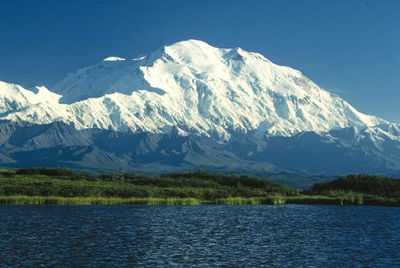
1. Mount McKinley, or Denali, is the highest peak of greater North America.
-

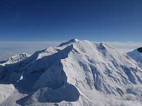
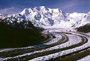
2. Mount Logan in Yukon is the highest peak of Canada.
-
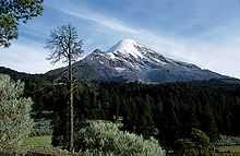
3. Pico de Orizaba is the highest peak of Mexico.
-

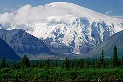
4. Mount Saint Elias is the second highest peak of both Canada and the United States.
-

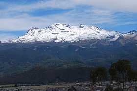
5. Popocatépetl is the second highest peak of Mexico.
-
6. Mount Foraker is the second highest major peak of the Alaska Range.
-
8. Iztaccihuatl is the third highest peak of Mexico.
-

11. Mount Steele in Yukon is the fifth highest peak of Canada.
-
12. Mount Blackburn is the highest peak of the Wrangell Mountains of Alaska.
-
13. Mount Sanford in Alaska is the third highest volcano in the United States.
-

17. Nevado de Toluca is the fourth highest peak of Mexico.
-

18. Mount Fairweather lies on the international boundary between Alaska and British Columbia.
-

23. Volcan Matlalcueitl is the sixth highest peak of Mexico.
-
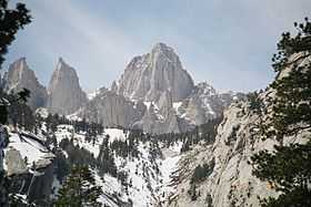
24. Mount Whitney in California is the highest peak of the contiguous United States.
-
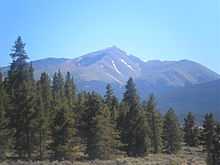
27. Mount Elbert in Colorado is the highest peak of the Rocky Mountains.
-

28. Mount Massive in Colorado is the second highest peak of the Rocky Mountains.
-
_-_2006-07-16.jpg)
29. Mount Harvard in Colorado is the highest of the Collegiate Peaks of Colorado.
-
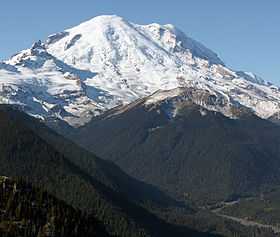
30. Mount Rainier in Washington is the most prominent peak of the contiguous United States.
-
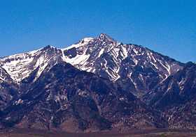
31. Mount Williamson in California is the second highest peak of the Sierra Nevada.
-

32. La Plata Peak in Colorado is the fourth highest peak of the Rocky Mountains.
See also
- Outline of North America
- Lists of mountains
- Mountain peaks of North America
- The 200 highest major summits of North America
- The 124 major 4000 metre summits of North America
- The 200 most prominent summits of North America
- The 355 ultra-prominent summits of North America
- The 200 most isolated major summits of North America
- The 234 major 100 km summits of North America
- Mountain peaks of Greenland
- Mountain peaks of Canada
- Mountain peaks of the Rocky Mountains
- Mountain peaks of the United States
- Mountain peaks of Alaska
- Mountain peaks of California
- Mountain peaks of Colorado
- Mountain peaks of Hawaii
- Mountain peaks of México
- Mountain peaks of Central America
- Mountain peaks of the Caribbean
- The 200 highest major summits of North America
- North America
- Geography of North America
- Category:Mountains of North America
- Geography of North America
- Physical geography
- Topography
- Topographic elevation
- Topographic isolation
- Topographic prominence
- Topographic summit
- Topography
References
- ↑ Mount McKinley is the highest point of the Alaska Range, the State of Alaska, the United States of America, and all of North America
- ↑ "Mount McKinley". Summits of the World. peakbagger.com. Retrieved January 27, 2010.
- ↑ Mount Logan is the highest point of the Saint Elias Mountains, the Yukon Territory, and all of Canada
- ↑ "Mount Logan". Summits of the World. peakbagger.com. Retrieved January 11, 2010.
- ↑ Volcán Citlaltépetl is the highest point of Estado Libre y Soberano de Puebla, Estado Libre y Soberano de Veracruz de Ignacio de la Llave, and all of México
- ↑ "Volcán Citlaltépetl". Summits of the World. peakbagger.com. Retrieved January 2, 2010.
- ↑ Mount Saint Elias on the international border between Alaska and the Yukon is the second highest mountain peak of both Canada and the United States
- ↑ "Mount Saint Elias". Summits of the World. peakbagger.com. Retrieved January 11, 2010.
- ↑ Volcán Popocatépetl on the border of Estado Libre y Soberano de Puebla is the highest point of both Estado Libre y Soberano de México and Estado Libre y Soberano de Morelos.
- ↑ "Volcán Popocatépetl". Summits of the World. peakbagger.com. Retrieved January 2, 2010.
- ↑ Mount Foraker is the westernmost 5000 m (16,404-foot) summit of North America
- ↑ "Mount Foraker". NGS Station Datasheet. United States National Geodetic Survey. Retrieved January 27, 2010.
- ↑ "Mount Foraker". Summits of the World. peakbagger.com. Retrieved January 27, 2010.
- ↑ "Mount Lucania". Summits of the World. peakbagger.com. Retrieved January 11, 2010.
- ↑ "Volcán Iztaccíhuatl". Summits of the World. peakbagger.com. Retrieved January 2, 2010.
- ↑ "King Peak". Summits of the World. peakbagger.com. Retrieved January 11, 2010.
- ↑ "Mount Bona". NGS Station Datasheet. United States National Geodetic Survey. Retrieved January 27, 2010.
- ↑ "Mount Bona". Summits of the World. peakbagger.com. Retrieved January 27, 2010.
- ↑ Mount Steele is the easternmost 5000 m (16,404-foot) summit of Canada
- ↑ "Mount Steele". Summits of the World. peakbagger.com. Retrieved January 25, 2010.
- ↑ "Mount Blackburn". NGS Station Datasheet. United States National Geodetic Survey. Retrieved January 11, 2010.
- ↑ "Mount Blackburn". Summits of the World. peakbagger.com. Retrieved January 11, 2010.
- ↑ "Mount Sanford". Summits of the World. peakbagger.com. Retrieved January 27, 2010.
- ↑ "Mount Wood". Summits of the World. peakbagger.com. Retrieved January 25, 2010.
- ↑ "Mount Vancouver". Summits of the World. peakbagger.com. Retrieved January 25, 2010.
- ↑ "Mount Slaggard". Summits of the World. peakbagger.com. Retrieved January 25, 2010.
- ↑ "Nevado de Toluca". Summits of the World. peakbagger.com. Retrieved January 2, 2010.
- ↑ Mount Fairweather on the border of Alaska is the highest point of the Province of British Columbia
- ↑ "Mount Fairweather". Summits of the World. peakbagger.com. Retrieved January 11, 2010.
- ↑ "Mount Hubbard". Summits of the World. peakbagger.com. Retrieved January 25, 2010.
- ↑ "Mount Bear". Summits of the World. peakbagger.com. Retrieved January 27, 2010.
- ↑ "Mount Walsh". Summits of the World. peakbagger.com. Retrieved January 25, 2010.
- ↑ "Mount Hunter". NGS Station Datasheet. United States National Geodetic Survey. Retrieved January 27, 2010.
- ↑ "Mount Hunter". Summits of the World. peakbagger.com. Retrieved January 27, 2010.
- ↑ Volcán Matlalcuéyetl on the border of Estado Libre y Soberano de Puebla is the highest point of Estado Libre y Soberano de Tlaxcala
- ↑ "Volcán Matlalcuéyetl". Summits of the World. peakbagger.com. Retrieved January 2, 2010.
- ↑ Mount Whitney is the highest point of the Sierra Nevada, the State of California, and the contiguous United States
- ↑ "Mount Whitney". NGS Station Datasheet. United States National Geodetic Survey. Retrieved January 17, 2010.
- ↑ "Mount Whitney". Summits of the World. peakbagger.com. Retrieved January 17, 2010.
- ↑ The elevation of Mount Whitney includes an adjustment of +1.869 m (+6.13 ft) from NGVD 29 to NAVD 88.
- ↑ "Mount Alverstone". Summits of the World. peakbagger.com. Retrieved January 25, 2010.
- ↑ "University Peak". Summits of the World. peakbagger.com. Retrieved January 27, 2010.
- ↑ Mount Elbert is the highest point of the Rocky Mountains and the State of Colorado
- ↑ "Mount Elbert". NGS Station Datasheet. United States National Geodetic Survey. Retrieved January 17, 2010.
- ↑ "Mount Elbert". Summits of the World. peakbagger.com. Retrieved January 17, 2010.
- ↑ The elevation of Mount Elbert includes an adjustment of +1.995 m (+6.55 ft) from NGVD 29 to NAVD 88.
- ↑ "Mount Massive". NGS Station Datasheet. United States National Geodetic Survey. Retrieved January 17, 2010.
- ↑ "Mount Massive". Summits of the World. peakbagger.com. Retrieved January 17, 2010.
- ↑ The elevation of Mount Massive includes an adjustment of +2.087 m (+6.85 ft) from NGVD 29 to NAVD 88.
- ↑ "Mount Harvard". NGS Station Datasheet. United States National Geodetic Survey. Retrieved January 17, 2010.
- ↑ "Mount Harvard". Summits of the World. peakbagger.com. Retrieved January 17, 2010.
- ↑ The elevation of Mount Harvard includes an adjustment of +2.084 m (+6.84 ft) from NGVD 29 to NAVD 88.
- ↑ The summit elevation of Mount Harvard includes a vertical offset of +1.8 m (+5.9 ft) from the benchmark.
- ↑ Mount Rainier is the highest point of the Cascade Range and the State of Washington
- ↑ "Mount Rainier". NGS Station Datasheet. United States National Geodetic Survey. Retrieved January 27, 2010.
- ↑ "Mount Rainier". Summits of the World. peakbagger.com. Retrieved January 27, 2010.
- ↑ The elevation of Mount Rainier includes an adjustment of +1.935 m (+6.35 ft) from NGVD 29 to NAVD 88.
- ↑ "Mount Williamson". Summits of the World. peakbagger.com. Retrieved January 28, 2010.
- ↑ The elevation of Mount Williamson includes an adjustment of +1.807 m (+5.93 ft) from NGVD 29 to NAVD 88.
- ↑ "McArthur Peak". Summits of the World. peakbagger.com. Retrieved January 25, 2010.
- ↑ "La Plata Peak". Summits of the World. peakbagger.com. Retrieved January 28, 2010.
- ↑ The elevation of La Plata Peak includes an adjustment of +1.983 m (+6.51 ft) from NGVD 29 to NAVD 88.
- ↑ "Blanca Peak". NGS Station Datasheet. United States National Geodetic Survey. Retrieved January 2, 2010.
- ↑ "Blanca Peak". Summits of the World. peakbagger.com. Retrieved January 2, 2010.
- ↑ The elevation of Blanca Peak includes an adjustment of +1.755 m (+5.76 ft) from NGVD 29 to NAVD 88.
- ↑ "Uncompahgre Peak". NGS Station Datasheet. United States National Geodetic Survey. Retrieved January 17, 2010.
- ↑ "Uncompahgre Peak". Summits of the World. peakbagger.com. Retrieved January 17, 2010.
- ↑ The elevation of Uncompahgre Peak includes an adjustment of +1.967 m (+6.45 ft) from NGVD 29 to NAVD 88.
- ↑ "Crestone Peak". Summits of the World. peakbagger.com. Retrieved January 2, 2010.
- ↑ The elevation of Crestone Peak includes an adjustment of +1.76 m (+5.77 ft) from NGVD 29 to NAVD 88.
- ↑ "Mount Lincoln". NGS Station Datasheet. United States National Geodetic Survey. Retrieved January 17, 2010.
- ↑ "Mount Lincoln". Summits of the World. peakbagger.com. Retrieved January 17, 2010.
- ↑ The elevation of Mount Lincoln includes an adjustment of +2.098 m (+6.88 ft) from NGVD 29 to NAVD 88.
- ↑ "Castle Peak". NGS Station Datasheet. United States National Geodetic Survey. Retrieved January 17, 2010.
- ↑ "Castle Peak". Summits of the World. peakbagger.com. Retrieved January 17, 2010.
- ↑ The elevation of Castle Peak includes an adjustment of +2.165 m (+7.10 ft) from NGVD 29 to NAVD 88.
- ↑ Grays Peak is the highest point on the Continental Divide of North America
- ↑ "Grays Peak". NGS Station Datasheet. United States National Geodetic Survey. Retrieved January 17, 2010.
- ↑ "Grays Peak". Summits of the World. peakbagger.com. Retrieved January 17, 2010.
- ↑ The elevation of Grays Peak includes an adjustment of +1.881 m (+6.17 ft) from NGVD 29 to NAVD 88.
- ↑ "Mount Antero". NGS Station Datasheet. United States National Geodetic Survey. Retrieved January 17, 2010.
- ↑ "Mount Antero". Summits of the World. peakbagger.com. Retrieved January 17, 2010.
- ↑ The elevation of Mount Antero includes an adjustment of +2.071 m (+6.79 ft) from NGVD 29 to NAVD 88.
- ↑ "Mount Evans". NGS Station Datasheet. United States National Geodetic Survey. Retrieved January 17, 2010.
- ↑ "Mount Evans". Summits of the World. peakbagger.com. Retrieved January 17, 2010.
- ↑ The elevation of Mount Evans includes an adjustment of +1.827 m (+5.99 ft) from NGVD 29 to NAVD 88.
- ↑ "Longs Peak". NGS Station Datasheet. United States National Geodetic Survey. Retrieved January 17, 2010.
- ↑ "Longs Peak". Summits of the World. peakbagger.com. Retrieved January 17, 2010.
- ↑ The elevation of Longs Peak includes an adjustment of +1.652 m (+5.42 ft) from NGVD 29 to NAVD 88.
- ↑ "Mount Wilson". Summits of the World. peakbagger.com. Retrieved January 2, 2010.
- ↑ The elevation of Mount Wilson includes an adjustment of +1.899 m (+6.23 ft) from NGVD 29 to NAVD 88.
- ↑ "White Mountain Peak". NGS Station Datasheet. United States National Geodetic Survey. Retrieved January 17, 2010.
- ↑ "White Mountain Peak". Summits of the World. peakbagger.com. Retrieved January 17, 2010.
- ↑ The elevation of White Mountain Peak includes an adjustment of +1.91 m (+6.27 ft) from NGVD 29 to NAVD 88.
- ↑ "North Palisade". NGS Station Datasheet. United States National Geodetic Survey. Retrieved January 17, 2010.
- ↑ "North Palisade". Summits of the World. peakbagger.com. Retrieved January 17, 2010.
- ↑ The elevation of North Palisade includes an adjustment of +1.867 m (+6.13 ft) from NGVD 29 to NAVD 88.
- ↑ "Mount Princeton". NGS Station Datasheet. United States National Geodetic Survey. Retrieved January 17, 2010.
- ↑ "Mount Princeton". Summits of the World. peakbagger.com. Retrieved January 17, 2010.
- ↑ The elevation of Mount Princeton includes an adjustment of +2.075 m (+6.81 ft) from NGVD 29 to NAVD 88.
- ↑ "Mount Yale". NGS Station Datasheet. United States National Geodetic Survey. Retrieved January 17, 2010.
- ↑ "Mount Yale". Summits of the World. peakbagger.com. Retrieved January 17, 2010.
- ↑ The elevation of Mount Yale includes an adjustment of +2.036 m (+6.68 ft) from NGVD 29 to NAVD 88.
- ↑ The summit elevation of Mount Yale includes a vertical offset of +0.6 m (+2.0 ft) from the benchmark.
- ↑ "Mount Shasta". NGS Station Datasheet. United States National Geodetic Survey. Retrieved January 17, 2010.
- ↑ "Mount Shasta". Summits of the World. peakbagger.com. Retrieved January 17, 2010.
- ↑ The elevation of Mount Shasta includes an adjustment of +1.791 m (+5.88 ft) from NGVD 29 to NAVD 88.
- ↑ "Maroon Peak". NGS Station Datasheet. United States National Geodetic Survey. Retrieved January 17, 2010.
- ↑ "Maroon Peak". Summits of the World. peakbagger.com. Retrieved January 17, 2010.
- ↑ The elevation of Maroon Peak includes an adjustment of +2.048 m (+6.72 ft) from NGVD 29 to NAVD 88.
- ↑ "Mount Wrangell". Summits of the World. peakbagger.com. Retrieved January 27, 2010.
- ↑ "Mount Sneffels". NGS Station Datasheet. United States National Geodetic Survey. Retrieved January 17, 2010.
- ↑ "Mount Sneffels". Summits of the World. peakbagger.com. Retrieved January 17, 2010.
- ↑ The elevation of Mount Sneffels includes an adjustment of +1.879 m (+6.16 ft) from NGVD 29 to NAVD 88.
- ↑ "Capitol Peak". NGS Station Datasheet. United States National Geodetic Survey. Retrieved January 17, 2010.
- ↑ "Capitol Peak". Summits of the World. peakbagger.com. Retrieved January 17, 2010.
- ↑ The elevation of Capitol Peak includes an adjustment of +1.991 m (+6.53 ft) from NGVD 29 to NAVD 88.
- ↑ "Pikes Peak". NGS Station Datasheet. United States National Geodetic Survey. Retrieved January 17, 2010.
- ↑ "Pikes Peak". Summits of the World. peakbagger.com. Retrieved January 17, 2010.
- ↑ The elevation of Pikes Peak includes an adjustment of +1.678 m (+5.51 ft) from NGVD 29 to NAVD 88.
- ↑ "Mount Eolus". Summits of the World. peakbagger.com. Retrieved January 28, 2010.
- ↑ The elevation of Mount Eolus includes an adjustment of +1.756 m (+5.76 ft) from NGVD 29 to NAVD 88.
- ↑ "Mount Augusta". Summits of the World. peakbagger.com. Retrieved January 26, 2010.
- ↑ "Handies Peak". NGS Station Datasheet. United States National Geodetic Survey. Retrieved January 17, 2010.
- ↑ "Handies Peak". Summits of the World. peakbagger.com. Retrieved January 17, 2010.
- ↑ The elevation of Handies Peak includes an adjustment of +1.994 m (+6.54 ft) from NGVD 29 to NAVD 88.
- ↑ "Culebra Peak". Summits of the World. peakbagger.com. Retrieved January 2, 2010.
- ↑ The elevation of Culebra Peak includes an adjustment of +1.74 m (+5.71 ft) from NGVD 29 to NAVD 88.
- ↑ "San Luis Peak". NGS Station Datasheet. United States National Geodetic Survey. Retrieved January 17, 2010.
- ↑ "San Luis Peak". Summits of the World. peakbagger.com. Retrieved January 17, 2010.
- ↑ The elevation of San Luis Peak includes an adjustment of +2.098 m (+6.88 ft) from NGVD 29 to NAVD 88.
- ↑ "Mount of the Holy Cross". NGS Station Datasheet. United States National Geodetic Survey. Retrieved January 17, 2010.
- ↑ "Mount of the Holy Cross". Summits of the World. peakbagger.com. Retrieved January 17, 2010.
- ↑ The elevation of Mount of the Holy Cross includes an adjustment of +1.926 m (+6.32 ft) from NGVD 29 to NAVD 88.
- ↑ Nevado de Colima is the highest point of Estado Libre y Soberano de Jalisco
- ↑ "Nevado de Colima". Summits of the World. peakbagger.com. Retrieved January 2, 2010.
- ↑ "Grizzly Peak". NGS Station Datasheet. United States National Geodetic Survey. Retrieved January 17, 2010.
- ↑ "Grizzly Peak". Summits of the World. peakbagger.com. Retrieved January 17, 2010.
- ↑ The elevation of Grizzly Peak includes an adjustment of +2.035 m (+6.68 ft) from NGVD 29 to NAVD 88.
- ↑ "Mount Humphreys". NGS Station Datasheet. United States National Geodetic Survey. Retrieved January 17, 2010.
- ↑ "Mount Humphreys". Summits of the World. peakbagger.com. Retrieved January 17, 2010.
- ↑ The elevation of Mount Humphreys includes an adjustment of +1.842 m (+6.04 ft) from NGVD 29 to NAVD 88.
- ↑ "Mount Keith". NGS Station Datasheet. United States National Geodetic Survey. Retrieved January 17, 2010.
- ↑ "Mount Keith". Summits of the World. peakbagger.com. Retrieved January 17, 2010.
- ↑ The elevation of Mount Keith includes an adjustment of +1.795 m (+5.89 ft) from NGVD 29 to NAVD 88.
- ↑ "Mount Strickland". Summits of the World. peakbagger.com. Retrieved January 27, 2010.
- ↑ "Mount Ouray". NGS Station Datasheet. United States National Geodetic Survey. Retrieved January 17, 2010.
- ↑ "Mount Ouray". Summits of the World. peakbagger.com. Retrieved January 17, 2010.
- ↑ The elevation of Mount Ouray includes an adjustment of +1.871 m (+6.14 ft) from NGVD 29 to NAVD 88.
- ↑ "Vermilion Peak". Summits of the World. peakbagger.com. Retrieved January 28, 2010.
- ↑ The elevation of Vermilion Peak includes an adjustment of +1.827 m (+5.99 ft) from NGVD 29 to NAVD 88.
- ↑ "Avalanche Peak". Summits of the World. peakbagger.com. Retrieved January 28, 2010.
- ↑ "Atna Peaks". Summits of the World. peakbagger.com. Retrieved January 27, 2010.
- ↑ Volcán Tajumulco is the highest point of the Republic of Guatemala and all of Central America. Volcán Tajumulco is the southernmost and easternmost 4000 m (13,123-foot) summit of North America
- ↑ "Volcán Tajumulco". Summits of the World. peakbagger.com. Retrieved January 11, 2010.
- ↑ "Regal Mountain". NGS Station Datasheet. United States National Geodetic Survey. Retrieved January 27, 2010.
- ↑ "Regal Mountain". Summits of the World. peakbagger.com. Retrieved January 27, 2010.
- ↑ "Mount Darwin". NGS Station Datasheet. United States National Geodetic Survey. Retrieved January 17, 2010.
- ↑ "Mount Darwin". Summits of the World. peakbagger.com. Retrieved January 17, 2010.
- ↑ The elevation of Mount Darwin includes an adjustment of +1.886 m (+6.19 ft) from NGVD 29 to NAVD 88.
- ↑ Mount Hayes is the northernmost 4000 m (13,123-foot) summit of North America
- ↑ "Mount Hayes". NGS Station Datasheet. United States National Geodetic Survey. Retrieved January 27, 2010.
- ↑ "Mount Hayes". Summits of the World. peakbagger.com. Retrieved January 27, 2010.
- ↑ "Mount Silverheels". NGS Station Datasheet. United States National Geodetic Survey. Retrieved January 17, 2010.
- ↑ "Mount Silverheels". Summits of the World. peakbagger.com. Retrieved January 17, 2010.
- ↑ The elevation of Mount Silverheels includes an adjustment of +1.982 m (+6.50 ft) from NGVD 29 to NAVD 88.
- ↑ "Rio Grande Pyramid". NGS Station Datasheet. United States National Geodetic Survey. Retrieved January 17, 2010.
- ↑ "Rio Grande Pyramid". Summits of the World. peakbagger.com. Retrieved January 17, 2010.
- ↑ The elevation of Rio Grande Pyramid includes an adjustment of +1.801 m (+5.91 ft) from NGVD 29 to NAVD 88.
- ↑ Gannett Peak is the highest point of the Central Rocky Mountains and the State of Wyoming
- ↑ "Gannett Peak". NGS Station Datasheet. United States National Geodetic Survey. Retrieved January 17, 2010.
- ↑ "Gannett Peak". Summits of the World. peakbagger.com. Retrieved January 17, 2010.
- ↑ The elevation of Gannett Peak includes an adjustment of +1.737 m (+5.70 ft) from NGVD 29 to NAVD 88.
- ↑ "Mount Kaweah". Summits of the World. peakbagger.com. Retrieved January 28, 2010.
- ↑ The elevation of Mount Kaweah includes an adjustment of +1.652 m (+5.42 ft) from NGVD 29 to NAVD 88.
- ↑ "Volcán Cofre de Perote". Summits of the World. peakbagger.com. Retrieved January 2, 2010.
- ↑ "Grand Teton". NGS Station Datasheet. United States National Geodetic Survey. Retrieved January 17, 2010.
- ↑ "Grand Teton". Summits of the World. peakbagger.com. Retrieved January 17, 2010.
- ↑ The elevation of Grand Teton includes an adjustment of +1.571 m (+5.15 ft) from NGVD 29 to NAVD 88.
- ↑ "Mount Cook". Summits of the World. peakbagger.com. Retrieved January 26, 2010.
- ↑ "Mount Morgan". NGS Station Datasheet. United States National Geodetic Survey. Retrieved January 17, 2010.
- ↑ "Mount Morgan". Summits of the World. peakbagger.com. Retrieved January 17, 2010.
- ↑ The elevation of Mount Morgan includes an adjustment of +1.853 m (+6.08 ft) from NGVD 29 to NAVD 88.
- ↑ "Mount Gabb". Summits of the World. peakbagger.com. Retrieved January 28, 2010.
- ↑ The elevation of Mount Gabb includes an adjustment of +1.958 m (+6.42 ft) from NGVD 29 to NAVD 88.
- ↑ "Bald Mountain". Summits of the World. peakbagger.com. Retrieved January 28, 2010.
- ↑ The elevation of Bald Mountain includes an adjustment of +1.922 m (+6.31 ft) from NGVD 29 to NAVD 88.
- ↑ "Mount Oso". Summits of the World. peakbagger.com. Retrieved September 20, 2010.
- ↑ The elevation of Mount Oso includes an adjustment of +1.776 m (+5.83 ft) from NGVD 29 to NAVD 88.
- ↑ "Mount Jackson". NGS Station Datasheet. United States National Geodetic Survey. Retrieved January 17, 2010.
- ↑ "Mount Jackson". Summits of the World. peakbagger.com. Retrieved January 17, 2010.
- ↑ The elevation of Mount Jackson includes an adjustment of +1.922 m (+6.31 ft) from NGVD 29 to NAVD 88.
- ↑ "Mount Tom". Summits of the World. peakbagger.com. Retrieved January 28, 2010.
- ↑ The elevation of Mount Tom includes an adjustment of +1.796 m (+5.89 ft) from NGVD 29 to NAVD 88.
- ↑ "Bard Peak". Summits of the World. peakbagger.com. Retrieved January 28, 2010.
- ↑ The elevation of Bard Peak includes an adjustment of +1.707 m (+5.60 ft) from NGVD 29 to NAVD 88.
- ↑ West Spanish Peak is the easternmost 4000 m (13,123-foot) summit of the United States
- ↑ "West Spanish Peak". Summits of the World. peakbagger.com. Retrieved January 28, 2010.
- ↑ The elevation of West Spanish Peak includes an adjustment of +1.468 m (+4.82 ft) from NGVD 29 to NAVD 88.
- ↑ "Mount Powell". Summits of the World. peakbagger.com. Retrieved January 28, 2010.
- ↑ The elevation of Mount Powell includes an adjustment of +1.771 m (+5.81 ft) from NGVD 29 to NAVD 88.
- ↑ "Hagues Peak". NGS Station Datasheet. United States National Geodetic Survey. Retrieved January 17, 2010.
- ↑ "Hagues Peak". Summits of the World. peakbagger.com. Retrieved January 17, 2010.
- ↑ The elevation of Hagues Peak includes an adjustment of +1.719 m (+5.64 ft) from NGVD 29 to NAVD 88.
- ↑ "Mount Dubois". Summits of the World. peakbagger.com. Retrieved January 28, 2010.
- ↑ The elevation of Mount Dubois includes an adjustment of +1.879 m (+6.16 ft) from NGVD 29 to NAVD 88.
- ↑ "Tower Mountain". Summits of the World. peakbagger.com. Retrieved January 28, 2010.
- ↑ The elevation of Tower Mountain includes an adjustment of +1.796 m (+5.89 ft) from NGVD 29 to NAVD 88.
- ↑ "Treasure Mountain". Summits of the World. peakbagger.com. Retrieved January 28, 2010.
- ↑ The elevation of Treasure Mountain includes an adjustment of +2.008 m (+6.59 ft) from NGVD 29 to NAVD 88.
- ↑ Kings Peak (Utah) is the highest point of the Western Rocky Mountains and the State of Utah
- ↑ "Kings Peak (Utah)". NGS Station Datasheet. United States National Geodetic Survey. Retrieved January 3, 2010.
- ↑ "Kings Peak (Utah)". Summits of the World. peakbagger.com. Retrieved January 3, 2010.
- ↑ The elevation of Kings Peak (Utah) includes an adjustment of +1.794 m (+5.89 ft) from NGVD 29 to NAVD 88.
- ↑ "North Arapaho Peak". NGS Station Datasheet. United States National Geodetic Survey. Retrieved January 17, 2010.
- ↑ "North Arapaho Peak". Summits of the World. peakbagger.com. Retrieved January 17, 2010.
- ↑ The elevation of North Arapaho Peak includes an adjustment of +1.763 m (+5.78 ft) from NGVD 29 to NAVD 88.
- ↑ "Mount Pinchot". Summits of the World. peakbagger.com. Retrieved January 3, 2010.
- ↑ The elevation of Mount Pinchot includes an adjustment of +1.81 m (+5.94 ft) from NGVD 29 to NAVD 88.
- ↑ "Mount Natazhat". Summits of the World. peakbagger.com. Retrieved January 27, 2010.
- ↑ "Mount Jarvis". Summits of the World. peakbagger.com. Retrieved January 27, 2010.
- ↑ "Parry Peak". Summits of the World. peakbagger.com. Retrieved January 28, 2010.
- ↑ The elevation of Parry Peak includes an adjustment of +1.763 m (+5.78 ft) from NGVD 29 to NAVD 88.
- ↑ "Bill Williams Peak". Summits of the World. peakbagger.com. Retrieved March 16, 2013.
- ↑ The elevation of Bill Williams Peak includes an adjustment of +2.044 m (+6.71 ft) from NGVD 29 to NAVD 88.
- ↑ "Sultan Mountain". Summits of the World. peakbagger.com. Retrieved January 28, 2010.
- ↑ The elevation of Sultan Mountain includes an adjustment of +1.649 m (+5.41 ft) from NGVD 29 to NAVD 88.
- ↑ "Mount Herard". Summits of the World. peakbagger.com. Retrieved January 28, 2010.
- ↑ The elevation of Mount Herard includes an adjustment of +1.64 m (+5.38 ft) from NGVD 29 to NAVD 88.
- ↑ Volcán Tacaná on the international border with Guatemala is the highest point of Estado Libre y Soberano de Chiapas
- ↑ "Volcán Tacaná". Summits of the World. peakbagger.com. Retrieved February 1, 2012.
- ↑ "West Buffalo Peak". NGS Station Datasheet. United States National Geodetic Survey. Retrieved January 28, 2010.
- ↑ "West Buffalo Peak". Summits of the World. peakbagger.com. Retrieved January 28, 2010.
- ↑ The elevation of West Buffalo Peak includes an adjustment of +1.834 m (+6.02 ft) from NGVD 29 to NAVD 88.
- ↑ "Mount Craig". Summits of the World. peakbagger.com. Retrieved January 28, 2010.
- ↑ "Tressider Peak". Summits of the World. peakbagger.com. Retrieved January 27, 2010.
- ↑ "Summit Peak". NGS Station Datasheet. United States National Geodetic Survey. Retrieved January 17, 2010.
- ↑ "Summit Peak". Summits of the World. peakbagger.com. Retrieved January 17, 2010.
- ↑ The elevation of Summit Peak includes an adjustment of +1.877 m (+6.16 ft) from NGVD 29 to NAVD 88.
- ↑ "Dolores Peak". Summits of the World. peakbagger.com. Retrieved January 2, 2010.
- ↑ The elevation of Dolores Peak includes an adjustment of +1.8 m (+5.91 ft) from NGVD 29 to NAVD 88.
- ↑ "Antora Peak". NGS Station Datasheet. United States National Geodetic Survey. Retrieved January 28, 2010.
- ↑ "Antora Peak". Summits of the World. peakbagger.com. Retrieved January 28, 2010.
- ↑ The elevation of Antora Peak includes an adjustment of +1.884 m (+6.18 ft) from NGVD 29 to NAVD 88.
- ↑ "Henry Mountain". Summits of the World. peakbagger.com. Retrieved January 28, 2010.
- ↑ The elevation of Henry Mountain includes an adjustment of +2.037 m (+6.68 ft) from NGVD 29 to NAVD 88.
- ↑ "Hesperus Mountain". Summits of the World. peakbagger.com. Retrieved January 3, 2010.
- ↑ The elevation of Hesperus Mountain includes an adjustment of +1.65 m (+5.41 ft) from NGVD 29 to NAVD 88.
- ↑ "Mount Silverthrone". Summits of the World. peakbagger.com. Retrieved January 27, 2010.
- ↑ "Jacque Peak". Summits of the World. peakbagger.com. Retrieved January 28, 2010.
- ↑ The elevation of Jacque Peak includes an adjustment of +1.866 m (+6.12 ft) from NGVD 29 to NAVD 88.
- ↑ "Bennett Peak". Summits of the World. peakbagger.com. Retrieved January 28, 2010.
- ↑ The elevation of Bennett Peak includes an adjustment of +1.782 m (+5.85 ft) from NGVD 29 to NAVD 88.
- ↑ "Wind River Peak". NGS Station Datasheet. United States National Geodetic Survey. Retrieved January 17, 2010.
- ↑ "Wind River Peak". Summits of the World. peakbagger.com. Retrieved January 17, 2010.
- ↑ The elevation of Wind River Peak includes an adjustment of +1.587 m (+5.21 ft) from NGVD 29 to NAVD 88.
- ↑ Mount Waddington is the easternmost 4000 m (13,123-foot) summit of Canada
- ↑ "Mount Waddington". Summits of the World. peakbagger.com. Retrieved January 25, 2010.
- ↑ "Conejos Peak". NGS Station Datasheet. United States National Geodetic Survey. Retrieved January 17, 2010.
- ↑ "Conejos Peak". Summits of the World. peakbagger.com. Retrieved January 17, 2010.
- ↑ The elevation of Conejos Peak includes an adjustment of +1.792 m (+5.88 ft) from NGVD 29 to NAVD 88.
- ↑ "Mount Marcus Baker". Summits of the World. peakbagger.com. Retrieved January 27, 2010.
- ↑ "Cloud Peak". NGS Station Datasheet. United States National Geodetic Survey. Retrieved January 17, 2010.
- ↑ "Cloud Peak". Summits of the World. peakbagger.com. Retrieved January 17, 2010.
- ↑ The elevation of Cloud Peak includes an adjustment of +1.293 m (+4.24 ft) from NGVD 29 to NAVD 88.
- ↑ Wheeler Peak is the highest point of the State of New Mexico
- ↑ "Wheeler Peak". NGS Station Datasheet. United States National Geodetic Survey. Retrieved January 2, 2010.
- ↑ "Wheeler Peak". Summits of the World. peakbagger.com. Retrieved January 2, 2010.
- ↑ The elevation of Wheeler Peak includes an adjustment of +1.631 m (+5.35 ft) from NGVD 29 to NAVD 88.
- ↑ "Francs Peak". NGS Station Datasheet. United States National Geodetic Survey. Retrieved January 17, 2010.
- ↑ "Francs Peak". Summits of the World. peakbagger.com. Retrieved January 17, 2010.
- ↑ The elevation of Francs Peak includes an adjustment of +1.674 m (+5.49 ft) from NGVD 29 to NAVD 88.
- ↑ "Twilight Peak". Summits of the World. peakbagger.com. Retrieved January 28, 2010.
- ↑ The elevation of Twilight Peak includes an adjustment of +1.537 m (+5.04 ft) from NGVD 29 to NAVD 88.
- ↑ "Red Slate Mountain". NGS Station Datasheet. United States National Geodetic Survey. Retrieved January 17, 2010.
- ↑ "Red Slate Mountain". Summits of the World. peakbagger.com. Retrieved January 17, 2010.
- ↑ The elevation of Red Slate Mountain includes an adjustment of +1.893 m (+6.21 ft) from NGVD 29 to NAVD 88.
- ↑ "South River Peak". NGS Station Datasheet. United States National Geodetic Survey. Retrieved January 28, 2010.
- ↑ "South River Peak". Summits of the World. peakbagger.com. Retrieved January 28, 2010.
- ↑ The elevation of South River Peak includes an adjustment of +1.879 m (+6.16 ft) from NGVD 29 to NAVD 88.
- ↑ "Mount Ritter". Summits of the World. peakbagger.com. Retrieved January 28, 2010.
- ↑ The elevation of Mount Ritter includes an adjustment of +1.786 m (+5.86 ft) from NGVD 29 to NAVD 88.
External links
- Natural Resources Canada (NRC)
- Instituto Nacional de Estadística, Geografía e Informática (INEGI) de México
- National Geodetic Survey (NGS)
- United States Geological Survey (USGS)
- Canadian Mountain Encyclopedia @ bivouac.com
- North America @ peakbagger.com
- World Mountain Encyclopedia @ peakware.com
- peaklist.org
- summitpost.org
| ||||||||||