List of rivers of Ponce


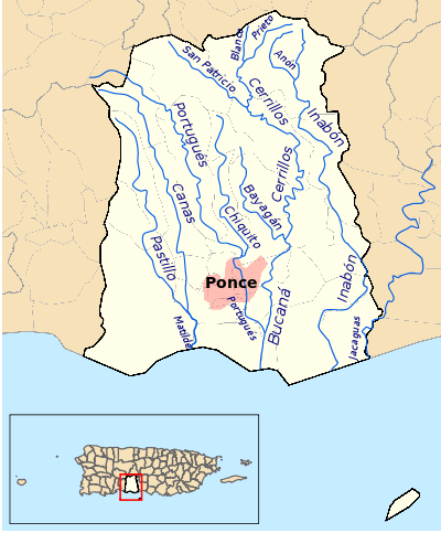
This list of rivers of Ponce consists of the 14 rivers in the municipality of Ponce, Puerto Rico. Rivers that either originate in the municipality or that run the bulk of their course through said municipality are listed. Except for two rivers, Río Portugués and Río Jacaguas, all other rivers originate and terminate within the boundaries of the municipality of Ponce. This list does not include quebradas (English: brooks). Only streams recognized as "rivers" by the United States Geological Survey and the Puerto Rico Department of Natural and Environmental Resources are included here.
All the rivers in the municipality of Ponce run into one of four river basins that then empty into the Caribbean Sea.[1] These four river basins are: Río Matilde, Río Bucaná, Río Inabón, and Río Jacaguas.
Río Pastillo and Río Canas merge to form Río Matilde. Río Blanco, Río Prieto, Río San Patricio, Río Bayagán, Río Cerrillos, Río Chiquito, and Río Portugués all run in one manner or other into Río Bucaná. Río Anon feeds into Río Inabón (Río Guayo also feeds into Río Inabón, but Río Guayo is not located in the municipality of Ponce). Río Jacaguas is actually shared between the municipalities of Ponce and Juana Díaz, as it forms the boundary between the two municipalities. Various rivers feed into Río Jacaguas, but none of them are located within the municipality of Ponce.
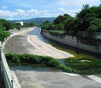
Two rivers, Río Bucaná and Río Portugués, are partially canalized. These canalization occur in parts of the urban area of the city of Ponce. Additionally, two rivers have been damed: Río Cerrillos was damed to create the Cerrillos Lake, and the daming of Río Portugués is expected to create the Portugués Lake[2] when the project is completed in 2013.[3] The daming of Río Cerrillos occurred north of the point where Río Bayagán feeds into Río Cerrillos but south of where Río San Patricio feeds into Río Cerrillos.
River list summary table
| No. | Name | Elevation at Origin (feet) | Elevation at Mouth (feet) | River Length (km) | Watershed Area (sq mi) (0= Not Applicable) | Discharge (cu ft/s) (0= Not Available) | Approximate Mouth distance from shore (km) |
|---|---|---|---|---|---|---|---|
| 1 | Río Anón | 3,854 | 1,060 | 4.0 | 0 | 0 | 12.0 |
| 2 | Río Bayagán | 141 | 42 | 9.0 | 0 | 0 | 4.0 |
| 3 | Río Blanco | 2,970 | 1,381 | 2.0 | 0 | 0 | 16.0 |
| 4 | Río Bucaná | 115 | 0 | 9.16 | 28.45 | 0 | 0 |
| 5 | Río Canas | 930 | 15 | 14.0 | 0 | 0 | 1.7 |
| 6 | Río Cerrillos | 1,200 | 69 | 29.8 | 17.80 | 24,000 | 5.0 |
| 7 | Río Chiquito | 1,170 | 98 | 9.5 | 0 | 0 | 3.0 |
| 8 | Río Inabón | 4,100 | 0 | 32.01 | 38.18 | 15,000 | 0 |
| 9 | Río Jacaguas | 2,099 | 0 | 39.72 | 59.85 | 37,000 | 0 |
| 10 | Río Matilde | 15 | 0 | 1.7 | 0 | 0 | 0 |
| 11 | Río Pastillo | 435 | 15 | 19.0 | 0 | 0 | 1.7 |
| 12 | Río Portugués | 2,853 | 3 | 29.66 | 20.33 | 16,000 | 2.0 |
| 13 | Río Prieto | 3,920 | 1,381 | 4.0 | 0 | 0 | 14.0 |
| 14 | Río San Patricio | 1,917 | 660 | 6.3 | 0 | 0 | 7.0 |
Listed alphabetically

- Río Anón
- Río Bayagán
- Río Blanco
- Río Bucaná
- Río Canas
- Río Cerrillos
- Río Chiquito
- Río Inabón
- Río Jacaguas
- Río Matilde
- Río Pastillo
- Río Portugués
- Río Prieto
- Río San Patricio
Listed from west to east
.jpg)
Listed according to the latitude at the mouth of the river:
- Río Pastillo - at 66.6404508 W
- Río Canas - at 66.6404508 W
- Río Chiquito - at 66.6135062 W
- Río Blanco - at 66.6079505 W
- Río Prieto - at 66.6079505 W
- Río San Patricio - at 66.6068395 W
- Río Bucaná - at 66.5998946 W
- Río Bayagán - at 66.5857282 W
- Río Matilde - at 66.5798949 W
- Río Portugués - at 66.5798949 W
- Río Anón - at 66.5798949 W
- Río Cerrillos - at 66.5798949 W
- Río Inabón - at 66.5582270 W
- Río Jacaguas - at 66.5393380 W
Listed from south to north

This lists the rivers in order of their longitude or, roughly, where the river's mouth is relative to the Ponce shore:
0 km from shore (mouth at Caribbean Sea)
- Río Matilde
- Río Bucaná
- Río Inabón
- Río Jacaguas
Up to 1 km from shore
- Río Pastillo - at 18.0019106 N
- Río Canas - at 18.0019106 N
- Río Chiquito - at 18.0330201 N
- Río Bayagán - at 18.0435751 N

Up to 2 km from shore
- Río San Patricio - at 18.1177384 N
- Río Portugués - at 18.1319046 N
- Río Anón - at 18.1319046 N
- Río Cerrillos - at 18.1319046 N
Up to 3 km from shore
- Río Blanco - at 18.1438485 N
- Río Prieto - at 18.1438485 N
References
- ↑ Sunny A. Cabrera Salcedo. Hacia un Estudio Integral de la Toponimia del Municipio de Ponce, Puerto Rico. Ph. D. dissertation. May 1999. University of Massachusetts Amherst. Graduate School. Department of Spanish and Portuguese. Page 14.
- ↑ Plan de Uso de Terrenos de Puerto Rico: Perfil Regional - Region Sur. Estado Libre Asociado de Puerto Rico. Junta de Planificacion. Oficina del Plan de Uso de Terrenos. Borrador Preliminar. Febrero 2006. Page 6. Retrieved 1 December 2011.
- ↑ A pesar de 400 despidos: Continúan obras en Represa Portugués. Jason Rodríguez Grafal. La Perla del Sur. Ponce, Puerto Rico. 27 April 2011. Retrieved 1 November 2011.
External links
- USGS Geographic Names Information Service
- USGS Hydrologic Unit Map – Caribbean Region (1974)
- Los Rios. Hojas de Nuestro Ambiente. February 2007: P013. Page 2. Puerto Rico Department of Natural and Environmental Resources. Retrieved 30 October 2011.