List of power stations in Tasmania

This is a list of active power stations in Tasmania, Australia. Candidates for this list must already be commissioned and capable of generating 1-megawatt (1,300 hp) or more of electricity.

Gas (thermal)

These power stations use gas combustion to power steam turbines that generate some or all of the electricity they produce.

Power station Coordinates Max. Capacity (MW) Turbines Fuel type
Bell Bay 41°8′31″S 146°54′9″E / 41.14194°S 146.90250°E 240 2 natural gas

Gas turbine

These gas turbine power stations use gas combustion to generate some or all of the electricity they produce.

Power station Coordinates Max. Capacity (MW) Turbines Fuel type Combined cycle
Bell Bay 41°8′31″S 146°54′9″E / 41.14194°S 146.90250°E 105 3 natural gas no
Tamar Valley 210 5 natural gas yes

Gas (reciprocating)

These power stations use gas combustion in reciprocating engines to generate some or all of the electricity they produce.

Power station Coordinates Max. Capacity (MW) Engines Fuel type
McRobies Gully, South Hobart 1 1 landfill gas
Launceston General Hospital, Launceston 2 1 Natural gas
Jackson Street, Glenorchy 1.6 1 landfill gas

Hydroelectric

These hydroelectric power stations use the flow of water to generate some or all of the electricity they produce.
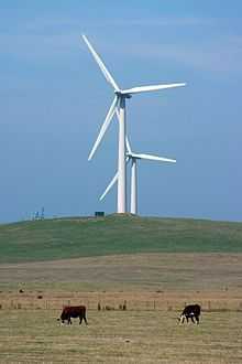
Power station Coordinates Max. Capacity (MW) Turbines Pumped storage
Bastyan 41°44′5″S 145°31′55″E / 41.73472°S 145.53194°E 79.9 1 no
Butlers Gorge 42°16′1″S 146°15′42″E / 42.26694°S 146.26167°E 12.2 1 no
Catagunya 42°27′8″S 146°35′52″E / 42.45222°S 146.59778°E 48 2 no
Cethana 41°28′47″S 146°8′1″E / 41.47972°S 146.13361°E 90 1 no
Cluny 42°30′23″S 146°40′52″E / 42.50639°S 146.68111°E 17 1 no
Devils Gate 41°21′1″S 146°15′48″E / 41.35028°S 146.26333°E 60 1 no
Fisher 41°40′24″S 146°16′06″E / 41.67333°S 146.26833°E 43.2 1 no
Gordon 42°43′50″S 145°58′35″E / 42.73056°S 145.97639°E 432 3 no
Huntsman Lake 41°41′30″S 146°37′12″E / 41.69167°S 146.62000°E 1.95 1 no
John Butters 42°9′17″S 145°32′3″E / 42.15472°S 145.53417°E 144 1 no
Lake Echo 42°15′13″S 146°37′13″E / 42.25361°S 146.62028°E 32.4 1 no
Lemonthyme 51 1 no
Liapootah 42°22′35″S 146°30′36″E / 42.37639°S 146.51000°E 87.3 3 no
Mackintosh 41°41′56″S 145°38′36″E / 41.69889°S 145.64333°E 79.9 1 no
Meadowbank 42°36′46″S 146°50′39″E / 42.61278°S 146.84417°E 40 1 no
Paloona 41°16′59″S 146°14′56″E / 41.28306°S 146.24889°E 28 1 no
Poatina 41°48′42″S 146°55′8″E / 41.81167°S 146.91889°E 300 6 no
Reece 41°43′25″S 145°8′10″E / 41.72361°S 145.13611°E 231.2 2 no
Repulse 42°30′25″S 146°38′45″E / 42.50694°S 146.64583°E 28 1 no
Rowallan 41°43′49″S 146°12′49″E / 41.73028°S 146.21361°E 10.5 1 no
Tarraleah 42°18′5″S 146°27′27″E / 42.30139°S 146.45750°E 90 6 no
Trevallyn 41°25′26″S 147°6′41″E / 41.42389°S 147.11139°E 90 4 no
Tribute 41°49′01″S 145°39′02″E / 41.81694°S 145.65056°E 84 1 no
Tungatinah 42°16′26″S 146°27′42″E / 42.27389°S 146.46167°E 125 5 no
Wayatinah 42°25′41″S 146°32′00″E / 42.42806°S 146.53333°E 38.25 3 no
Wilmot 41°28′48.5″S 146°7′22.6″E / 41.480139°S 146.122944°E 30.6 1 no

Wind farms

These wind farm power stations use the power of the wind to generate some or all of the electricity they produce.

Wind Farm Location Capacity (MW) Turbines Owner
Huxley Hill Wind Farm 39°56′42″S 143°53′38″E / 39.94500°S 143.89389°E 2.5 5 Hydro Tasmania
Musselroe Wind Farm 40°46′50″S 148°01′46″E / 40.78056°S 148.02944°E 168 56 Woolnorth Wind Farm Holdings
Woolnorth - Bluff Point Wind Farm 40°43′12″S 144°41′54″E / 40.72000°S 144.69833°E 65 37 Woolnorth Wind Farm Holdings
Woolnorth - Studland Bay Wind Farm 40°47′12″S 144°43′21″E / 40.78667°S 144.72250°E 75 25 Woolnorth Wind Farm Holdings

See also

External links