List of listed buildings in Small Isles, Highland
This is a list of listed buildings in the parish of Small Isles in the Highland council area of Scotland. This includes the islands of Canna, Eigg, Muck, Rùm and Sanday, as well as several smaller islands around these.
List
| Name | Location | Date listed | Grid ref.[1] Geo-coordinates |
Notes | HB number[2] | Image |
|---|---|---|---|---|---|---|
| Howlin | Isle of Eigg | 56°55′42″N 6°08′41″W / 56.928445°N 6.144645°W | Category B | 44969 | 
| |
| Clanranald Harbour | Isle of Eigg | 56°52′49″N 6°07′59″W / 56.880285°N 6.133079°W | Category C(S) | 14110 | 
| |
| Garden Gazebo, Kinloch Castle | Isle of Rùm | 57°00′50″N 6°16′47″W / 57.013836°N 6.279806°W | Category B | 14126 | 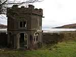
| |
| Roman Catholic Church and Presbytery, Cleadale | Isle of Eigg | 56°55′09″N 6°09′07″W / 56.919053°N 6.152054°W | Category C(S) | 44968 | 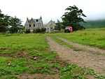
| |
| Kildonnan Barn | Isle of Eigg | 56°53′20″N 6°07′20″W / 56.888892°N 6.122202°W | Category C(S) | 14114 |
| |
| Bullough Mausoleum, Harris | Isle of Rùm | 56°58′30″N 6°23′07″W / 56.975071°N 6.385167°W | Category B | 14122 | Apr2006.jpg)
| |
| Canna House | Isle of Canna | 57°03′35″N 6°29′50″W / 57.059763°N 6.497201°W | Category B | 14128 |
| |
| Croft House, Cleadale | Isle of Eigg | 56°55′18″N 6°08′44″W / 56.921568°N 6.145657°W | Category C(S) | 44970 |
| |
| Kildonnan Farmhouse | Isle of Eigg | 56°53′19″N 6°07′21″W / 56.888542°N 6.122442°W | Category C(S) | 14113 |
| |
| Old Manse and Walled Garden (Former Church of Scotland Manse) | Isle of Eigg | 56°53′22″N 6°08′06″W / 56.889381°N 6.13512°W | Category B | 14116 |
| |
| Cottage 1/2 Mile West Of Gallanach Farm (Only Building) | Isle of Muck | 56°50′21″N 6°15′48″W / 56.839149°N 6.263215°W | Category B | 14120 |
| |
| Kiln by Pier | Isle of Rùm | 57°00′37″N 6°16′28″W / 57.010149°N 6.274552°W | Category C(S) | 14123 | 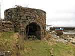
| |
| Former Mill, Kildonan | Isle of Eigg | 56°53′24″N 6°07′34″W / 56.889873°N 6.126237°W | Category B | 14117 | 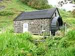
| |
| Bridge over the Slugan Burn, Kinloch Castle | Isle of Rùm | 57°00′46″N 6°16′51″W / 57.012729°N 6.280882°W | Category B | 14127 | .jpg)
| |
| Church of Scotland and Burial Ground | Isle of Canna | 57°03′31″N 6°29′37″W / 57.058708°N 6.493524°W | Category B | 14131 | 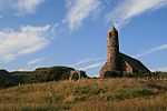
| |
| Eigg Lodge | Isle of Eigg | 56°52′50″N 6°08′23″W / 56.880534°N 6.139693°W | Category B | 14111 | 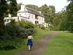
| |
| Roman Catholic Church | Isle of Sanday | 57°03′12″N 6°29′41″W / 57.053346°N 6.494807°W | Category B | 14132 | .jpg)
| |
| St. Donnan's Church And Burial Ground | Isle of Eigg | 56°53′29″N 6°07′31″W / 56.891384°N 6.125155°W | Category B | 14118 | 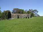
| |
| Bayview | Isle of Rùm | 57°00′33″N 6°16′14″W / 57.009229°N 6.270688°W | Category B | 14121 |
| |
| Old Pier | Isle of Rùm | 57°00′38″N 6°16′23″W / 57.010422°N 6.273133°W | Category C(S) | 14124 | 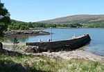
| |
| Kinloch Castle | Isle of Rùm | 57°00′49″N 6°16′55″W / 57.013644°N 6.281993°W | Category A | 14125 | 
| |
| Coroghon Barn | Isle of Canna | 57°03′37″N 6°29′26″W / 57.060142°N 6.490677°W | Category B | 14130 |
| |
| Church of Scotland and Burial Ground | Isle of Eigg | 56°53′32″N 6°08′16″W / 56.892248°N 6.137885°W | Category C(S) | 14133 | 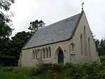
| |
| Shepherd's Bothy, Grulin | Isle of Eigg | 56°52′46″N 6°10′38″W / 56.879366°N 6.177145°W | Category B | 14112 | 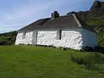
 Shepherd's Bothy, Grulin | |
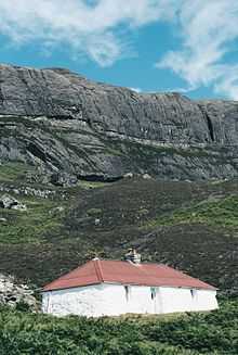
| Laig Farmhouse | Isle of Eigg | 56°54′40″N 6°09′46″W / 56.911089°N 6.162741°W | Category B | 14115 | .jpg)
| |
| Schoolhouse and School | Isle of Eigg | 56°53′58″N 6°08′23″W / 56.899578°N 6.139782°W | Category C(S) | 14119 | 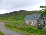
| |
| Change House and Steading/Barn | Isle of Canna | 57°03′28″N 6°30′01″W / 57.057868°N 6.500372°W | Category C(S) | 14129 | |
Key
The scheme for classifying buildings in Scotland is:
- Category A: "buildings of national or international importance, either architectural or historic, or fine little-altered examples of some particular period, style or building type."[3]
- Category B: "buildings of regional or more than local importance, or major examples of some particular period, style or building type which may have been altered."[3]
- Category C(S): "buildings of local importance, lesser examples of any period, style, or building type, as originally constructed or moderately altered; and simple traditional buildings which group well with others in categories A and B."[3]
There are approximately 47,400 listed buildings in Scotland. Of these, around 8 per cent (some 3,800) are Category A, and 51 per cent (24,000) are Category B, with the rest listed at Category C(s).[4]
See also
References
- All entries, addresses and coordinates are based on data from Historic Scotland. This data falls under the Open Government Licence
- ↑ Sometimes known as OSGB36, the grid reference (where provided) is based on the British national grid reference system used by the Ordnance Survey.
• "Guide to National Grid". Ordnance Survey. Retrieved 2007-12-12.
• "Get-a-map". Ordnance Survey. Retrieved 2007-12-17. - ↑ The "HB Number" is a unique number assigned to each listed building by Historic Scotland.
- ↑ 3.0 3.1 3.2 "What is Listing?". Historic Scotland. Retrieved 2010-07-06.
- ↑ Guide to the Protection of Scotland’s Listed Buildings. Historic Scotland. 2009. p. 17. ISBN 978-1-84917-013-0. Retrieved 2010-07-06.