List of lakes in Washington (state)
This is a list of natural lakes and reservoirs located fully or partially in the U.S. state of Washington. Natural lakes that have been altered with a dam, such as Lake Chelan, are included as lakes, not reservoirs.
| Key |
 denotes that body of water crosses state border denotes that body of water crosses state border |
 denotes that body of water crosses international border denotes that body of water crosses international border |
|
Reservoirs
| Name |
County(s) |
Coordinates |
Total storage (acre feet) |
Surface area
(acres) |
Max depth
(feet) |
Outflow |
| Franklin D. Roosevelt Lake |
Douglas, Ferry, Stevens, Lincoln, Grant, Okanogan [1] |
47°56′46.2″N 118°55′56″W / 47.946167°N 118.93222°W / 47.946167; -118.93222 (Franklin D. Roosevelt Lake)[2] |
9,386,000 [3] |
79,400 [4] |
400 |
Columbia River |
| Lake Umatilla |
Klickitat, Sherman (OR), Gilliam (OR), Morrow (OR), Benton, Umatilla (OR) |
45°43′32″N 120°12′44″W / 45.72556°N 120.21222°W / 45.72556; -120.21222 (Lake Umatilla)[5] |
|
48,738 |
|
Columbia River |
| Riffe Lake |
Lewis |
46°27′59″N 122°16′4″W / 46.46639°N 122.26778°W / 46.46639; -122.26778 (Riffe Lake)[6] |
1,686,300 [7] |
11,830 |
|
Cowlitz River |
| Ross Lake |
Whatcom, British Columbia |
48°52′6″N 121°1′47″W / 48.86833°N 121.02972°W / 48.86833; -121.02972 (Ross Lake)[8] |
1,435,000 |
11,700 |
|
Skagit River |
| Lake Wallula |
Benton, Walla Walla, Umatilla (OR) |
45°57′17″N 119°3′53″W / 45.95472°N 119.06472°W / 45.95472; -119.06472 (Lake Wallula)[9] |
1,350,000 [4] |
42,500 [4] |
|
Columbia River |
| Banks Lake |
Grant, Douglas |
47°48′21″N 119°11′31″W / 47.80583°N 119.19194°W / 47.80583; -119.19194 (Banks Lake)[10] |
1,275,000 [11] |
26,877 [12] |
177 [13] |
|
| Swift Reservoir |
Skamania |
46°3′20″N 122°6′51″W / 46.05556°N 122.11417°W / 46.05556; -122.11417 (Swift Reservoir)[14] |
755,600 [15] |
4,585 [16] |
|
Lewis River |
| Wanapum Lake |
Kittitas, Grant |
46°55′56″N 119°58′24″W / 46.93222°N 119.97333°W / 46.93222; -119.97333 (Wanapum Lake)[17] |
669,700 [18] |
14,590 [19] |
|
Columbia River |
| Rufus Woods Lake |
Douglas, Chelan |
47°59′47″N 119°37′14″W / 47.99639°N 119.62056°W / 47.99639; -119.62056 (Rufus Woods Lake)[20] |
590,199 [21] |
7,800 [22] |
|
Columbia River |
| Lake Herbert G. West |
Walla Walla, Columbia, Whitman, Franklin |
46°34′18″N 118°31′6″W / 46.57167°N 118.51833°W / 46.57167; -118.51833 (Lake Herbert G. West)[23] |
432,000 |
6,590 [24] |
|
Snake River |
| Merwin Lake |
Clark, Cowlitz |
45°58′35″N 122°31′35″W / 45.97639°N 122.52639°W / 45.97639; -122.52639 (Merwin Lake)[25] |
416,000 [26] |
3,836 [27] |
190 |
Lewis River |
| Yale Lake |
Clark, Cowlitz |
46°0′43″N 122°18′44″W / 46.01194°N 122.31222°W / 46.01194; -122.31222 (Yale Lake)[28] |
401,760 [29] |
3,612 |
|
Lewis River |
| Potholes Reservoir |
Grant |
46°59′59″N 119°17′6″W / 46.99972°N 119.28500°W / 46.99972; -119.28500 (Potholes Reservoir)[30] |
332,200 [31] |
27,800 [32] |
|
|
|
Natural lakes
| Name |
County(s) |
Coordinates |
Surface area (acres) |
Max depth |
Outflow |
| Lake Whatcom |
Whatcom |
48°44′45″N 122°20′45″W / 48.74583°N 122.34583°W / 48.74583; -122.34583 (Lake Whatcom)[33] |
5,003 |
328 |
Whatcom Creek |
| Rock Lake |
Whitman |
47°10′40″N 117°41′01″W / 47.17778°N 117.68361°W / 47.17778; -117.68361 |
2,190 |
375 |
Rock Creek |
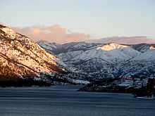
| Lake Chelan |
Chelan |
47°51′5″N 120°4′56″W / 47.85139°N 120.08222°W / 47.85139; -120.08222 (Lake Chelan)[34] |
32,000 |
1,486 |
Chelan River |
| Lake Washington |
King |
47°40′10.5″N 122°13′53″W / 47.669583°N 122.23139°W / 47.669583; -122.23139 (Lake Washington)[35] |
22,138 |
214 |
Lake Washington Ship Canal |
| Lake Ozette |
Clallam,[36] |
48°5′41″N 124°38′14″W / 48.09472°N 124.63722°W / 48.09472; -124.63722 (Lake Ozette)[37] |
7,787 |
331 |
Ozette River |
| Moses Lake |
Grant |
47°8′12″N 119°20′30″W / 47.13667°N 119.34167°W / 47.13667; -119.34167 (Moses Lake)[38] |
6,815 |
38 |
Potholes Reservoir |
| Osoyoos Lake |
Okanogan, British Columbia |
49°0′0″N 119°26′40″W / 49.00000°N 119.44444°W / 49.00000; -119.44444 (Osoyoos Lake)[39] |
5,723 |
208 |
Okanogan River |
| Paradise Lake |
King |
47°46′25″N 122°04′06″W / 47.77361°N 122.06833°W / 47.77361; -122.06833 (Paradise Lake)[40] |
18 |
28 |
|
|
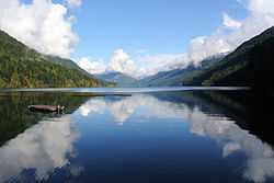
| Lake Crescent |
Clallam |
48°3′32″N 123°48′53″W / 48.05889°N 123.81472°W / 48.05889; -123.81472 (Lake Crescent)[41] |
5,187 |
624 |
Lyre River |
|
See also
References
External links