List of islands of Wyoming
|
Location of Wyoming within the United States | |
| Geography | |
|---|---|
| Location | Wyoming |
| Total islands | 32 |
| Country | |
| State |
|

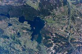
Yellowstone Lake contains several of Wyoming's islands, of which Frank Island is the largest.
The following is a list of islands of Wyoming. Occupying 97,814 square miles (253,348 km²), the state of Wyoming is the tenth largest state in the country. It is the sixth largest state to not have an ocean coastline. Despite being landlocked, Wyoming does contain islands; the state contains 713.16 square miles (1,847 km²) of water, which is 0.72% of the state's total area.
Wyoming has 32 named islands, in which the majority of those are located in Jackson Lake and Yellowstone Lake within Yellowstone National Park in the northwest portion of the state. Green River in the southwest also contains a number of islands.
References
- ↑ "Arizona Island". Geographic Names Information System. United States Geological Survey.
- ↑ "Badger Island". Geographic Names Information System. United States Geological Survey.
- ↑ "Boulder Island". Geographic Names Information System. United States Geological Survey.
- ↑ "Bush Island". Geographic Names Information System. United States Geological Survey.
- ↑ "Carrington Island". Geographic Names Information System. United States Geological Survey.
- ↑ "Cow Island". Geographic Names Information System. United States Geological Survey.
- ↑ "Dollar Island". Geographic Names Information System. United States Geological Survey.
- ↑ "Donoho Island". Geographic Names Information System. United States Geological Survey.
- ↑ "Dot Island". Geographic Names Information System. United States Geological Survey.
- ↑ "Elk Island". Geographic Names Information System. United States Geological Survey.
- ↑ "Ferry Island". Geographic Names Information System. United States Geological Survey.
- ↑ "Frank Island". Geographic Names Information System. United States Geological Survey.
- ↑ "Freezeout Island". Geographic Names Information System. United States Geological Survey.
- ↑ "Grassy Island". Geographic Names Information System. United States Geological Survey.
- ↑ "Indian Island". Geographic Names Information System. United States Geological Survey.
- ↑ "Johnson Island". Geographic Names Information System. United States Geological Survey.
- ↑ "Long Island". Geographic Names Information System. United States Geological Survey.
- ↑ "Marie Island". Geographic Names Information System. United States Geological Survey.
- ↑ "Molly Island". Geographic Names Information System. United States Geological Survey.
- ↑ "Molly Islands". Geographic Names Information System. United States Geological Survey.
- ↑ "Moose Island". Geographic Names Information System. United States Geological Survey.
- ↑ "Mullison Island". Geographic Names Information System. United States Geological Survey.
- ↑ "Mystic Isle". Geographic Names Information System. United States Geological Survey.
- ↑ "Oxbow Bends". Geographic Names Information System. United States Geological Survey.
- ↑ "Peale Island". Geographic Names Information System. United States Geological Survey.
- ↑ "Pelican Roost". Geographic Names Information System. United States Geological Survey.
- ↑ "Sheffield Island". Geographic Names Information System. United States Geological Survey.
- ↑ "Stevenson Island". Geographic Names Information System. United States Geological Survey.
- ↑ "Tarters Island". Geographic Names Information System. United States Geological Survey.
- ↑ "Telephone Island". Geographic Names Information System. United States Geological Survey.
- ↑ "Treasure Island". Geographic Names Information System. United States Geological Survey.
- ↑ "Willow Island". Geographic Names Information System. United States Geological Survey.
External links
| ||||||||||||||||||||||||||
| ||||||||||||||||||