List of islands of California
- This list is incomplete; you can help by expanding it.
This list of islands of California is organized into sections, generally arranged from north to south. The islands within each section are listed in alphabetical order.
The Geographic Names Information System (GNIS) lists 527 named islands in the state.[1]
Humboldt Bay
All three islands in Humboldt Bay are located in the narrow midsection of the bay. This portion of the bay is located within the City of Eureka, California entirely within Humboldt County.
| Island | Image | Coordinates | Description |
|---|---|---|---|
| Daby Island | The smallest of the three islands, this island has a maximum elevation of 3 feet and is located just northeast of Woodley Island. | ||
| Indian Island | 40°48′46″N 124°10′06″W / 40.8129°N 124.1684°W | The largest island, 1.3 miles (2.1 km) long, was originally the center of culture and population of the indigenous Wiyot people. Now protected, no public access is allowed, except for the Wiyot and grandfathered residents. | |
| Woodley Island | The second largest of three islands. Woodley Island Marina (Eureka's largest marina), the Eureka regional office of the National Weather Service, and offices of the Humboldt Bay Harbor Recreation & Conservation District are located on the island. | ||
San Francisco Bay Area
Other islands of the San Francisco Bay Area:
| Island | Image | Coordinates | Counties | Description |
|---|---|---|---|---|
| Alameda Island | 37°45′55″N 122°14′30″W / 37.76528°N 122.24167°W | Alameda, San Francisco (small, uninhabited sliver) | This 6-mile (9.7 km) long island in San Francisco Bay is the main part of the City of Alameda. | |
| Alcatraz Island |  |
37°49′36″N 122°25′24″W / 37.8266°N 122.4233°W | San Francisco | This 22-acre (8.9 ha) island in San Francisco Bay once served as a lighthouse, a military fortification, a military prison, and as a federal prison until 1963. It is now part of the Golden Gate National Recreation Area. |
| Angel Island | 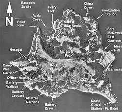 |
37°51′46″N 122°25′51″W / 37.862778°N 122.430833°W | Marin | With an area of 1.2 square miles (3.1 km2), this island in San Francisco Bay processed approximately 1 million immigrants to the U.S. during 1910 to 1940. It is currently a state park. |
| Año Nuevo Island | 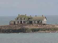 |
37°06′31″N 122°20′16″W / 37.1086°N 122.3378°W[2] | San Mateo | Small Pacific island, about 0.2 miles (0.32 km) long, near Año Nuevo (New Year's) Point, south of the Golden Gate. It is protected by the Año Nuevo State Reserve as an important habitat for seabirds and other coastal wildlife. |
| Bair Island | 37°31′48″N 122°13′20″W / 37.5299°N 122.2222°W | San Mateo | This 2,600-acre (1,100 ha) island in San Francisco Bay near Redwood City is part of the Don Edwards San Francisco Bay National Wildlife Refuge. | |
| Bay Farm Island |  |
37°44′17″N 122°15′07″W / 37.738°N 122.252°W | Alameda | This former island in San Francisco Bay has been connected to the mainland. It is part of the City of Alameda. |
| Belvedere Island | 37°52′18″N 122°28′07″W / 37.8716°N 122.4685°W | Marin | This former island in Richardson Bay has been connected to the mainland. It is part of the City of Belvedere. | |
| Bird Island | 37°49′27″N 122°32′12″W / 37.8241°N 122.5366°W[3] | Marin | Small Pacific island between Point Bonita and Rodeo Cove. | |
| Bird Rock | |
38°13′48″N 122°59′40″W / 38.2299°N 122.9944°W[4] | Marin | Small Pacific island west of Tomales Point, primarily a seabird colony. It covers 2 acres (0.81 ha). |
| Brooks Island | 37°53′47″N 122°21′19″W / 37.89639°N 122.35528°W | Contra Costa | A 65-acre (26 ha) island in San Francisco Bay south of Richmond, protected as part of the Brooks Island Regional Shoreline. | |
| The Brothers | 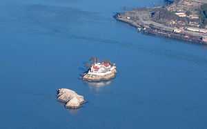 |
37°57′48″N 122°25′59″W / 37.96333°N 122.43306°W | Contra Costa | Two small islands, East Brother and West Brother, located west of Point San Pablo. Each is about 300 feet (91 m) long. East Brother has a lighthouse and a bed and breakfast. |
| Castro Rocks | 37°55′56″N 122°25′07″W / 37.93222°N 122.41861°W | Contra Costa | Beneath the Richmond – San Rafael Bridge. | |
| Coast Guard Island | 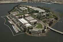 |
37°46′56″N 122°15′00″W / 37.78222°N 122.25000°W | Alameda | Located in the Oakland Estuary, this 67-acre (27 ha) artificial island is part of the City of Alameda. It is home to various United States Coast Guard facilities. |
| Corinthian Island | 37°52′22″N 122°27′32″W / 37.87278°N 122.45889°W | Marin | This former island was joined to the mainland in the 1980s. It is split between the city of Belvedere and the town of Tiburon. | |
| East Marin Island | 37°57′52″N 122°28′06″W / 37.96444°N 122.46833°W | Marin | Near San Rafael, California. | |
| Gull Rock | 37°52′34″N 122°36′59″W / 37.8760°N 122.6164°W | Marin | A Pacific island near Mount Tamalpais, about 200 feet (61 m) long. | |
| Hog Island (Petaluma River) | 38°09′33″N 122°32′18″W / 38.1591°N 122.5383°W | Sonoma | Island in the Petaluma River wetlands. | |
| Hog Island (Tomales Bay) | |
38°11′50″N 122°56′09″W / 38.1971°N 122.9358°W | Marin | A 2-acre (0.81 ha) island in Tomales Bay. |
| Kent Island | 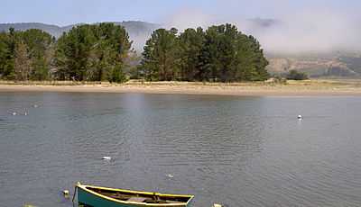 |
37°54′44″N 122°40′43″W / 37.9121°N 122.6786°W | Marin | An island in Bolinas Lagoon, near the town of Bolinas. About 0.5 miles (0.80 km) long. |
| Mare Island |  |
38°05′44″N 122°16′21″W / 38.0955°N 122.2725°W | Solano | An island in San Pablo Bay near Vallejo. About 3.5 miles (5.6 km) long, site of a major shipyard. |
| Mussel Rock |  |
37°40′01″N 122°29′50″W / 37.6669°N 122.4972°W | San Mateo | A stack in the Pacific Ocean near Daly City. About 200 feet (61 m) long. |
| Rat Rock | |
38°00′16″N 122°27′43″W / 38.00444°N 122.46194°W | Marin | An 18-foot (5.5 m) tall rock north of China Camp. |
| Red Rock Island | 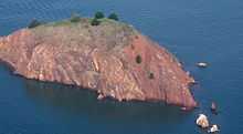 |
37°55′45″N 122°25′51″W / 37.92917°N 122.43083°W | Contra Costa, Marin and San Francisco | This uninhabited 5.8-acre (2.3 ha) island is located in San Francisco Bay just south of the Richmond – San Rafael Bridge, near the meeting point of three counties. It is privately owned. |
| San Pedro Rock | 37°35′43″N 122°31′27″W / 37.5952°N 122.5241°W | San Mateo | A Pacific island near the city of Pacifica. About 800 feet (240 m) long. | |
| Seal Rocks (San Francisco, California) | 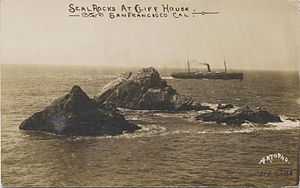 |
37°46′43″N 122°30′58″W / 37.77861°N 122.51611°W | San Francisco | A series of large rocks in the Pacific Ocean that host a sea lion colony. |
| Seal Rock (San Mateo County, California) | 37°23′30″N 122°25′29″W / 37.3916°N 122.4247°W | San Mateo | A Pacific island south of Half Moon Bay, about 500 feet (150 m) long. | |
| Sears Rock | 37°49′43″N 122°32′57″W / 37.8285°N 122.5491°W | Marin | A rock in the Centissima Reef. | |
| The Sisters | 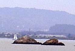 |
37°59′18″N 122°26′28″W / 37.9883°N 122.4411°W | Marin | A pair of small islands in San Pablo Bay, 2,000 feet (610 m) south of Point Saint Pedro. |
| Treasure Island | 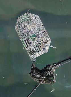 |
37°49′29″N 122°22′16″W / 37.82472°N 122.37111°W | San Francisco | This 403-acre (163 ha) artificial island in San Francisco Bay is tied to Yerba Buena Island. It was dredged out of the bay to house the Golden Gate International Exposition of 1939-40. |
| West Marin Island | 37°57′57″N 122°28′22″W / 37.96583°N 122.47278°W | Marin | Near San Rafael, California. | |
| Yerba Buena Island | 37°48′36″N 122°21′58″W / 37.81000°N 122.36611°W | San Francisco | This island in San Francisco Bay is home to a Coast Guard station. The San Francisco – Oakland Bay Bridge passes through it by means of a tunnel. |
Farallon Islands
The Farallon Islands are a group of rugged small islands over 20 miles (32 km) offshore from the mainland of the City and County of San Francisco, which they are also formally within. They consist of over twenty small islets divided into north, south and middle sections, as well as a major bank, Fanny Shoal. The surrounding waters were once used as a disposal site for radioactive waste.[5]
| Island | Image | Coordinates | Description |
|---|---|---|---|
| Aulone Island and Great Arch Rock | 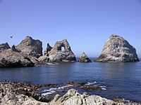 |
37°42′08″N 123°00′15″W / 37.7023°N 123.0042°W | North of Southeast Farallon Island, measuring 200 feet (61 m) wide and 400 feet (120 m) long. |
| Drunk Uncle Islets | Group of small islets north of Maintop Island. | ||
| Farallón Viscaíno | |||
| Middle Farallon Island | 37°43′38″N 123°01′56″W / 37.7272°N 123.0322°W | Medium-sized islet 1.8 miles (2.9 km) northwest of Southeast Farallon Island. It is 210 feet (64 m) long and has an area of 0.8 acres (0.32 ha). | |
| North Farallon Island | 37°45′44″N 123°05′53″W / 37.7622°N 123.0981°W | Medium-sized islet 500 feet (150 m) long and 100 feet (30 m) high, covering 2 acres (0.81 ha). | |
| Peñasco Quebrado | |||
| Piedra Guadalupe | |||
| Island of St. James | 37°46′00″N 123°06′05″W / 37.7666°N 123.1014°W | Medium-sized islet 3 acres (1.2 ha) in size, measuring 410 feet (120 m) long and 154 feet (47 m) high. | |
| Sea Lion Rock | 37°42′10″N 123°00′19″W / 37.7029°N 123.0054°W | Small islet northwest of Aulon Island, about 130 feet (40 m) long. | |
| Seal Rock | 37°41′38″N 123°00′12″W / 37.6938°N 123.0033°W | Small islet south of Southeast Farallon Island, with a maximum height of 82 feet (25 m). | |
| Maintop Island | 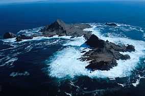 |
37°41′57″N 123°00′40″W / 37.6991°N 123.0111°W | West of Southeast Farallon Island, and has a maximum height of 223 feet (68 m). |
| Southeast Farallon Island |  |
37°41′50″N 123°00′11″W / 37.6972°N 123.0031°W | Is the largest of the Farallons, covering 0.19 square miles (0.49 km2). It is the only inhabited Farallon Island, and is also the site of Farallon Island Light. |
| Sugarloaf Island | 37°42′13″N 123°00′12″W / 37.7035°N 123.0032°W | Directly to the northeast of Aulone and Great Arch Rock, about 80 feet (24 m) high. |
Suisun Bay
Suisun Bay is an arm of the San Francisco Bay estuary which connects the Sacramento and San Joaquin rivers to the Carquinez Strait.
Sacramento-San Joaquin River Delta
The Sacramento-San Joaquin River Delta is an inverted delta at the juncture of the Sacramento and San Joaquin rivers.
| Island | Image | Coordinates | County | Description |
|---|---|---|---|---|
| Andrus Island | 38°09′28″N 121°35′54″W / 38.1577°N 121.5983°W | Sacramento | 3,000-hectare (7,400-acre) island, bounded by Sacramento River, Georgiana Slough, Mokelumne River, San Joaquin River, Jackson Slough, and Seven Mile Slough. | |
| Bacon Island | 37°58′36″N 121°33′08″W / 37.9766°N 121.5522°W | San Joaquin | 2,200-hectare (5,400-acre) island, bounded by Connection Slough, Old River, Woodward Island, and Middle River | |
| Bethel Island | 38°01′53″N 121°38′27″W / 38.0313°N 121.6408°W | Contra Costa | 1,450-hectare (3,600-acre) island, bounded by Taylor Slough, Piper Slough, Sand Mound Slough, and Dutch Slough | |
| Bouldin Island | 38°06′15″N 121°32′05″W / 38.1041°N 121.5347°W | San Joaquin | 2,400-hectare (5,900-acre) island bounded by South Mokelumne River, Little Potato Slough, Potato Slough, and Mokelumne River. | |
| Bradford Island | 38°04′38″N 121°39′48″W / 38.0771°N 121.6633°W | Contra Costa | 885-hectare (2,190-acre) island in the lower delta bounded by the San Joaquin River, False River and the Bradford Island canal/slough. Accessible only by Ferry via Jersey Island, just south of it. | |
| Browns Island | 37°57′37″N 121°21′21″W / 37.9602°N 121.3558°W | Contra Costa | 275-hectare (680-acre) island, bounded by Middle Slough, New York Slough, and Suisun Bay | |
| Jersey Island | 38°02′11″N 121°41′09″W / 38.0363°N 121.6858°W | Contra Costa | 1,425-hectare (3,520-acre) island, bounded by False River, Piper Slough, Taylor Slough, Dutch Slough and San Joaquin River. | |
| Jones Tract | upper: 37°55′12″N 121°28′35″W / 37.9199°N 121.4763°W lower:37°57′16″N 121°29′38″W / 37.9544°N 121.4938°W (lower) |
San Joaquin | 4,900-hectare (12,000-acre) island (tracts, Upper- and Lower-), bounded by Empire Cut, Whiskey Slough, Trapper Slough, and Middle River, 10 km east of Stockton | |
| King Island | 38°03′56″N 121°26′12″W / 38.0655°N 121.4366°W | San Joaquin | 1,300-hectare (3,200-acre) island bounded by White Slough, Bishop Cut, Disappointment Slough, and Honker Cut | |
| Kings Island | 37°51′29″N 121°34′08″W / 37.8580°N 121.5688°W | Contra Costa | 3.5-hectare (8.6-acre) island in Old River | |
| McDonald Island | 38°00′05″N 121°29′24″W / 38.0013°N 121.4900°W | San Joaquin | 2,400-hectare (5,900-acre) island, bounded by San Joaquin River, Middle River, Latham Slough, and Empire Cut. | |
| Merritt Island | 38°21′19″N 121°33′01″W / 38.3554°N 121.5503°W | Yolo | A 5,000 acres (2,000 ha) island formed by the Sacramento River to the southeast and Elk Slough to the west, located directly across the Sacramento from Hood. | |
| Ryer Island | 38°14′26″N 121°38′03″W / 38.2405°N 121.6341°W | Solano | 4,750-hectare (11,700-acre), bounded by Miner Slough and Steamboat Slough. | |
| Sherman Island | 38°03′34″N 121°44′00″W / 38.0594°N 121.7333°W | Sacramento | 5,500-hectare (14,000-acre) island bounded by the Sacramento River, Three Mile Slough, and the San Joaquin River. | |
| Staten Island | 38°09′52″N 121°30′59″W / 38.1644°N 121.5163°W | San Joaquin | 3,700-hectare (9,100-acre) island bounded and flanked by the North Mokelumne River and South Mokelumne River. | |
| Sutter Island | 38°17′29″N 121°35′35″W / 38.2913°N 121.5930°W | Sacramento | Formed by Sacramento River to the northeast, Steamboat Slough to the southeast, and Sutter Slough to the west. Located across the Sacramento River from Paintersville. | |
| Twitchell Island | 38°06′35″N 121°38′55″W / 38.1096°N 121.6486°W | Sacramento | 3,000-hectare (7,400-acre), bounded by Seven Mile Slough, San Joaquin River, and Three Mile Slough | |
| Venice Island | 38°04′30″N 121°32′04″W / 38.0749°N 121.5344°W | San Joaquin | 1,250-hectare (3,100-acre) island bounded by Potato Slough, Little Connection Slough, Stockton Deepwater Channel Venice Cut, and San Joaquin River. | |
| Victoria Island | 37°53′24″N 121°32′05″W / 37.8899°N 121.5347°W | San Joaquin | 2,900-hectare (7,200-acre) island bounded by North Victoria Canal, Middle River, Victoria Canal, and Old River. | |
| West Island | 38°01′24″N 121°46′43″W / 38.0233°N 121.7786°W | Sacramento | ||
| Winter Island | 38°02′32″N 121°50′55″W / 38.0421°N 121.8486°W | Contra Costa | ||
| Woodward Island | 37°55′42″N 121°32′46″W / 37.9283°N 121.5461°W | San Joaquin | 725-hectare (1,790-acre) island bounded by Bacon Island, Old River, Middle River, and Woodward Canal |
Channel Islands
The Channel Islands are a group of eight main islands and several minor islands in the Pacific Ocean off the coast of Santa Barbara, Los Angeles, and Ventura counties in Southern California. The four northern islands are protected in Channel Islands National Park, while two are used by the U.S. Navy. These Islands are part of the Greater Los Angeles Area.
| Island | Image | Coordinates | Description |
|---|---|---|---|
| Anacapa Island | 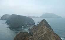 |
34°00′16″N 119°23′59″W / 34.0045°N 119.3996°W[7] | Located 14 miles (23 km) off the coast of Ventura, California. It contains 728 acres (295 ha) of land spread across three mountainous islets. The island has only three permanent residents. Part of the Greater Los Angeles Area. |
| Begg Rock | 33°21′45″N 119°41′52″W / 33.36250°N 119.69778°W[8] | A 15-foot (4.6 m) high rock, located 8 miles (13 km) from San Nicolas Island. | |
| Prince Island | 34°03′29″N 120°20′01″W / 34.05806°N 120.33361°W | Located near San Miguel Island and measures about 35 acres (14 ha). | |
| San Clemente Island | 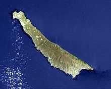 |
32°54′00″N 118°30′03″W / 32.9000°N 118.5009°W[9] | Southernmost Channel Island, containing 56.81 square miles (147.1 km2) of land. It is 24 miles (39 km) long, and uninhabited. An active U.S. Navy base is located on the island. In Los Angeles County. |
| San Miguel Island | 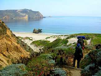 |
34°02′23″N 120°22′31″W / 34.0397°N 120.3754°W[10] | Westernmost Channel Island, measuring 8 miles (13 km) long, 3.7 miles (6.0 km) wide, and containing 9,325 acres (3,774 ha) of land. The island is uninhabited, and is rarely visited. Part of the Greater Los Angeles Area. |
| San Nicolas Island | 33°14′58″N 119°30′01″W / 33.2495°N 119.5004°W[11] | Is said to be the most remote island of the Channel Islands, and is used by the U.S. Navy as a weapons testing and training facility. It has no civilian inhabitants, but is inhabited by military personnel. It covers 14,562 acres (5,893 ha). Part of the Greater Los Angeles Area. | |
| Santa Barbara Island |  |
33°28′32″N 119°02′10″W / 33.4756°N 119.0362°W[12] | Smallest Channel Island at 640 acres (260 ha) in area; it is located roughly between San Nicolas and Santa Catalina Islands. Part of the Greater Los Angeles Area. |
| Santa Catalina Island | 33°23′00″N 118°25′03″W / 33.3834°N 118.4176°W[13] | The most inhabited of the Channel Islands, with a population of 3,696 as of 2000. It is about 22 miles (35 km) long with a maximum width of 8 miles (13 km). It covers 74.98 square miles (194.2 km2). In Los Angeles County. | |
| Santa Cruz Island | 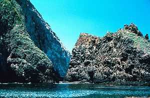 |
34°02′25″N 119°50′37″W / 34.0403°N 119.8437°W[14] | Santa Cruz Island measures 22 miles (35 km) long with an average width of 4 miles (6.4 km), covering 96.5 square miles (250 km2). It is the largest Channel Island. The island is now on public land, but was previously the largest privately owned island of the continental United States. Part of the Greater Los Angeles Area. |
| Santa Rosa Island |  |
33°57′00″N 120°06′04″W / 33.9500°N 120.1010°W[15] | Santa Rosa Island occupies 83.1 square miles (215 km2), and is the second largest Channel Island. The island has a permanent population of 2 persons, and is about 26 miles (42 km) off the coast of Santa Barbara, California. Part of the Greater Los Angeles area. |
| Shag Rock | 33°29′13″N 119°02′10″W / 33.4870°N 119.0362°W[16] | Small islet located off the north shore of Santa Barbara Island, and is only about 1 acre (0.40 ha). | |
| Sutil Island | 33°27′50″N 119°02′54″W / 33.4639°N 119.0482°W[17] | Located off the southwest shore of Santa Barbara Island, and is about 12 acres (4.9 ha). It is named for a Spanish ship exploring the West Coast in an expedition led by Sebastián Vizcaíno. |
Greater Los Angeles Area
The Greater Los Angeles Area is an urban area on the Pacific coast of southern California.
| Island | Image | Coordinates | Description |
|---|---|---|---|
| Island Chaffee | 33°44′23″N 118°08′20″W / 33.7397°N 118.1390°W | An artificial island/oil platform named after astronaut Roger B. Chaffee who died in the Apollo 1 accident. Located in San Pedro Bay. | |
| Deadman's Island | 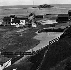 |
33°43′25″N 118°15′57″W / 33.7236°N 118.2659°W | A former island in Los Angeles Harbor, removed in 1928 and sometimes referred to as Isla Del Umberto or Reservation Point. |
| Freeman Island | 33°44′29″N 118°09′45″W / 33.7414°N 118.1624°W | An artificial island/oil platform named after astronaut Theodore Freeman who died in a crash. Located in San Pedro Bay. | |
| Island Grissom | 33°45′33″N 118°10′53″W / 33.7592°N 118.1815°W | An artificial island/oil platform named after astronaut Gus Grissom who died in the Apollo 1 accident. Located in San Pedro Bay. | |
| Naples Islands | 33°27′05″N 118°43′12″W / 33.4515°N 118.7201°W | A neighborhood in Long Beach that consists of three different islands divided by canals which empty out into Alamitos Bay. | |
| Terminal Island | 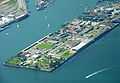 |
33°45′25″N 118°14′53″W / 33.7570°N 118.2481°W | An artificial island shared between the cities of Los Angeles and Long Beach. It is 3.5 miles (5.6 km) long and covers an area of 4.46 square miles (11.6 km2). |
| Island White | 33°45′10″N 118°09′33″W / 33.7528°N 118.1592°W | An artificial island/oil platform named after astronaut Edward Higgins White who died in the Apollo 1 accident; Located in San Pedro Bay.[18][19] | |
Newport Bay
The bay associated with Newport Harbor and the city of Newport Beach, California.
| Island | Image | Coordinates | Description |
|---|---|---|---|
| Balboa Island | 33°36′23″N 117°53′40″W / 33.60639°N 117.89444°W | A 50-hectare (120-acre), densely populated harbor island with 1,500 expensive homes. Partially created as a result of the Santa Ana River flooding in 1824, then artificially expanded to its present size. | |
| Bay Island | 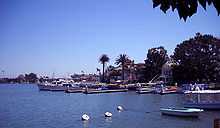 |
33°36′25″N 117°54′18″W / 33.607°N 117.905°W | West of Balboa Island. |
| Harbor Island | 33°36′01″N 117°54′10″W / 33.6003°N 117.9028°W | ||
| Lido Isle |  |
33°36′14″N 117°55′02″W / 33.6039°N 117.9173°W | Northwest of Balboa Island. |
| Linda Isle | 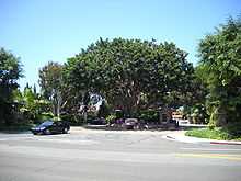 |
33°36′50″N 117°54′13″W / 33.6139°N 117.9037°W | North of Harbor Island. |
Lake islands
| Island | Image | Coordinates | Lake | Description |
|---|---|---|---|---|
| Beaver Island | 40°45′24″N 122°19′57″W / 40.7566°N 122.3325°W | Shasta Lake | An island in the Pit River Arm of the lake, located just west of the Pit River Bridge and Bridge Bay Resort/marina. | |
| Fannette Island | 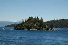 |
38°57′15″N 120°06′02″W / 38.9541°N 120.1005°W | Lake Tahoe | The only major island in Lake Tahoe, located within Emerald Bay.[20] |
| Main Island |  |
34°23′41″N 119°20′34″W / 34.3947°N 119.3429°W | Lake Casitas | A 1.5 miles (2.4 km) long, 850-foot (260 m) high island rising 512 feet (156 m) above the lake surface. |
| Mullet Island | Salton Sea | A small volcanic island near the southern end of the Salton Sea near the mouth of the Alamo River | ||
| Negit Island | 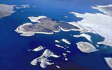 |
38°01′22″N 119°02′59″W / 38.0227°N 119.0496°W[21] | Mono Lake | A young volcanic cone, connected to the mainland during low water. It is an important stop for nesting birds, and as a result is closed to visitation during April. |
| Paoha Island | |
38°00′02″N 119°01′57″W / 38.0005°N 119.0324°W[22] | Mono Lake | 2.5 miles (4.0 km) long and 2 miles (3.2 km) wide, and is the largest Mono Lake island. |
| Rattlesnake Island | 39°00′36″N 122°40′44″W / 39.0099°N 122.6789°W | Clear Lake | A 53-acre (21 ha) island desired by the Elem Indian Colony. | |
| Red Island | Salton Sea | A volcanic island near the southern end of the sea, on the San Andreas Fault. | ||
| Ridgeville Islands | 40°50′43″N 122°47′15″W / 40.8453°N 122.7875°W | Trinity Lake | A group of forested islets in the Stewart Fork arm about 4 mi (6.4 km) northwest of Trinity Dam. | |
| Ski Island | 40°45′33″N 122°15′31″W / 40.7592°N 122.2587°W | Shasta Lake | An island in the Pit River arm of the lake, located shortly north of Bear Mountain. | |
| Slaughterhouse Island | 40°45′54″N 122°23′01″W / 40.7651°N 122.3835°W | Shasta Lake | An island in the Sacramento River Arm of the lake, located about 3 mi (4.8 km) northeast of Shasta Dam. |
Miscellaneous
| Island | Image | Coordinates | Description |
|---|---|---|---|
| Rincon Island | 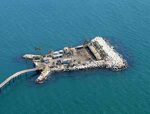 |
34°20′51″N 119°26′43″W / 34.3475°N 119.4454°W | A 1 acre (0.40 ha) artificial island off the coast of Ventura County, leased for oil and gas production. |
See also
- Coastal islands of Alta and Baja California
- Geography of California
- List of islands of the United States
- Outline of California
References
- ↑ "GNIS Feature Search". Retrieved 2009-07-29.
- ↑ "Año Nuevo Island". Geographic Names Information System. United States Geological Survey. Retrieved 2009-05-26.
- ↑ "Bird Island". Geographic Names Information System. United States Geological Survey. Retrieved 2009-05-26.
- ↑ "Bird Rock". Geographic Names Information System. United States Geological Survey. Retrieved 2009-05-26.
- ↑ "Atlas of Gulf of the Farallones Region, Central California". United States Geological Survey. Retrieved 2009-05-26.
- ↑ David L. Durham, "California's Geographic Names: A Gazetteer of Historic and Modern Names of This State," p. 693 (Quill Driver Books 1998) ISBN 1-884995-14-4.
- ↑ "Anacapa Island". Geographic Names Information System. United States Geological Survey. Retrieved 2009-05-26.
- ↑ "Begg Rock". Geographic Names Information System. United States Geological Survey.
- ↑ "San Clemente Island". Geographic Names Information System. United States Geological Survey. Retrieved 2009-05-26.
- ↑ "San Miguel Island". Geographic Names Information System. United States Geological Survey. Retrieved 2009-05-26.
- ↑ "San Nicolas Island". Geographic Names Information System. United States Geological Survey. Retrieved 2009-05-26.
- ↑ "Santa Barbara Island". Geographic Names Information System. United States Geological Survey. Retrieved 2009-05-26.
- ↑ "Santa Catalina Island". Geographic Names Information System. United States Geological Survey. Retrieved 2009-05-26.
- ↑ "Santa Cruz Island". Geographic Names Information System. United States Geological Survey. Retrieved 2009-05-26.
- ↑ "Santa Rosa Island". Geographic Names Information System. United States Geological Survey. Retrieved 2009-05-26.
- ↑ "Shag Rock". Geographic Names Information System. United States Geological Survey. Retrieved 2009-05-26.
- ↑ "Sutil Island". Geographic Names Information System. United States Geological Survey. Retrieved 2009-05-26.
- ↑ Fallen Astronaut
- ↑ pdf of City of Long Beach Economic Zones
- ↑ "Fannette Island". Geographic Names Information System. United States Geological Survey. Retrieved 2009-05-26.
- ↑ "Negit Island". Geographic Names Information System. United States Geological Survey. Retrieved 2009-05-26.
- ↑ "Paoha Island". Geographic Names Information System. United States Geological Survey. Retrieved 2009-05-26.
Further reading
- Martin, James A.; Lee, Michael T. (2006). The Islands of San Francisco Bay. San Rafael, CA: Down Window Press. ISBN 0-9787241-0-0.
External links
| Wikimedia Commons has media related to Islands of California. |
| ||||||||||||||||||