List of highways in Western Australia
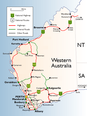

Highways in Western Australia include both roads that are named as a highway, and roads that have been declared as a highway under the Main Roads Act 1930. The standard of highways range from two-lane roads, common in rural areas, to controlled access, grade separated freeways in Perth.
In legislation, a highway is a type of road controlled and maintained by the state road authority, Main Roads Western Australia. Any road or section of road may be proclaimed a highway by the Governor of Western Australia, on the recommendation of the Commissioner of Main Roads, under Section 13 of the Main Roads Act 1930.[1] Section 14 of the act allows for the creation of new highways.[1] Main Roads assigns each highway a name and number, which may vary from the common road names used on road signs and by the general public.[2] The highway number does not correspond to a road route that may be allocated to the highway, and some highways are not part of a numbered route.[2]
Proclaimed highways
| No | Road | From | To | Notes |
|---|---|---|---|---|
| H1 | Albany Highway | Perth | Albany | Includes Shepperton Road and The Causeway in Perth |
| H2 | Perth–Bunbury Highway | Melville | Mandurah | Local road names are Stock Road, Rockingham Road, Ennis Avenue, Mandurah Road, Old Coast Road, Australind Bypass, Robertson Drive |
| H3 | Eyre Highway | Norseman | WA/SA border | |
| H4 | Brand Highway | Muchea | Geraldton | |
| H5 | Great Eastern Highway | Burswood | Kalgoorlie | Includes Johnson Street, James Street and East Street in Guildford, and Hannan Street in Kalgoorlie |
| H6 | Great Northern Highway | Midland | Wyndham | |
| H7 | North West Coastal Highway | Geraldton | Port Hedland | |
| H8 | South Coast Highway | Albany | Esperance | Includes Chester Pass Road in Albany and Morgans Street in Ravensthorpe |
| H9 | South Western Highway | Armadale | Walpole | |
| H10 | Coolgardie–Esperance Highway | Coolgardie | Esperance | |
| H11 | Victoria Highway | Lake Argyle | WA/NT border | |
| H12 | Leach Highway | Palmyra | Kewdale | |
| H13 | Canning Highway | Fremantle | Victoria Park | |
| H14 | Stirling Highway | Crawley | Fremantle | |
| H15 | Kwinana Freeway | Perth | Lake Clifton | |
| H16 | Mitchell Freeway | Perth | Joondalup | |
| H17 | Tonkin Highway | Malaga | Oakford | |
| H18 | Roe Highway | Middle Swan | Bibra Lake | |
| H19 | Great Eastern Highway Bypass | South Guildford | Hazelmere | |
| H20 | Graham Farmer Freeway | West Perth | Rivervale | |
| H21 | Reid Highway | North Beach | Middle Swan | |
| H22 | Wimbledon–Rupert Street Link | Beckenham | Kenwick | Local name is Kenwick Link |
| H23 | Armadale Road | Armadale | Cockburn Central | |
| H24 | Brearley Avenue | Redcliff | Perth Airport | |
| H25 | Cockburn Road | Hamilton Hill | Henderson | |
| H26 | Guildford Road | Mount Lawley | Guildford | |
| H27 | Rivervale–Wattle Grove Link | Rivervale | Wattle Grove | Local road names are Orrong Road and Welshpool Road East |
| H28 | Karrinyup–Morley Highway | Karrinyup | Morley | Local road names are Karrinyup Road and Morley Drive |
| H29 | Marmion Avenue | Karrinyup | Yanchep | |
| H30 | Port Beach Road | North Fremantle | ||
| H31 | Queen Victoria Street | North Fremantle | Fremantle | |
| H32 | South Street | Canning Vale | Fremantle | |
| H33 | Toodyay Road | Middle Swan | Toodyay | |
| H34 | Tydeman Road | North Fremantle | ||
| H35 | Wanneroo Road | West Perth | Yanchep | Also includes Charles Street |
| H36 | West Coast Highway | Cottesloe | Trigg | |
| H37 | Garratt Road Bridge | Bayswater | Ascot | |
| H38 | Thomas Road | Kwinana Beach | Oakford | |
| H39 | Stephenson Highway | Osborne Park | Local name is Stephenson Avenue | |
| H40 | Albany Port Road | Albany | Local road names are Hanrahan Road and Princess Royal Drive | |
| H41 | Anzac Drive | West Kalgoorlie | South Boulder | |
| H42 | Broome Highway | Roebuck | Broome | Local name is Broome Road |
| H43 | Bussell Highway | Bunbury | Augusta | Includes Robertson Drive, Bunbury |
| H44 | Carnarvon Road | Kingsford | Carnarvon | Local road name is Robinson Street |
| H45 | Coalfields Highway | Roelands | Collie | |
| H46 | Dampier Road | Stove Hill | Dampier | Local road names are Dampier Highway and Karratha Road |
| H47 | Derby Highway | Willare | Derby | |
| H48 | Minilya–Exmouth Road | Minilya | Exmouth | |
| H49 | Goldfields Highway | Meekatharra | Kambalda | |
| H50 | Geraldton–Mount Magnet Road | Geraldton | Mount Magnet | |
| H51 | Port Hedland Road | Port Hedland | Local road name is Wilson Street | |
| H52 | Brookton Highway | Armadale | Ravensthorpe | Includes Brookton-Corrigin, Corrigin-Kondinin, Kondinin-Hyden, Hyden-Lake King, and Newdegate-Ravensthorpe Roads |
| H53 | Williams–Narrogin Road | Williams | Narrogin | Local name is Williams–Kondinin Road |
| H54 | Albany Ring Road | Willyung | Local name is Menang Drive | |
| H55 | Madigan Road | Gap Ridge | ||
| H56 | Beach Street | Fremantle | From Queen Victoria Street to Victoria Quay access point | |
| H57 | Forrest Highway | Ravenswood | Lake Clifton | |
| H59 | Willinge Drive | Vittoria | Picton | Also includes part of Estuary Drive |
| H61 | Australind–Roelands Link | Australind | Roelands | Local road name is Raymond Road |
| H62 | John Willcock Link | Geraldton | ||
| H65 | Horrie Miller Drive | Kewdale | Perth Airport | |
Main roads with highway names
A "main road" is another type of road controlled by Main Roads Western Australia.[1]
| No | Highway | From | To | Notes |
|---|---|---|---|---|
| M8 | Vasse Highway | Busselton | Diamond Tree | |
| M10 | Chidlow–York Road | Local road name is Great Southern Highway | ||
| M24 | Muirs Highway | Manjimup | Mount Barker | |
| M27 | Brockman Highway | Karridale | Bridgetown | |
| M31 | Northam–Cranbrook Road | Local name is Great Southern Highway, from York to Cranbrook |
Outback tracks with highway names
As the outback covers most of Western Australia, tracks provide vital links to remote communities and settlements. These tracks are unsealed, remote, and in many cases pass through restricted areas such as Aboriginal Reserves and Indigenous Protected Areas, which require transit permits.[3][4][5][6]
- Anne Beadell Highway
- Connie Sue Highway
- Eagle Highway
- Gary Highway
- Gunbarrel Highway
- Heather Highway
- Buntine Highway
Road routes with highway names
Highway 1 is a route that circumnavigates Australia, joining all mainland state capitals, via roads numbered 1, M1, A1, or B1, as some states use an alphanumeric route numbering system. In Western Australia, most of the highway is designated as National Route 1. However, the sections in the north-east and south-east of the state that are concurrent with the National Highway routes from Perth to Adelaide and from Perth to Darwin are designated as National Highway 1.
Notes
- ↑ 1.0 1.1 1.2 "MAIN ROADS ACT 1930". Government of Western Australia. Retrieved 26 January 2013.
- ↑ 2.0 2.1 "Metropolitan Road Fact Sheet" (PDF). Main Roads Western Australia. 1 February 2011. Archived from the original on 17 March 2012. Retrieved 25 October 2012.
- ↑ "About entry permits". Department of Aboriginal Affairs. Retrieved 18 December 2013.
- ↑ http://www.environment.gov.au/indigenous/ipa/visiting.html
- ↑ http://www.exploroz.com/TripPlanning/Permits/Access.aspx
- ↑ https://www.mainroads.wa.gov.au/usingroads/touringwamaps/Pages/TouringWAMaps.aspx#.UrBxm43W6kI
References
- "Metropolitan Network" (PDF). Intergrated Service Arrangement. Main Roads Western Australia. 28 February 2011. Archived from the original on 3 August 2013. Retrieved 24 March 2013.
- "Kimberley Network" (PDF). Intergrated Service Arrangement. Main Roads Western Australia. 28 February 2011. Archived from the original on 3 August 2013. Retrieved 24 March 2013.
- "Pilbara Network" (PDF). Intergrated Service Arrangement. Main Roads Western Australia. 28 February 2011. Archived from the original on 3 August 2013. Retrieved 24 March 2013.
- "Goldfields-Esperance Network" (PDF). Intergrated Service Arrangement. Main Roads Western Australia. 28 February 2011. Archived from the original on 3 August 2013. Retrieved 24 March 2013.
- "Wheatbelt Network" (PDF). Intergrated Service Arrangement. Main Roads Western Australia. 28 February 2011. Archived from the original on 3 August 2013. Retrieved 24 March 2013.
- "Midwest and Gascoyne Network" (PDF). Intergrated Service Arrangement. Main Roads Western Australia. 28 February 2011. Archived from the original on 3 August 2013. Retrieved 24 March 2013.
- "South West and Great Southern Network" (PDF). Intergrated Service Arrangement. Main Roads Western Australia. 28 February 2011. Archived from the original on 3 August 2013. Retrieved 24 March 2013.
See also
- Highways in Australia for highways in other states and territories
- List of highways in Australia for roads named as highways, but not necessarily classified as highways
- List of roadhouses in Western Australia
- List of road routes in Western Australia
| ||||||||||||||||||||