List of crossings of the Raritan River

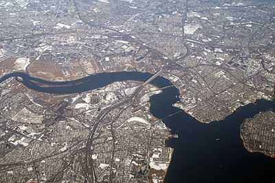
The Raritan river at its mouth at Raritan Bay, an arm of the Upper New York Bay

This is a list of road/highway and rail crossings of the Raritan River from the mouth at Raritan Bay upstream.

This transport-related list is incomplete; you can help by expanding it.

Crossings

Crossing Carries Location Coordinates
Raritan Bay Drawbridge NJ Transit North Jersey Coast Line
Norfolk Southern Railway
CSX
40°29′46″N 74°16′52″W / 40.4961°N 74.2810°W
Victory Bridge NJ 35 40°30′28″N 74°17′31″W / 40.5077°N 74.2919°W
Edison Bridge US 9 North 40°30′32″N 74°18′03″W / 40.5090°N 74.3007°W
Ellis S. Vieser Memorial Bridge US 9 South 40°30′32″N 74°18′05″W / 40.5088°N 74.3014°W
Driscoll Bridge Garden State Parkway 40°30′33″N 74°18′05″W / 40.5093°N 74.3013°W
Basilone Bridge I-95
New Jersey Turnpike
40°29′18″N 74°23′47″W / 40.4884°N 74.3963°W
Morris Goodkind Bridge US 1 North 40°29′34″N 74°24′46″W / 40.4927°N 74.4127°W
Donald Goodkind Bridge US 1 South 40°29′33″N 74°24′47″W / 40.4926°N 74.4131°W
Albany Street Bridge NJ 27
County Route 514
40°29′51″N 74°26′16″W / 40.4975°N 74.4377°W
Northeast Corridor Bridge Amtrak Northeast Corridor
NJ Transit Northeast Corridor Line
40°30′04″N 74°26′27″W / 40.5011°N 74.4409°W
John A. Lynch, Sr. Memorial Bridge NJ 18 40°30′30″N 74°27′31″W / 40.5084°N 74.4586°W
Landing Lane Bridge County Route 609 40°30′31″N 74°27′50″W / 40.5086°N 74.4638°W
I-287 40°32′23″N 74°30′43″W / 40.5397°N 74.5119°W
Rail bridge (abandoned) Rail 40°33′32″N 74°31′26″W / 40.5588°N 74.5240°W
Queen's Bridge County Route 527 40°33′35″N 74°31′40″W / 40.5596°N 74.5278°W
I-287 40°33′15″N 74°32′40″W / 40.5542°N 74.5445°W
Rail bridges Rail 40°32′59″N 74°34′07″W / 40.5497°N 74.5687°W
Rail bridge Rail 40°33′06″N 74°34′19″W / 40.5518°N 74.5720°W
Rail bridge (abandoned) Rail 40°33′10″N 74°34′31″W / 40.5527°N 74.5754°W
Van Veghten's Bridge County Route 533 40°33′19″N 74°35′00″W / 40.5553°N 74.5832°W
US 206 40°33′22″N 74°36′57″W / 40.5562°N 74.6159°W
Nevius Street Bridge Pedestrian Bridge 40°33′53″N 74°38′09″W / 40.5646°N 74.6357°W
John Basilone Veterans Memorial Bridge County Route 625 40°33′53″N 74°38′12″W / 40.5647°N 74.6368°W