List of bridges on the National Register of Historic Places in Oregon
This is a list of bridges and tunnels on the National Register of Historic Places in the U.S. state of Oregon.[1]
Gray shading indicates that a structure has been removed from the Register. Often the road listed in the "location" column now parallels the bridge on a new one, and the old bridge is closed to traffic.
| Name | Image | Built | Listed | Location | County | Type |
|---|---|---|---|---|---|---|
| Belknap Bridge | 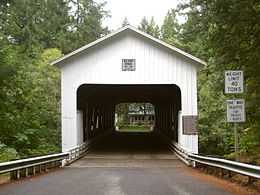 |
1966 | 1979-11-29 | McKenzie River, Rainbow 44°10′05″N 122°13′41″W / 44.168°N 122.228°W |
Lane | Covered Howe truss |
| Big Creek Bridge No. 01180 |  |
1931 | 2005-08-05 | US 101 over Big Creek, north of Florence 44°10′26″N 124°06′54″W / 44.174°N 124.115°W |
Lane | |
| Broadway Bridge | 1913 | 2012-11-14 | Willamette R. at RM 11.7, Portland 45°31′55″N 122°40′26″W / 45.531816°N 122.673898°W |
Multnomah | Willamette River Highway Bridges of Portland, Oregon MPS | |
| Burnside Bridge | 1926 | 2012-11-14 | Willamette R. at RM 12.7, Portland 45°31′23″N 122°40′03″W / 45.523037°N 122.667632°W |
Multnomah | Willamette River Highway Bridges of Portland, Oregon MPS | |
| Cape Creek Bridge No. 01113 | 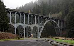 |
1932 | 2005-08-05 | US 101 over Cape Creek, north of Florence 44°07′59″N 124°07′19″W / 44.133°N 124.122°W |
Lane | |
| Chambers Bridge |  |
1936 | 1979-11-29 | Tyler Avenue over Coast Fork Willamette River, Cottage Grove 43°47′20″N 123°04′12″W / 43.789°N 123.070°W |
Lane | Covered Howe truss |
| Chitwood Bridge |  |
ca. 1930 | 1979-11-29 | Chitwood Road over Yaquina River, Chitwood 44°39′14″N 123°49′05″W / 44.654°N 123.818°W |
Lincoln | Covered Howe truss |
| Coos Bay Bridge No. 01823 | 1936 | 2005-08-05 | US 101 over Coos Bay, North Bend 43°25′34″N 124°13′19″W / 43.426°N 124.222°W |
Coos | ||
| Coyote Creek Bridge | .jpg) |
1922 | 1979-11-29 | Coyote Creek Road over Coyote Creek, south of Crow 43°58′12″N 123°19′08″W / 43.970°N 123.319°W |
Lane | Covered Howe truss |
| Crabtree Creek-Hoffman Covered Bridge | 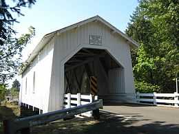 |
1936 | 1987-02-17 | Hungry Hill Road over Crabtree Creek, north of Crabtree 44°39′11″N 122°53′24″W / 44.653°N 122.890°W |
Linn | Covered Howe truss |
| Crawfordsville Bridge | 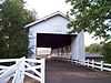 |
1932 | 1979-11-29 | OR 228 over Calapooia River, Crawfordsville 44°21′29″N 122°51′36″W / 44.358°N 122.860°W |
Linn | Covered Howe truss |
| Currin Bridge |  |
1925 | 1979-11-29 | Layng Road over Row River, east of Cottage Grove 43°47′35″N 122°59′46″W / 43.793°N 122.996°W |
Lane | Covered Howe truss |
| Deadwood Creek Bridge | .jpg) |
1932 | 1979-11-29 | Deadwood Loop over Deadwood Creek, north of Deadwood 44°08′38″N 123°43′12″W / 44.144°N 123.720°W |
Lane | Covered Howe truss |
| Depoe Bay Bridge No. 01388 | 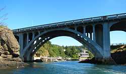 |
1927 | 2005-08-05 | US 101 over Depoe Bay, Depoe Bay 44°48′36″N 124°03′43″W / 44.810°N 124.062°W |
Lincoln | |
| Dorena Bridge |  |
1949 | 1979-11-29 | Shoreview Drive over Row River, north of Dorena 43°44′13″N 122°53′02″W / 43.737°N 122.884°W |
Lane | Covered Howe truss |
| Earnest Bridge | _(lanDA0022a).jpg) |
1938 | 1979-11-29 | Paschelke Road over Mohawk River, north of Marcola 44°12′04″N 122°50′10″W / 44.201°N 122.836°W |
Lane | Covered Howe truss |
| Fisher School Bridge | 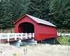 |
1925 | 1979-11-29 | East Crab Creek Road over Five Rivers, Fisher 44°17′31″N 123°50′28″W / 44.292°N 123.841°W |
Lincoln | Covered Howe truss |
| Gallon House Bridge |  |
1916 | 1979-11-29 | Gallon House Road over Abiqua Creek, northwest of Silverton 45°01′55″N 122°47′53″W / 45.032°N 122.798°W |
Marion | Covered Howe truss |
| Goodpasture Bridge |  |
1938 | 1979-11-29 | Goodpasture Road over McKenzie River, west of Vida 44°08′53″N 122°35′17″W / 44.148°N 122.588°W |
Lane | Covered Howe truss |
| Grave Creek Bridge | .jpg) |
1920 | 1979-11-29 | Sunny Valley Loop over Grave Creek, Sunny Valley 42°38′10″N 123°22′41″W / 42.636°N 123.378°W |
Josephine | Covered Howe truss |
| Hannah Bridge |  |
1936 | 1979-11-29 | Camp Morrison Drive over Thomas Creek, east of Scio 44°42′43″N 122°43′08″W / 44.712°N 122.719°W |
Linn | Covered Howe truss |
| Harris Bridge | 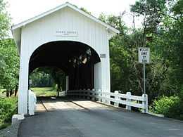 |
1936 | 1979-11-29 | Harris Road over Marys River, Harris 44°34′48″N 123°27′36″W / 44.580°N 123.460°W |
Benton | Covered Howe truss |
| Hawthorne Bridge | _from_southwest%2C_2012.jpg) |
1910 | 2012-11-14 | Willamette R. at RM 13.1, Portland 45°30′48″N 122°40′15″W / 45.513204°N 122.670937°W |
Multnomah | Willamette River Highway Bridges of Portland, Oregon MPS |
| Hayden Bridge |  |
1918 | 1979-11-29 | Hayden Road over Alsea River, west of Alsea 44°22′59″N 123°37′52″W / 44.383°N 123.631°W |
Benton | Covered Howe truss |
| Irish Bend Bridge | 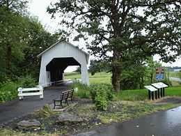 |
1954 | 2013-03-27 | Campus Way over Oak Creek, Corvallis 44°34′01″N 123°18′04″W / 44.567°N 123.301°W (moved from Irish Bend Road northeast of Monroe) |
Benton | Covered Howe truss |
| Lake Creek Bridge | .jpg) |
1928 | 1979-11-29 | Chickahominy Road over Lake Creek, south of Greenleaf 44°06′14″N 123°40′26″W / 44.104°N 123.674°W |
Lane | Covered Howe truss |
| Larwood Bridge | 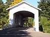 |
1939 | 1979-11-29 | Fish Hatchery Drive over Crabtree Creek, Larwood 44°37′48″N 122°44′28″W / 44.630°N 122.741°W |
Linn | Covered Howe truss |
| Longview Bridge | 1929, 1930 | 1982-07-16 | Columbia River, Rainier 46°06′18″N 122°57′43″W / 46.105°N 122.962°W |
Columbia | Cantilever bridge | |
| Lost Creek Bridge |  |
1919 | 1979-11-29 | Lost Creek Road over Lost Creek, southeast of Lake Creek 42°22′48″N 122°34′48″W / 42.380°N 122.580°W |
Jackson | Covered modified queenpost truss |
| Lowell Bridge |  |
1945, 1947, 1953 | 1979-11-29 | Pioneer Street over Dexter Lake, south of Lowell 43°54′32″N 122°46′44″W / 43.909°N 122.779°W |
Lane | Covered Howe truss |
| McKee Bridge | 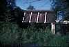 |
1917 | 1979-11-29 | McKee Branch Road over Applegate River, south of Ruch 42°07′34″N 123°04′23″W / 42.126°N 123.073°W |
Jackson | Covered Howe truss |
| Milo Academy Bridge | _(douDA0022).jpg) |
1962 | 1979-11-29 | Milo Drive over South Umpqua River, Milo 42°56′06″N 123°02′20″W / 42.935°N 123.039°W |
Douglas | Covered |
| Morrison Bridge | 1958 | 2012-11-14 | Willamette R. at RM 12.8, Portland 45°30′48″N 122°40′15″W / 45.513204°N 122.670937°W |
Multnomah | Willamette River Highway Bridges of Portland, Oregon MPS | |
| Mosby Creek Bridge |  |
1920 | 1979-11-29 | Layng Road over Mosby Creek, east of Cottage Grove 43°46′41″N 123°00′18″W / 43.778°N 123.005°W |
Lane | Covered Howe truss |
| North Fork of the Yachats Bridge | 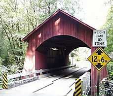 |
1938 | 1979-11-29 | North Yachats River Road over North Fork Yachats River, east of Yachats 44°18′36″N 123°58′12″W / 44.310°N 123.97°W |
Lincoln | Covered queenpost truss |
| Office Bridge |  |
1944 | 1979-11-29 | Westoak Road over North Fork Middle Fork Willamette River, Westfir 43°45′29″N 122°29′46″W / 43.758°N 122.496°W |
Lane | Covered Howe truss |
| Oregon Railway and Navigation Company Bridge | .jpg) |
1887, 1907 | 1980-03-13 | McKenzie River south of Coburg 44°06′47″N 123°02′49″W / 44.113°N 123.047°W |
Lane | |
| Parvin Bridge | _1921.jpg) |
1921 | 1979-11-29 | Anthony Creek Road over Lost Creek, south of Dexter 43°53′56″N 122°49′23″W / 43.899°N 122.823°W |
Lane | Covered Howe truss |
| Pengra Bridge | %2C_Jasper_vicinity_(Lane_County%2C_Oregon).jpg) |
1938 | 1979-11-29 | Place Road over Fall Creek, southeast of Jasper 43°57′58″N 122°50′42″W / 43.966°N 122.845°W |
Lane | Covered Howe truss |
| Portland and Southwestern Railroad Tunnel |  |
1910, 1920, 1921 | 1981-08-17 | Proposed Crown Zellerbach Trail, west of Chapman 45°49′59″N 123°02′49″W / 45.833°N 123.047°W |
Columbia | |
| Portland–Vancouver Highway Bridge (Interstate Bridge) | 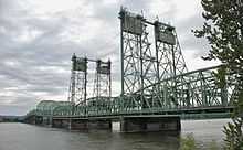 |
1915–1917 | 1982-07-16 | I-5 over Columbia River, north of Portland 45°37′12″N 122°40′26″W / 45.620°N 122.674°W |
Multnomah | Steel truss with vertical-lift section |
| Ritner Creek Bridge | 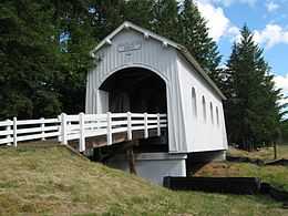 |
1927, 1976 | 1979-11-29 | OR 223 over Ritner Creek, Ritner 44°43′41″N 123°26′31″W / 44.728°N 123.442°W |
Polk | Covered Howe truss |
| Rock O' the Range Bridge |  |
1963 | 1979-11-29 | Bowery Lane over Swalley Canal, north of Bend 44°07′19″N 121°17′13″W / 44.122°N 121.287°W |
Deschutes | Covered king post truss |
| Rocky Creek Bridge No. 01089 | 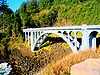 |
1927 | 2005-08-05 | Otter Crest Loop Road (old US 101) over Rocky Creek, south of Depoe Bay 44°46′41″N 124°04′19″W / 44.778°N 124.072°W |
Lincoln | |
| Rogue River Bridge No. 01172 |  |
1932 | 2005-08-05 | US 101 over Rogue River, Gold Beach 42°25′37″N 124°24′47″W / 42.427°N 124.413°W |
Curry | |
| Sandy Creek Bridge |  |
1921 | 1979-11-29 | OR 42 over Sandy Creek, Remote 43°00′22″N 123°53′31″W / 43.006°N 123.892°W |
Coos | Covered Howe truss |
| Short Bridge | 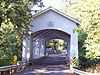 |
1945 | 1979-11-29 | High Deck Road over Santiam River, west of Cascadia 44°23′31″N 122°30′36″W / 44.392°N 122.510°W |
Linn | Covered Howe truss |
| Siuslaw River Bridge No. 01821 | 1936 | 2005-08-05 | US 101 over Siuslaw River, Florence 43°57′54″N 124°06′32″W / 43.965°N 124.109°W |
Lane | ||
| Stewart Bridge |  |
1930 | 1979-11-29 | Garoutte Road over Mosby Creek, southeast of Walden 43°45′58″N 122°59′38″W / 43.766°N 122.994°W |
Lane | Covered Howe truss |
| Stone Bridge and the Oregon Central Military Wagon Road |  |
1867, 1872 | 1974-11-08 | Warner Valley, southeast of Plush 42°21′18″N 119°50′28″W / 42.355°N 119.841°W |
Lake | |
| Ten Mile Creek Bridge No. 01181 |  |
1931 | 2005-08-05 | US 101 over Tenmile Creek, south of Yachats 44°13′26″N 124°06′36″W / 44.224°N 124.110°W |
Lane | |
| Thomas Creek-Gilkey Covered Bridge |  |
1939 | 1987-02-19 | Goar Road over Thomas Creek, north of Crabtree 44°41′17″N 122°54′11″W / 44.688°N 122.903°W |
Linn | Covered Howe truss |
| Thomas Creek-Shimanek Covered Bridge | 1966 | 1987-02-19 | Richardson Gap Road over Thomas Creek, northeast of Scio 44°42′58″N 122°48′14″W / 44.716°N 122.804°W |
Linn | Covered Howe truss | |
| Umpqua River Bridge No. 01822 | 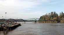 |
1936 | 2005-08-05 | US 101 over Umpqua River, Reedsport 43°42′36″N 124°06′04″W / 43.710°N 124.101°W |
Douglas | |
| Union Street Railroad Bridge and Trestle |  |
1913 | 2006-01-11 | Willamette River, Salem 44°56′49″N 123°02′31″W / 44.947°N 123.042°W |
Marion | Pratt through truss |
| Unity Bridge | .jpg) |
1936, 1975 | 1979-11-29 | Jasper Lowell Road over Fall Creek, Unity 43°56′42″N 122°46′30″W / 43.945°N 122.775°W |
Lane | Covered Howe truss |
| Vista Avenue Viaduct | .jpg) |
1926 | 1984-04-26 | Vista Avenue over Canyon Road, Portland 45°31′08″N 122°41′53″W / 45.519°N 122.698°W |
Multnomah | |
| Wendling Bridge |  |
1938 | 1979-11-29 | Wendling Road over Mill Creek, Wendling 44°11′28″N 122°47′56″W / 44.191°N 122.799°W |
Lane | Covered Howe truss |
| Wildcat Creek Bridge | .jpg) |
1925 | 1979-11-29 | Richardson Upriver Road over Wildcat Creek, Walton 44°00′11″N 123°39′18″W / 44.003°N 123.655°W |
Lane | Covered Howe truss |
| Willamette River (Oregon City) Bridge (No. 357) | _-_1.jpg) |
1922 | 2005-07-01 | OR 43 over Willamette River, Oregon City 45°21′32″N 122°36′36″W / 45.359°N 122.610°W |
Clackamas | Through arch |
| Wilson River Bridge No. 01499 | 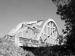 |
1931 | 2005-08-05 | US 101 over Wilson River, north of Tillamook 45°28′41″N 123°50′42″W / 45.478°N 123.845°W |
Tillamook | |
| Yaquina Bay Bridge No. 01820 | 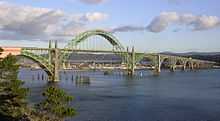 |
1936 | 2005-08-05 | US 101 over Yaquina Bay, Newport 44°37′23″N 124°03′25″W / 44.623°N 124.057°W |
Lincoln | |
| Columbia River Highway Historic District |  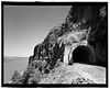 |
1912–1921, 1937[2] | 1983-12-12 | Troutdale to The Dalles | Multnomah, Hood River, Wasco | Multiple bridges and tunnels |
| Antelope Creek Bridge | _(jacDA0027).jpg) |
1922 | 1979-11-29 removed 1988-04-18 |
Main Street over Little Butte Creek, Eagle Point 42°28′19″N 122°48′00″W / 42.472°N 122.800°W (moved) |
Jackson | Covered modified queenpost truss |
| Brumbaugh Bridge | 1948, 1950 | 1979-11-29 removed 1986-11-25 |
Mosby Creek, southeast of Walden (destroyed) |
Lane | Covered Howe truss | |
| Drift Creek Bridge | .jpg) |
1914 | 1979-11-29 removed 1998-07-21 |
Rogers Lane over Bear Creek, southeast of Otis 44°59′35″N 123°53′10″W / 44.993°N 123.886°W (moved from Drift Creek Road over Drift Creek, southeast of Lincoln City) |
Lincoln | Covered Howe truss |
| Elk City Bridge | 1922 | 1979-11-29 removed 1986-11-25 |
Yaquina River, Elk City (destroyed) |
Lincoln | Covered Howe truss | |
| Horse Creek Bridge | .jpg) |
1930 | 1979-11-29 removed 1988-06-27 |
Myrtle Creek, Myrtle Creek 43°01′23″N 123°17′24″W / 43.023°N 123.290°W (moved from Horse Creek Road over Horse Creek, south of McKenzie Bridge) |
Lane | Covered |
| Pumping Station Bridge | 1916 | 1979-11-29 removed 1987-05-18 |
Rickreall Creek, southwest of Ellendale (destroyed) |
Polk | Covered | |
| Roaring Camp Bridge | 1929 | 1979-11-29 removed 1996-01-17 |
Roaring Camp Lane over Elk Creek, west of Drain 43°39′50″N 123°26′24″W / 43.664°N 123.440°W (destroyed) |
Douglas | Covered Howe truss | |
| Sam's Creek Bridge | 1922 | 1979-11-29 removed 1986-11-25 |
Sams Creek Road over Siletz River, east of Siletz 44°43′59″N 123°50′35″W / 44.733°N 123.843°W (destroyed) |
Lincoln | Covered Howe truss | |
| Weddle Bridge | 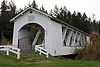 |
1937 | 1979-11-29 removed 1989-01-11 |
Ames Creek in Sweet Home 44°23′42″N 122°43′37″W / 44.395°N 122.727°W (moved from Kelly Road over Thomas Creek southeast of Jefferson) |
Linn | Covered Howe truss |
| Wimer Bridge | 1927, 1962 | 1979-11-29 removed 2006-04-18 |
Covered Bridge Road over Evans Creek, Wimer 42°32′17″N 123°09′00″W / 42.538°N 123.150°W (destroyed and rebuilt) |
Jackson | Covered queenpost truss |
See also
References
- "Oregon National Register List" (PDF). Oregon Parks and Recreation Department. June 6, 2011. Retrieved June 18, 2011. (does not include places no longer listed)
- Oregon National Register List, November 10, 2005. Retrieved June 18, 2011 (includes listed dates of removed places)
- ↑ "National Register Information System". National Register of Historic Places. National Park Service. 2010-07-09.
- ↑ Robert W. Hadlow, Ph.D., Historian, Oregon Department of Transportation, National Historic Landmark Nomination: Columbia River Highway, February 4, 2000, pp. 17-42
External links
![]() Media related to Bridges on the National Register of Historic Places in Oregon at Wikimedia Commons
Media related to Bridges on the National Register of Historic Places in Oregon at Wikimedia Commons