List of airports in Tuvalu

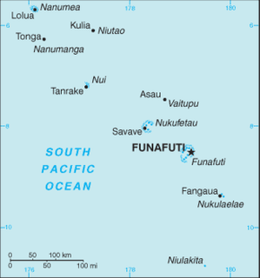
This is a list of airports in Tuvalu.
Tuvalu, formerly known as the Ellice Islands, is a Polynesian island nation located in the Pacific Ocean, midway between Hawaii and Australia. Its nearest neighbours are Kiribati, Nauru, Samoa and Fiji. It comprises four reef islands and five true atolls. Its population of 12,373 makes it the second-least-populated sovereign state in the world, with only Vatican City having fewer inhabitants. In terms of physical land size, at just 26 square kilometres (10 sq mi) Tuvalu is the fourth smallest country in the world, larger only than the Vatican City at 0.44 km2 (0.17 sq mi), Monaco at 1.95 km2 (0.75 sq mi) and Nauru at 21 km2 (8.1 sq mi).
Airports
| Island served | ICAO | IATA | Airport name | Coordinates |
|---|---|---|---|---|
| Funafuti | NGFU | FUN | Funafuti International Airport | 8°31′30″S 179°11′47″E / 8.52500°S 179.19639°E |
| Nanumea | Nanumea airfield (abandoned after World War II) | 5°40′S 176°07′E / 5.667°S 176.117°E | ||
| Motulalo, Nukufetau | Nukufetau airfield (abandoned after World War II) | 8°30′S 178°30′E / 8.500°S 178.500°E |
History
Funafuti Airfield was built by United States Navy Seabee construction battalions in 1943 during World War II.[1] It was later sealed to create Funafuti International Airport.
During World War II the American forces also build airfields on Nanumea and Motulalo, which is the largest atoll of Nukufetau.[2] After the war these two airfields were dismantled.
See also
- Transport in Tuvalu
- List of airports by ICAO code: N#NG - Kiribati (Gilbert Islands), Tuvalu
- Wikipedia:WikiProject Aviation/Airline destination lists: Oceania#Tuvalu
References
- ↑ "To the Central Pacific and Tarawa, August 1943--Background to GALVANIC (Ch 16, p. 622)". 2010. Retrieved 2010-09-03.
- ↑ Melei Telavi, Hugh Laracy (ed.) (1983). "Chapter 18 - War". Tuvalu: A History. Institute of Pacific Studies, University of the South Pacific and Government of Tuvalu. p. 143.
- "ICAO Location Indicators by State" (PDF). International Civil Aviation Organization. 2006-01-12.
- "UN Location Codes: Tuvalu". UN/LOCODE 2009-2. UNECE. 2010-02-08. - includes IATA codes
- Great Circle Mapper: Airports in Tuvalu - IATA and ICAO codes
| ||||||||||||||