List of Ultras of Mexico

The following sortable table lists the 27 ultra-prominent mountain peaks of Mexico.
Topographic elevation is the vertical distance above the reference geoid, a precise mathematical model of the Earth's sea level as an equipotential gravitational surface. Topographic prominence is the elevation difference between the summit and the highest or key col to a higher summit. Topographic isolation is the minimum great circle distance to a point of higher elevation.
This article defines a significant summit as a summit with at least 100 meters (328.1 feet) of topographic prominence, and a major summit as a summit with at least 500 meters (1640.4 feet) of topographic prominence. An ultra-prominent summit is a summit with at least 1500 meters (4921.3 feet) of topographic prominence. The following 27 peaks are the ultra-prominent summits of Mexico.
Of these 27 ultra-prominent summits, 5 are located in Oaxaca, 4 in Puebla, 4 in Nuevo León, 3 in México, 3 in Jalisco, 2 in Michoacán, 2 in Baja California Sur, 2 in Coahuila, and one each in Morelos, Guerrero, Baja California, Tlaxcala, Querétaro, and Veracruz.
Table
Gallery
-
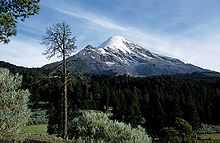
1. The summit of Pico de Orizaba, a stratovolcano on the border between Puebla and Veracruz, is the highest peak of Mexico.
-

2. The summit of Volcán Popocatépetl, a stratovolcano at the junction of Puebla, Mexico State, and Morelos, is the second highest peak of Mexico.
-
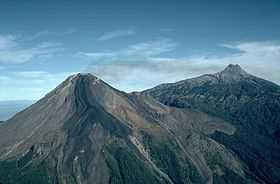
3. Nevado de Colima is a stratovolcano in Colima.
-

4. Nevado de Toluca is a stratovolcano in Mexico State.
-

10. The stratovolcano Matlalcueitl straddles the border between Tlaxcala and Puebla.
-
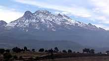
25. The summit of Volcán Iztaccíhuatl, a stratovolcano on the border between Puebla and Mexico State, is the third highest peak of Mexico.
See also
- Outline of Mexico
- Index of Mexico-related articles
- Mexico
- Geography of Mexico
- Category:Mountains of Mexico
- Geography of Mexico
- Physical geography
- Topography
- Topographic elevation
- Topographic isolation
- Topographic prominence
- Topographic summit
- Topography
- Lists of mountains
- Mountain peaks of greater North America
- The 355 ultra-prominent mountain peaks of greater North America
- The 39 ultra-prominent mountain peaks of Greenland
- The 142 ultra-prominent mountain peaks of Canada
- The 129 ultra-prominent mountain peaks of the United States
- The 65 ultra-prominent mountain peaks of Alaska
- The 9 ultra-prominent mountain peaks of California
- The 3 ultra-prominent mountain peaks of Colorado
- The 27 ultra-prominent mountain peaks of México
- The 22 ultra-prominent mountain peaks of Central America
- The 7 ultra-prominent mountain peaks of the Caribbean
- The 355 ultra-prominent mountain peaks of greater North America
- Mountain peaks of Greenland
- Mountain peaks of Canada
- Mountain peaks of the Rocky Mountains
- Mountain peaks of the United States
- Mountain peaks of Alaska
- Mountain peaks of California
- Mountain peaks of Colorado
- Mountain peaks of México
- The 27 Ultra-prominent mountain peaks of México
- Mountain peaks of Central America
- Mountain peaks of the Caribbean
- Mountain peaks of greater North America
References
- ↑ Volcán Citlaltépetl is the highest point of Estado Libre y Soberano de Puebla, Estado Libre y Soberano de Veracruz de Ignacio de la Llave, and all of México
- ↑ "Volcán Citlaltépetl". Summits of the World. peakbagger.com. Retrieved January 2, 2010.
- ↑ Volcán Popocatépetl on the border of Estado Libre y Soberano de Puebla is the highest point of both Estado Libre y Soberano de México and Estado Libre y Soberano de Morelos.
- ↑ "Volcán Popocatépetl". Summits of the World. peakbagger.com. Retrieved January 2, 2010.
- ↑ Nevado de Colima is the highest point of Estado Libre y Soberano de Jalisco
- ↑ "Nevado de Colima". Summits of the World. peakbagger.com. Retrieved January 2, 2010.
- ↑ "Nevado de Toluca". Summits of the World. peakbagger.com. Retrieved January 2, 2010.
- ↑ Cerro Tiotepec is the highest point of Estado Libre y Soberano de Guerrero
- ↑ "Cerro Tiotepec". Summits of the World. peakbagger.com. Retrieved January 10, 2010.
- ↑ "Cerro El Nacimiento". Summits of the World. peakbagger.com. Retrieved January 10, 2010.
- ↑ Picacho del Diablo is the highest point of Estado Libre y Soberano de Baja California
- ↑ "Picacho del Diablo". Summits of the World. peakbagger.com. Retrieved January 10, 2010.
- ↑ Cerro Nube is the highest point of the Sierra Madre del Sur and Estado Libre y Soberano de Oaxaca
- ↑ "Cerro Nube". Summits of the World. peakbagger.com. Retrieved January 10, 2010.
- ↑ "Cerro Las Conchas". Summits of the World. peakbagger.com. Retrieved January 10, 2010.
- ↑ Volcán Matlalcuéyetl on the border of Estado Libre y Soberano de Puebla is the highest point of Estado Libre y Soberano de Tlaxcala
- ↑ "Volcán Matlalcuéyetl". Summits of the World. peakbagger.com. Retrieved January 2, 2010.
- ↑ Sierra La Laguna High Point is the highest point in Estado Libre y Soberano de Baja California Sur
- ↑ "Sierra La Laguna High Point". Summits of the World. peakbagger.com. Retrieved January 2, 2010.
- ↑ "Sierra La Madera". Summits of the World. peakbagger.com. Retrieved January 10, 2010.
- ↑ "Cerro Tia Chena". Summits of the World. peakbagger.com. Retrieved January 3, 2010.
- ↑ "Cerro El Potosí". Summits of the World. peakbagger.com. Retrieved January 10, 2010.
- ↑ "Cerro La Joya". Summits of the World. peakbagger.com. Retrieved January 10, 2010.
- ↑ Volcán Tancítaro is the highest point of Estado Libre y Soberano de Michoacán de Ocampo
- ↑ "Volcán Tancítaro". Summits of the World. peakbagger.com. Retrieved January 2, 2010.
- ↑ "Picacho San Onofre". Summits of the World. peakbagger.com. Retrieved January 3, 2010.
- ↑ "Cerro El Centinela". Summits of the World. peakbagger.com. Retrieved January 10, 2010.
- ↑ "El Aguacate Oeste". Summits of the World. peakbagger.com. Retrieved January 3, 2010.
- ↑ "Volcán Las Tres Vírgenes". Summits of the World. peakbagger.com. Retrieved January 2, 2010.
- ↑ "Sierra de Santa Martha". Summits of the World. peakbagger.com. Retrieved January 2, 2010.
- ↑ "Cerro Las Capillas". Summits of the World. peakbagger.com. Retrieved January 11, 2010.
- ↑ "Picachos El Fraile". Summits of the World. peakbagger.com. Retrieved January 11, 2010.
- ↑ "Cerro Zempoaltepetl". Summits of the World. peakbagger.com. Retrieved January 10, 2010.
- ↑ "Volcán Iztaccíhuatl". Summits of the World. peakbagger.com. Retrieved January 2, 2010.
- ↑ "Volcán de Tequila". Summits of the World. peakbagger.com. Retrieved January 11, 2010.
- ↑ "Sierra El Cerro Azul". Summits of the World. peakbagger.com. Retrieved January 10, 2010.
External links
- Natural Resources Mexico (NRC)
- peakbagger.com
- peaklist.org
- summitpost.org
- World Mountain Encyclopedia @ peakware.com
| ||||||||||
| ||||||||||||||||||