List of Ramsar sites in Australia
This is a list of wetlands in Australia that are designated by the Ramsar Convention as sites of international importance. Under the Convention, the wetlands are conisdered as being of significant value not only for the Australian community, but for humanity as a whole.
The Ramsar Convention on Wetlands came into force for Australia on 21 December 1975. Since that date, Australia has 65 sites designated as Wetlands of International Importance, with a total area of 8,319,886 hectares (20,558,890 acres).[1][2]
Wetlands in the Australian Capital Territory
The following wetlands are located in the Australian Capital Territory:[1]
| Name | Location | Coordinates | Area | Designated | Designation No. | Description[2] | Image |
|---|---|---|---|---|---|---|---|
| Ginini Flats Subalpine Bog Complex | Namadgi National Park | 35°31′S 148°46′E / 35.517°S 148.767°E | 125 ha (309 acres) | 11 March 1996 | RS793 |
Wetlands in New South Wales
The following wetlands are located in New South Wales:[1]


Wetlands in the Northern Territory
The following wetlands are located in the Northern Territory:[1]
| Name | Location | Coordinates | Area | Designated | Designation No. | Description[2] | Image |
|---|---|---|---|---|---|---|---|
| Cobourg Peninsula | Garig Gunak Barlu National Park | 11°15′S 132°15′E / 11.250°S 132.250°E | 220,700 hectares (545,000 acres) | 8 May 1974 | RS1 | 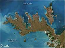 | |
| Kakadu National Park (Stage 1) | Alligator Rivers, Kakadu National Park | 12°40′S 132°45′E / 12.667°S 132.750°E | 683,000 hectares (1,690,000 acres) | 12 June 1980 | RS204 | 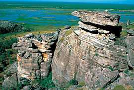 | |
| Kakadu National Park (Stage 2) | 12°30′S 132°30′E / 12.500°S 132.500°E | 692,940 hectares (1,712,300 acres) | 15 September 1989 | RS441 | |||
Wetlands in Queensland
The following wetlands are located in Queensland:[1]
| Name | Location | Coordinates | Area | Designated | Designation No. | Description[2] | Image |
|---|---|---|---|---|---|---|---|
| Bowling Green Bay | North Queensland | 19°27′S 147°15′E / 19.450°S 147.250°E | 35,500 hectares (88,000 acres) | 22 October 1993 | RS632 | ||
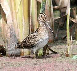
| Currawinya Lakes | South West Queensland | 28°45′S 144°19′E / 28.750°S 144.317°E | 151,300 hectares (374,000 acres) | 11 March 1996 | RS791 |  | |
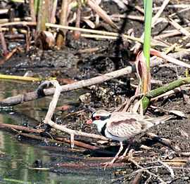
| Great Sandy Strait | Wide Bay–Burnett | 25°28′S 152°54′E / 25.467°S 152.900°E | 93,160 hectares (230,200 acres) | 14 June 1999 | RS992 |  | |
| Moreton Bay | South East Queensland | 27°20′S 153°10′E / 27.333°S 153.167°E | 113,314 hectares (280,000 acres) | 22 October 1993 | RS631 |  | |
| Shoalwater and Corio Bays | Central Queensland | 22°40′S 150°17′E / 22.667°S 150.283°E | 239,100 hectares (591,000 acres) | 11 March 1996 | RS792 |  |
Wetlands in South Australia
The following wetlands are located in South Australia:[1]
| Name | Location | Coordinates | Area | Designated | Designation No. | Description[2] | Image |
|---|---|---|---|---|---|---|---|
| Banrock Station Wetland Complex | Riverland | 34°11′S 140°20′E / 34.183°S 140.333°E | 1,375 hectares (3,400 acres) | 21 October 2002 | RS1221 |  | |
| Bool and Hacks Lagoons | Limestone Coast | 37°08′S 140°41′E / 37.133°S 140.683°E | 3,200 hectares (7,900 acres) | 1 November 1985 | RS322 |  | |
| Coongie Lakes | Lake Eyre Basin | 27°27′S 140°00′E / 27.450°S 140.000°E | 1,980,000 hectares (4,900,000 acres) | 1 June 1987 | RS376 |  | |
| Coorong and Lakes Alexandrina and Albert Wetland | Younghusband Peninsula | 35°56′S 139°18′E / 35.933°S 139.300°E | 140,500 hectares (347,000 acres) | 1 November 1985 | RS321 |  | |
| Piccaninnie Ponds Karst Wetlands | Limestone Coast | 38°3′3″S 140°56′11″E / 38.05083°S 140.93639°E | 862 hectares (2,130 acres)[3] | 21 December 2012 | RS2136 | ||
| Riverland | Riverland | 34°02′S 140°51′E / 34.033°S 140.850°E | 30,600 hectares (76,000 acres) | 23 September 1987 | RS377 |
Wetlands in Tasmania
The following wetlands are located in Tasmania:[1]
| Name | Location | Coordinates | Area | Designated | Designation No. | Description[2] | Image |
|---|---|---|---|---|---|---|---|
| Apsley Marshes | Freycinet Peninsula | 41°56′S 148°12′E / 41.933°S 148.200°E | 880 hectares (2,200 acres) | 16 November 1982 | RS255 | ||
| Cape Barren Island, east coast lagoons | Furneaux Group | 40°22′S 148°23′E / 40.367°S 148.383°E | 4,370 hectares (10,800 acres) | 16 November 1982 | RS255 | 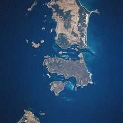 | |
| Interlaken Lakeside Reserve | Central Highlands | 42°09′S 147°10′E / 42.150°S 147.167°E | 520 hectares (1,300 acres) | 16 November 1982 | RS259 | ||
| Jocks Lagoon | St Helens | 41°21′S 148°18′E / 41.350°S 148.300°E | 18 hectares (44 acres) | 16 November 1982 | RS258 | ||
| Lavinia Nature Reserve | King Island | 39°45′S 144°05′E / 39.750°S 144.083°E | 7,020 hectares (17,300 acres) | 16 November 1982 | RS253 | ||
| Little Waterhouse Lake | North East | 40°52′S 147°37′E / 40.867°S 147.617°E | 57 hectares (140 acres) | 16 November 1982 | RS260 | 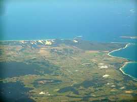 | |
| Logan Lagoon | Flinders Island, Furneaux Group | 40°10′S 148°17′E / 40.167°S 148.283°E | 2,320 hectares (5,700 acres) | 16 November 1982 | RS252 | ||
| Lower Ringarooma River | North East | 40°54′S 147°56′E / 40.900°S 147.933°E | 4,160 hectares (10,300 acres) | 16 November 1982 | RS257 | 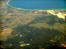 | |
| Moulting Lagoon Nature Reserve | Freycinet Peninsula | 42°05′S 148°10′E / 42.083°S 148.167°E | 4,580 hectares (11,300 acres) | 16 November 1982 | RS251 | ||
| Pittwater-Orielton Lagoon | Southern Tasmania | 42°48′S 147°30′E / 42.800°S 147.500°E | 3,175 hectares (7,850 acres) | 16 November 1982 | RS254 |
Wetlands in Victoria
The following wetlands are located in Victoria:[1]
| Name | Location | Coordinates | Area | Designated | Designation No. | Description[2] | Image |
|---|---|---|---|---|---|---|---|
| Barmah Forest | Goulburn Valley, Hume | 35°55′S 145°08′E / 35.917°S 145.133°E | 28,515 hectares (70,460 acres) | 15 December 1982 | RS262 | ||
| Corner Inlet | South Gippsland | 38°45′S 146°32′E / 38.750°S 146.533°E | 67,186 hectares (166,020 acres) | 15 December 1982 | RS261 | ||
| Edithvale-Seaford Wetlands | Port Phillip | 38°04′S 145°07′E / 38.067°S 145.117°E | 261 hectares (640 acres) | 29 August 2001 | RS1096 |  | |
| Gippsland Lakes | East Gippsland | 38°00′S 147°36′E / 38.000°S 147.600°E | 60,015 hectares (148,300 acres) | 15 December 1982 | RS269 | ||
| Gunbower Forest | 35°49′S 144°19′E / 35.817°S 144.317°E | 19,931 hectares (49,250 acres) | 15 December 1982 | RS263 | |||
| Hattah-Kulkyne Lakes | Murray Mallee | 34°41′S 142°26′E / 34.683°S 142.433°E | 955 hectares (2,360 acres) | 15 December 1982 | RS264 |  | |
| Kerang Wetlands | Murray Mallee | 35°40′S 143°56′E / 35.667°S 143.933°E | 9,419 hectares (23,270 acres) | 15 December 1982 | RS265 | ||
| Lake Albacutya | Wimmera | 35°46′S 141°58′E / 35.767°S 141.967°E | 5,731 hectares (14,160 acres) | 15 December 1982 | RS270 | ||
| Port Phillip Bay and Bellarine Peninsula | Port Phillip, Bellarine Peninsula | 38°04′S 144°36′E / 38.067°S 144.600°E | 22,897 hectares (56,580 acres) | 15 December 1982 | RS266 | ||
| Western District Lakes | Western District | 38°10′S 143°31′E / 38.167°S 143.517°E | 32,898 hectares (81,290 acres) | 15 December 1982 | RS268 | ||
| Western Port Bay | Western Port | 38°22′S 145°17′E / 38.367°S 145.283°E | 59,297 hectares (146,530 acres) | 15 December 1982 | RS267 | ||
Wetlands in Western Australia
The following wetlands are located in Western Australia:[1]
| Name | Location | Coordinates | Area | Designated | Designation No. | Description[2] | Image |
|---|---|---|---|---|---|---|---|
| Becher Point Wetlands | Swan Coastal Plain | 32°23′S 115°44′E / 32.383°S 115.733°E | 677 hectares (1,670 acres) | 5 January 2001 | RS1048 | ||
| Eighty Mile Beach | Kimberley | 19°31′S 120°40′E / 19.517°S 120.667°E | 125,000 hectares (310,000 acres) | 7 June 1990 | RS480 |  | |
| Forrestdale and Thomsons Lakes | Swan Coastal Plain | 32°09′S 115°52′E / 32.150°S 115.867°E | 754 hectares (1,860 acres) | 7 June 1990 | RS481 | ||
| Lake Gore | Goldfields-Esperance | 33°47′S 121°29′E / 33.783°S 121.483°E | 4,017 hectares (9,930 acres) | 5 January 2001 | RS1049 | ||
| Lake Warden System | Goldfields-Esperance | 33°48′S 121°56′E / 33.800°S 121.933°E | 2,300 hectares (5,700 acres) | 7 June 1990 | RS485 |  | |
| Lakes Argyle and Kununurra | Kimberley | 16°19′S 128°44′E / 16.317°S 128.733°E | 150,000 hectares (370,000 acres) | 7 June 1990 | RS478 |  | |
| Muir-Byenup System | South West | 34°29′S 116°43′E / 34.483°S 116.717°E | 10,631 hectares (26,270 acres) | 5 January 2001 | RS1050 |  | |
| Ord River Floodplain | Kimberley | 15°15′S 128°22′E / 15.250°S 128.367°E | 141,453 hectares (349,540 acres) | 7 June 1990 | RS477 |  | |
| Peel-Yalgorup System | Swan Coastal Plain | 32°49′S 115°42′E / 32.817°S 115.700°E | 26,530 hectares (65,600 acres) | 7 June 1990 | RS482 | ||
| Roebuck Bay | Kimberley | 18°07′S 122°16′E / 18.117°S 122.267°E | 55,000 hectares (140,000 acres) | 7 June 1990 | RS479 |  | |
| Toolibin Lake | Wheatbelt | 32°55′S 117°36′E / 32.917°S 117.600°E | 493 hectares (1,220 acres) | 7 June 1990 | RS483 | ||
| Vasse-Wonnerup System | South West | 33°37′S 115°25′E / 33.617°S 115.417°E | 1,115 hectares (2,760 acres) | 7 June 1990 | RS484 |  |
Wetlands in the External territories
The following wetlands are located in the External territories:[1]
| Name | Location | Coordinates | Area | Designated | Designation No. | Description[2] | Image |
|---|---|---|---|---|---|---|---|
| Ashmore Reef National Nature Reserve | Ashmore and Cartier Islands | 12°15′S 123°02′E / 12.250°S 123.033°E | 58,300 hectares (144,000 acres) | 21 October 2002 | RS1220 | ||
| Coral Sea Reserves (Coringa-Herald and Lihou Reef and Cays) | Coral Sea Islands Territory | 17°04′S 150°39′E / 17.067°S 150.650°E | 1,729,200 hectares (4,273,000 acres) | 21 October 2002 | RS1222 | ||
| The Dales | Christmas Island | 10°28′S 105°33′E / 10.467°S 105.550°E | 57 hectares (140 acres) | 21 October 2002 | RS1225 | ||
| Elizabeth and Middleton Reefs Marine National Nature Reserve | Coral Sea Islands Territory | 29°41′S 159°06′E / 29.683°S 159.100°E | 188,000 hectares (460,000 acres) | 21 October 2002 | RS1223 |  | |
| Hosnies Spring | Christmas Island | 10°28′S 105°41′E / 10.467°S 105.683°E | 1 hectare (2.5 acres) | 11 December 1990 | RS512 | ||
| Pulu Keeling National Park | Cocos (Keeling) Islands | 11°50′S 96°49′E / 11.833°S 96.817°E | 122 hectares (300 acres) | 17 March 1996 | RS797 |  |
See also
- Environment Protection and Biodiversity Conservation Act 1999
- List of Ramsar sites worldwide
- Ramsar Convention
References
- ↑ 1.0 1.1 1.2 1.3 1.4 1.5 1.6 1.7 1.8 1.9 "The List of Wetlands of International Importance" (PDF) (PDF). The Ramsar Convention on Wetlands. 19 June 2014. Retrieved 28 June 2014.
- ↑ 2.0 2.1 2.2 2.3 2.4 2.5 2.6 2.7 2.8 2.9 "The Annotated Ramsar List: Australia". The Annotated Ramsar List of Wetlands of International Importance. The Ramsar Convention on Wetlands. 10 April 2013. Retrieved 28 June 2014.
- ↑ Peddie, Clare. "Piccaninnie Ponds now a wetland world wonder". The Advertiser. Retrieved 24 January 2013.