|
Marker name[1] |
Image |
Date designated |
Location |
City or Town |
Coords |
Marker text |
|---|
| 1 |
Home of Philip D. Dater |
 |
02007-01-01-00002007 |
Brunswick Road (New York State Route 2) in Eagle Mills |
Brunswick |
42°43′45.29″N 73°36′2.61″W / 42.7292472°N 73.6007250°W / 42.7292472; -73.6007250 |
1798: Home Of Philip D. Dater. Born 1790-Died 1868. Served in War of 1812 |
| 2 |
Garfield School |
 |
02015-01-01-0000 |
Garfield Road near Brunswick Road (New York State Route 2) |
Brunswick |
42°43′43.27″N 73°35′59.74″W / 42.7286861°N 73.5999278°W / 42.7286861; -73.5999278 |
1-Room c. 1840-81. Named for James A. Garfield who taught here 1854-56 while a student at Williams College |
| 3 |
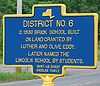
District No. 6 |
 |
02009-01-01-00002009 |
Corner of Buck Road and Brick Church Road (New York State Route 278) |
Brunswick |
42°45′4.4″N 73°34′27.67″W / 42.751222°N 73.5743528°W / 42.751222; -73.5743528 |
C. 1830 brick school built on land granted by Luther and Olive Eddy. Later named the Lincoln School by students. |
| 4 |
Gilead Lutheran Church |
 |
01947-01-01-00001947 |
New York State Route 7 at Haynersville |
Brunswick |
42°47′27.78″N 73°34′13.47″W / 42.7910500°N 73.5704083°W / 42.7910500; -73.5704083 |
Gilead Church; Lutheran, organized about 1746 by Palatine settlers 400 feet east of this spot. Moved 2½ miles south to present site in 1817. |
| 4 |
District 7 School |
 |
02015-01-01-0000 |
Gypsy Lane of New York State Route 142 near Lansingburgh |
Brunswick |
42°46′43.41″N 73°38′43.27″W / 42.7787250°N 73.6453528°W / 42.7787250; -73.6453528 |
Dist. 7 School; On Gypsy Lane c. 1829–30; 'Schoolhouse in the woods'; Herman Melville taught 1840; Land given 1829 by Abraham Jacob Lansing. |
| 5 |
Citizen Genet |
|
02015-01-01-0000 |
On Us 9 & 20 In Front Of Dutch Reformed Church, E. Greenbush |
East Greenbush |
|
1763–1834 Settled Two Miles West Of Here About 1800 Grave Behind This Church |
| 6 |
War of 1812 |
|
02015-01-01-0000 |
On Us 9 & 20 Columbia Trnpke. At Hampton Manor |
East Greenbush |
|
Greenbush Cantonment Quarters For United States Army Situated On Half Mile North Of Here [Arrow] |
| 7 |
Arrow (Fort Crailo) |
|
02015-01-01-0000 |
Intersection Us 9 & 20 With Nys 4 & 40 |
East Greenbush |
|
4 Miles Fort Crailo "Yankee Doodle" Written There 1758 |
| 8 |
Arrow (Fort Crailo) |
|
02015-01-01-0000 |
Intersection Us 9 & 20 With Nys 9J |
East Greenbush |
|
2500 Feet Fort Crailo "Yankee Doodle" Written There 1758 |
| 9 |
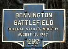
Bennington Battlefield |
 |
01929-01-01-00001929 |
New York State Route 67 at entrance to Bennington Battlefield Park, east of Walloomsac |
Hoosick |
42°56′1.98″N 73°18′17.24″W / 42.9338833°N 73.3047889°W / 42.9338833; -73.3047889 |
Bennington Battlefield; General Stark's Victory; August 16, 1777 |
| 10 |
Early Tavern |
|
02015-01-01-0000 |
On Nys 7 At Hoosick |
Hoosick |
|
Kept By David Wilcox Before 1814. Later Home Of Dr. John Warren. Born 1806, Died 1882 First Regular Pastor 1797 |
| 11 |
First Meeting House |
 |
01936-01-01-00001936 |
East side of Main Street between Elm and Hall Streets in Hoosick Falls |
Hoosick |
42°53′56.32″N 73°21′1.31″W / 42.8989778°N 73.3503639°W / 42.8989778; -73.3503639 |
First Meeting House in Hoosick Falls erected 1800 for use of the "Warren Society of Hoosick"; Baptist church organized 1847. |
| 12 |
Reformed Protestant Dutch Church at Tiossiook |
 |
01936-01-01-00001936 |
Southeast corner of New York State Route 67 and Buskirk-West Hoosick Road |
Hoosick |
42°57′12.49″N 73°26′0.09″W / 42.9534694°N 73.4333583°W / 42.9534694; -73.4333583 |
Dutch Church at Tiossiook; Organized May 2, 1792; Present building erected 1823; First pastor Rev. S. Smith |
| 13 |
Walloomsac N. E. Church |
|
02015-01-01-0000 |
On Town Rd. About 1 Mile East Of Walloomsac |
Hoosick |
|
Walloomsac N. E. Church Incorporated April 18, 1811 Reincorporated 1845 And 1858 On Pittstown Circuit Church Building Removed 1898 |
| 14 |
First Bridge Over Hoosick River in Hoosick Falls |
|
02015-01-01-0000 |
On Mechanic St., Hoosick Falls |
Hoosick |
|
First Bridge Over Hoosick River At The Falls, Built 1791 As "Federal Bridge". Builders John Waldo And John Ryan Rebuilt By J. Manchester, 1825 |
| 15 |
Hoosick Baptist Church |
|
02015-01-01-0000 |
On Nys 7 About 1½ Miles Northeast Of Hoosick |
Hoosick |
|
Hoosick Baptist Church Organized March 16, 1785 First Building Erected 1792 Elder Samuel Rogers First Regular Pastor 1797 |
| 16 |
St. Croix Church |
 |
02015-01-01-0000 |
On Nys 67 About 1/2 Mile West Of North Hoosick |
Hoosick |
42°55′54.98″N 73°21′31.15″W / 42.9319389°N 73.3586528°W / 42.9319389; -73.3586528 |
Near here is site Dutch Reform Church the first Protestant Church in Hoosick Valley on lot of A. Wendell in Hoosac Pat. |
| 17 |
Arrow (Bennington Battlefield) |
|
02015-01-01-0000 |
On Nys 67 About 1 Mile East Of Walloomsac |
Hoosick |
|
Bennington Battlefield August 16, 1777 Road Leading To Site Of Battle And Baum's Redoubt |
| 18 |
Arrow (Bennington Battlefield) |
|
02015-01-01-0000 |
On Nys 67 About 1 Mile East Of Walloomsac |
Hoosick |
|
Battery Point Here, August 16, 1777 A Cannon, Guarding Bridge And Ford, Was Captured By The Americans. Now In The Bennington Hist. Museum |
| 19 |
Benjamin Budd's Tavern |
|
02015-01-01-0000 |
On Us 20 At Brainerd |
Nassau |
|
Built By Hershon Turner On Site Of Kaunaumeek Where Brainerd Preached To Indians With Aid Of Wauwaumpequunnaunt |
| 20 |
Van Alen Home |
|
02015-01-01-0000 |
On Washington Avenue near New York State Route 43 in Defreestville |
North Greenbush |
42°39′14.44″N 73°41′52.55″W / 42.6540111°N 73.6979306°W / 42.6540111; -73.6979306 |
Built On 400 Acres Tract Purchased 1778 By John Evert Van Alen Born 1749 - Died 1807 Congressman 1793–1799 |
| 21 |
Arrow (Fort Crailo) |
|
02015-01-01-0000 |
On Nys 40 At Defreestville |
North Greenbush |
|
5 Miles Fort Crailo "Yankee Doodle" Written There 1758 |
| 22 |
Brimmer Farm |
|
02015-01-01-0000 |
On Co. Rd. About 1/2 Mile South Of Petersburg Junction |
Petersburg |
|
Settled 1754 Indian Massacre Occurred Here June 2, 1755 George Brimmer Buried Here |
| 23 |
Farm of John Brimmer |
|
02015-01-01-0000 |
On Nys 22 About 1½ Miles South Of Petersburg |
Petersburg |
|
John Brimmer Who Was Captured By Indians, 1754 Buried Here In 1830 |
| 24 |
Coon Inn |
|
02015-01-01-0000 |
On Nys 22 About 1 Mile South Of Petersburg |
Petersburg |
|
Coon Inn First Town Meeting Held Here April 5, 1791. H. Coon, Moderator; J. Odell, Supervisor; J. Greene, Clerk |
| 25 |
Lydia Odell Baxter |
|
02015-01-01-0000 |
On Tn. Rd. About 1½ Miles East Of Petersburg |
Petersburg |
|
Poet Born Here September 2, 1809 - Died New York City, January 23, 1874 |
| 26 |
Reynolds Farm |
|
02015-01-01-0000 |
On Nys 22 About 3 Miles South Of North Petersburg |
Petersburg |
|
Settled 1780 William W. Reynolds Born In Rhode Island Died Here 1829. Served In American Revolution |
| 27 |
Garfield Church |
|
02015-01-01-0000 |
On Town Road To Poestenkill |
Poestenkill |
|
President James A. Garfield Preached Here And Conducted His Writing School Earning Tuition To Williams College |
| 28 |
Arrow (Fort Crailo) |
|
02015-01-01-0000 |
At Columbia St. & Broadway |
Rensselaer |
|
1200 Feet Fort Crailo "Yankee Doodle" Written There 1758 |
| 29 |
Arrow (Fort Crailo) |
|
02015-01-01-0000 |
On Broadway At Dunn Memorial Bridge |
Rensselaer |
|
2000 Feet Fort Crailo "Yankee Doodle" Written There 1758 |
| 30 |
Arrow (Fort Crailo) |
|
02015-01-01-0000 |
At Dunn Memorial Bridge |
Rensselaer |
|
2000 Feet Fort Crailo "Yankee Doodle" Written There 1758 |
| 31 |
Arrow (Fort Crailo) |
|
02015-01-01-0000 |
On Riverside Ave. Opposite Fort Crailo |
Rensselaer |
|
Fort Crailo "Yankee Doodle" Written Here 1758 |
| 32 |
Arrow (Fort Crailo) |
|
02015-01-01-0000 |
At Aiken Ave. & Columbia St. |
Rensselaer |
|
1200 Feet Fort Crailo "Yankee Doodle" Written There 1758 |
| 33 |
Herman Melville's Home |
|
02015-01-01-0000 |
In Front Of No. 2 114Th St. In North Troy |
Troy |
|
Author Of "Moby Dick" Family Home 1838–1847 Did His Earliest Writing And Completed First Two Books Here; "Typee" And "Omoo" |
| 34 |
First House of Worship in Troy |
|
02015-01-01-0000 |
On The Corner Of Congress & 1St Sts. In Troy |
Troy |
|
The First House Of Worship In Troy Was Erected - 1792 By The First Presbyterian Church Present Church Built 1836 |
| 35 |
Albert Pawling |
 |
02015-01-01-0000 |
Old Mount Ida Cemetery on Pawling Avenue, near New York State Route 2 |
Troy |
42°43′17.55″N 73°40′26.81″W / 42.7215417°N 73.6741139°W / 42.7215417; -73.6741139 |
Albert Pawling; 2nd Lt. 1775. Led forces at Quebec, St. John's, White Plains and Monmouth. 1st sheriff Rensselaer County; 1st mayor City of Troy, NY |
| 36 |
Old Mount Ida Cemetery |
 |
02015-01-01-0000 |
Pawling Avenue near New York State Route 2 |
Troy |
42°43′17.15″N 73°40′30.54″W / 42.7214306°N 73.6751500°W / 42.7214306; -73.6751500 |
Old Mount Ida; Cemetery est. 01 Jan 1832; 12-3/10 acres. Numerous soldiers buried here who served in the Revolutionary War, 1812 and Civil Wars |
|