List of National Natural Landmarks in Oregon
From List of National Natural Landmarks, these are the National Natural Landmarks in the U.S. state of Oregon.
| Name | Image | Date | Location | County | Description | |
|---|---|---|---|---|---|---|
| 1 | Crown Point |  | 1971 | 45°32′22″N 122°14′39″W / 45.5395°N 122.24422°W | Multnomah | Promontory in Columbia Gorge |
| 2 | Fort Rock State Monument |  | 1976 | 43°22′19″N 121°04′26″W / 43.372°N 121.074°W | Lake | Volcanic tuff ring |
| 3 | Horse Ridge Natural Area | 1967 | 43°55′26″N 121°02′20″W / 43.924°N 121.039°W[1] | Deschutes | Park[1] | |
| 4 | Lawrence Memorial Grassland Preserve | 1984 | Oregon | An excellent illustration of "biscuit and scabland" topography. | ||
| 5 | Willamette Floodplain | 1987 | 44°21′50″N 123°13′48″W / 44.364°N 123.23°W | Benton, Lane, Linn, Marion, Polk | Floodplain | |
| 6 | Newberry Crater |  | 1976 | 43°41′21″N 121°15′18″W / 43.689194°N 121.254889°W | Deschutes | Atypical shield volcano |
| 7 | John Day Fossil Beds |  | 1966 | Grant | Contains a remarkable sequence of very diverse fossils. | |
| 8 | Round Top Butte | 2011 | Jackson | Exceptional native bunchgrass habitat. | ||
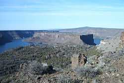
| 9 | The Island |  | 2011 | 44°33′31″N 121°16′38″W / 44.558489°N 121.277143°W | Jefferson | Native juniper savanna on an isolated plateau at the confluence of the Deschutes and Crooked Rivers. |
References
- ↑ 1.0 1.1 "Horse Ridge Natural Area". Geographic Names Information System. United States Geological Survey. Retrieved 2009-04-05.