List of National Natural Landmarks in New York
From List of National Natural Landmarks, these are the National Natural Landmarks in New York State. There are 26 in total.
| Name | Image | Date | Location | County | Description | |
|---|---|---|---|---|---|---|
| 1 | Bergen-Byron Swamp | March 1964 | Bergen 43°05′29″N 78°01′36″W / 43.091456°N 78.026533°W | A 2,000-acre (8.1 km2) swamp that was the first National Natural Landmark to be designated. It is managed by the Bergen Swamp Preservation Society | ||
| 2 | Big Reed Pond | May 1973 | Montauk 41°04′40″N 71°54′38″W / 41.077701°N 71.910539°W | An undeveloped fresh water lake where the Montaukett tribe lived until the mid-19th century. It is connected to Theodore Roosevelt County Park | ||
| 3 | Bear Swamp Preserve | May 1973 | Westerlo 42°28′27″N 74°03′34″W / 42.4742°N 74.0594°W | A 310-acre (1.3 km2) Nature Conservancy preserve including a pond and surrounding swamp and woodland. It is recognized for its Great Laurel tree population. | ||
| 4 | Deer Lick Nature Sanctuary | November 1967 | Gowanda 42°25′16″N 78°54′20″W / 42.421045°N 78.905675°W | A 398-acre (1.61 km2) Nature Conservancy preserve, 80 of which contain old growth forest. It is known for its wildlife and its gorges which highlight the Onondaga Escarpment. | ||
| 5 | Dexter Marsh | May 1973 | Dexter 43°59′04″N 76°04′07″W / 43.98454°N 76.068478°W | A 1,350-acre (5.5 km2) wetland marsh located at the Eastern end of Lake Ontario. It is a popular fishing and trapping area as well as a migratory bird layover | ||
| 6 | Ellenville Fault-Ice Caves | November 1967 | Ellenville 41°40′19″N 74°20′51″W / 41.671822°N 74.347486°W | The largest open fault system in the United States results in ice caves which keeps ice year round and creates a cooler microclimate for more northern plants. Now part of Sam's Point Preserve, run by the Nature Conservancy. | ||
| 7 | Fall Brook Gorge | January 1970 | Geneseo 42°46′32″N 77°49′43″W / 42.775456°N 77.82864°W | An excellent example of Upper and Middle Devonian rock formations | ||
| 8 | Fossil Coral Reef | November 1967 | Le Roy | An abandoned limestone quarry, it contains a well preserved Middle Devonian coral reef along with rare tabulate and rugose corals, crinoids, gastropods, and trilobites. | ||
| 9 | Hook Mountain and Nyack Beach State Park |  |
April 1980 | Upper Nyack 41°07′26″N 73°54′43″W / 41.124°N 73.912°W | A small state park known for its portion of the Palisades Sill and its proximity to the Hudson River | |
| 10 | Hart's Woods | June 1972 | Perinton 43°05′52″N 77°24′43″W / 43.097693°N 77.4119°W | It contains a pristine stand of beech-maple forest, a climax forest dominated by the American Beech and Sugar Maple which covered most of the Northeastern United States when it was settled. | ||
| 11 | Ironsides Island | April 1967 | Alexandria Bay 44°23′46″N 75°51′02″W / 44.396111°N 75.850556°W | This rocky island in the St Lawrence river is managed by the Nature Conservancy and serves as a rookery for Great blue herons | ||
| 12 | Iona Island Marsh | |
May 1974 | Stony Point 41°18′14″N 73°58′38″W / 41.304°N 73.9773°W | An island and marsh in the Hudson River which is a bird sanctuary and part of Bear Mountain State Park | |
| 13 | Long Beach, Orient State Park |  |
April 1980 | Southold 41°07′46″N 72°15′59″W / 41.12937°N 72.2664°W | This state park at the end of Long Island has a 2.5-mile (4.0 km) sand spit beach demonstrating plant succession from salt marsh to maritime red cedar forest. | |
| 14 | Lakeview Marsh and Barrier Beach |  |
May 1973 | Ellisburg 43°46′08″N 76°12′14″W / 43.769°N 76.204°W | Adjacent to Southwick Beach State Park, this 3,461-acre (14.01 km2) marsh is protected by a barrier beach from Lake Ontario, unlike nearby Dexter Marsh. | |
| 15 | McLean Bogs | May 1983 | Dryden | A small acidic kettle bog managed by Cornell Plantations which is part of Cornell University. It is used for scientific research on the lichens and their methane gas production. | ||
| 16 | Mendon Ponds Park |  |
November 1967 | Mendon 43°02′00″N 77°34′00″W / 43.033333°N 77.566667°W | A 2,500 acre (10 km²) county park known for its birdwatching and its unusual glacial geology, including kettle holes, eskers, kames, and a floating sphagnum moss peat bog known as the Devils Bathtub. | |
| 17 | Mianus River Gorge |  |
March 1964 | Bedford 41°11′09″N 73°37′17″W / 41.185951°N 73.621394°W | This preserve, known for its old growth climax hemlock forest and the Mianus River was the first land purchase deal by the Nature Conservancy. | |
| 18 | Montezuma Marshes | 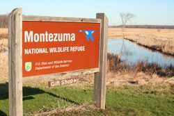 |
May 1973 | Seneca Falls 42°58′N 76°44′W / 42.97°N 76.74°W | A 7,000 acre (28 km²) wildlife preserve containing one of the best examples of undisturbed swamp woodlands in New York or New England. It is a major stop for migratory birds. | |
| 19 | Moss Island |  |
May 1976 | Little Falls 43°02′23″N 74°50′54″W / 43.039771°N 74.848244°W | An igneous intrusion in the Erie Canal with the Little Falls at one end. It became an island when locks were built so boats could avoid the 40 ft (12 m) falls. It is known for its extremely large (40–50 ft) glacial potholes created by retreating glaciers as well as being popular with local rock climbers. | |
| 20 | Moss Lake Bogs | May 1973 | Houghton 42°23′55″N 78°11′05″W / 42.398599°N 78.184687°W | An 83-acre (340,000 m2) glacial kettle lake which filled with melt water and rain. Over time, sphagnum moss has grown over the open water, turning it into an acidic bog. It is managed by the Nature Conservancy. | ||
| 21 | Oak Orchard Creek Marsh | May 1973 | Medina 43°08′06″N 78°22′15″W / 43.135003°N 78.370886°W | The marsh contains a state reserve, Oak Orchard Wildlife Management Area, and a national reserve, the Iroquois National Wildlife Refuge, both of which are known as major stopover points for migratory birds. It was created by a partial blockage of the Oak Orchard River by glacial drift and an outcrop of limestone and dolostone known as the Lockport formation which forms the Niagara Escarpment. | ||
| 22 | Palisades of the Hudson | 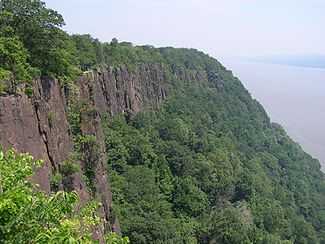 |
November 1984 | Hudson River 40°57′52″N 73°54′31″W / 40.964507°N 73.908591°W | The line of dramatic 350-foot (110 m) cliffs of the Palisades Sill along the west side of the lower Hudson River | |
| 23 | Petrified Gardens |  |
April 1967 | Saratoga Springs 43°04′59″N 73°50′40″W / 43.083047°N 73.844489°W | This private park preserves an area of ancient stromatolites in a fossilized ancient Cambrian reef. Stromatolites "were first recognized, discovered, and interpreted in North America" here in 1922. The park, which is now closed, was a childhood inspiration for Stephen Jay Gould. | |
| 24 | Round Lake | _-_Fayetteville_NY.jpg) |
May 1973 | Fayetteville 43°02′56″N 75°58′23″W / 43.049°N 75.973°W | Part of Green Lakes State Park, this lake is a rare meromictic lake is surrounded by a well preserved mesophytic forest | |
| 25 | Thompson Pond |  |
May 1973 | Pine Plains 41°57′40″N 73°40′43″W / 41.961118°N 73.678737°W | A 75-acre (300,000 m2) glacial kettle pond and surrounding 507-acre (2.05 km2) nature preserve managed by the Nature Conservancy. It is the source of Wappinger Creek, a tributary of the Hudson River that drains much of Dutchess County.. It is known for its calcareous bog, unlike other acidic bogs in the Northeast. | |
| 26 | Zurich Bog |  |
May 1973 | Arcadia 43°08′41″N 77°03′02″W / 43.144648°N 77.050467°W | Wayne County, New York | A sphagnum bog managed by the Bergen Swamp Preservation Society |