List of Historic Sites of Japan (Hokkaido)
This list is of the Historic Sites of Japan located within the Circuit of Hokkaidō.[1]
National Historic Sites
As of 1 July 2014, fifty-two sites have been designated as being of national significance (including one *Special Historic Site).[2][3][4][5]
| Site | Municipality | Comments | Image | Coordinates | Type | Ref. |
|---|---|---|---|---|---|---|
| Usakumai Sites ウサクマイ遺跡群 Usakumai iseki-gun |
Chitose | 42°49′06″N 141°34′31″E / 42.81837213°N 141.57521006°E | 2 | 58 | ||
| Otafunbe Chashi Site オタフンベチャシ跡 Otafunbe chashi ato |
Urahoro | Ainu hilltop fort or chashi; the name is derived from the Ainu terms for "sand" (ota) and "whale" (funbe)[6] | 42°49′32″N 143°50′34″E / 42.82542292°N 143.8428036°E | 2 | 61 | |
| Karinba Site カリンバ遺跡 Karinba iseki |
Eniwa | 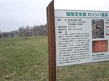 |
42°53′19″N 141°35′41″E / 42.88870998°N 141.59483917°E | 1 | 3413 | |
| Kiusu Burial Mounds キウス周堤墓群 Kiusu shūtei bogun |
Chitose | 42°53′09″N 141°42′59″E / 42.88578385°N 141.71640587°E | 1 | 60 | ||
| Shibechari River Basin Chashi Sites - Appetsu Chashi Site シベチャリ川流域チャシ跡群及びアッペツチャシ跡 Shibechari-gawa ryūiki chashi ato-gun oyobi Appetsu chashi ato |
Shinhidaka, Hidaka | 42°19′46″N 142°22′21″E / 42.32935358°N 142.37250173°E | 2 | 3204 | ||
| Pirika Site ピリカ遺跡 Pirika iseki |
Imakane | 42°28′36″N 140°12′17″E / 42.47658785°N 140.20462821°E | 1 | 75 | ||
| Fugoppe Cave フゴッペ洞窟 Fugoppe dōkutsu |
Yoichi | Zoku-Jōmon rock art: incised human figures, animals, and boats; excavated artefacts include earthenware and items made of stone, horn, and bone[7][8][9] | 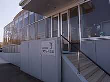 |
43°11′41″N 140°50′17″E / 43.19480151°N 140.83818127°E | 1 | 35 |
| Moshiriya Chashi Site モシリヤ砦跡 Moshiriya chashi ato |
Kushiro | 42°59′01″N 144°23′46″E / 42.98359641°N 144.39600128°E | 1,2 | 18 | ||
| Yukuepira Chashi Site ユクエピラチャシ跡 Yukuepira chashi ato |
Rikubetsu | 43°27′51″N 143°44′09″E / 43.46413265°N 143.73574912°E | 2 | 70 | ||
| Otoe Stone Circle 音江環状列石 Otoe kanjō-resseki |
Fukagawa | 43°40′27″N 142°02′00″E / 43.67411004°N 142.03334165°E | 1 | 36 | ||
| Former Hokkaidō Government Office 開拓使札幌本庁本庁舎跡および旧北海道庁本庁舎 Kaitakushi Sapporo honchō honchōsha ato oyobi kyū-Hokkaidō-chō honchōsha |
Sapporo | 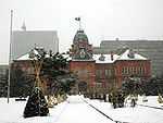 |
43°03′50″N 141°20′54″E / 43.06400008°N 141.34840509°E | 2 | 41 | |
| Kakinoshima Site 垣ノ島遺跡 Kakinoshima iseki |
Hakodate | 41°55′44″N 140°56′51″E / 41.92881355°N 140.94750411°E | 1 | 00003697 | ||
| Former Okuyuki Station Facilities 旧奥行臼駅逓所 kyū-Okuyuki-eki teisho |
Betsukai | 43°18′47″N 145°12′34″E / 43.31302103°N 145.20947525°E | 6 | 00003717 | ||
| Former Lower Yoichi Duty House 旧下ヨイチ運上家 kyū-Shimo-Yoichi unjō-ke |
Yoichi | the ICP Matsumae Clan building of 1853 was renovated in 1891[10] | 43°11′52″N 140°47′18″E / 43.19786188°N 140.78821805°E | 6 | 47 | |
| Former Shimamatsu Station Facilities 旧奥行臼駅逓所 kyū-Shimamatsu-eki teisho |
Kitahiroshima | |
42°55′26″N 141°32′17″E / 42.92398022°N 141.53803619°E | 6 | 68 | |
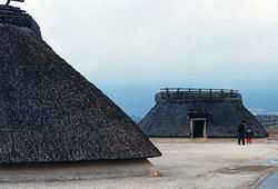
| Former Yoichi Fukuhara Fishery 旧余市福原漁場 kyū-Yoichi Fukuhara gyoba |
Yoichi | herring fishing facilities | 43°11′59″N 140°46′42″E / 43.19972159°N 140.778317°E | 6 | 63 | |
| Former Rumoi Saga Family Fishery 旧留萌佐賀家漁場 kyū-Rumoi Saga-ke gyoba |
Rumoi | 43°54′49″N 141°37′03″E / 43.91366758°N 141.61751178°E | 6 | 77 | ||
| Kotoni Tondenhei Residence 琴似屯田兵村兵屋跡 Kotoni tondenhei-son heioku ato |
Sapporo | the tondenhei (屯田兵) were former samurai recruited from 1874 as farmer-soldiers, to farm and potentially defend Hokkaidō[11] | 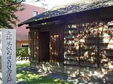 |
43°54′49″N 141°37′03″E / 43.91366758°N 141.61751178°E | 2,6 | 64 |
| Katsuragaoka Chashi Site 桂ヶ岡砦跡 Katsuragaoka chashi ato |
Abashiri | 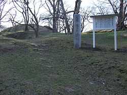 |
44°01′04″N 144°16′12″E / 44.01789442°N 144.26997445°E | 1,2 | 20 | |
| Goryōkaku Site 五稜郭跡 Goryōkaku ato |
Hakodate |  |
41°47′49″N 140°45′25″E / 41.79688684°N 140.75682682°E | 2 | 7 | |
| Ebetsu Kofun Cluster 江別古墳群 Ebetsu kofun-gun |
Ebetsu | 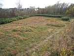 |
43°07′01″N 141°30′57″E / 43.11687899°N 141.51587387°E | 1 | 3205 | |
| Kokutai-ji Site 国泰寺跡 Kokutaiji ato |
Akkeshi | 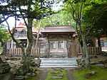 |
43°01′50″N 144°50′15″E / 43.03062071°N 144.83746036°E | 3 | 48 | |
| Nemuro Peninsula Chashi Sites 根室半島チャシ跡群 Nemuro hantō chashi ato-gun |
Nemuro | 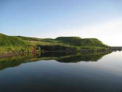 |
43°10′14″N 145°30′24″E / 43.170601°N 145.50654468°E | 2 | 66 | |
| Moyoro Shell Mound 最寄貝塚 Moyoro kaizuka |
Abashiri | 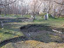 |
44°01′31″N 144°16′05″E / 44.0251911°N 144.26806929°E | 1 | 22 | |
| Shiryōkaku 四稜郭 Shiryōkaku |
Hakodate | 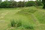 |
41°49′33″N 140°46′13″E / 41.82570421°N 140.77036763°E | 2 | 14 | |
| Shinori Fortified Residence Site 志苔館跡 Shinori tate ato |
Hakodate | destroyed in the Ainu uprisings of 1456 (the Koshamine Uprising (コシャマインの戦い)) and 1512[12] | 41°45′56″N 140°49′20″E / 41.76564477°N 140.82228894°E | 2 | 16 | |
| Temiya Cave 手宮洞窟 Temiya dōkutsu |
Otaru | incised rock art site published by John Milne in the Transactions of the Asiatic Society of Japan in 1879[9] | 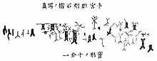 |
43°12′45″N 141°00′13″E / 43.21250491°N 141.00347991°E | 1 | 1 |
| Harutoridaichi Pit Dwellings 春採台地竪穴群 Harutoridaichi tateana-gun |
Kushiro | 42°58′29″N 144°23′58″E / 42.9746889°N 144.39934378°E | 1 | 21 | ||
| Shōnai Han Hamamasu Jin'ya Site 庄内藩ハママシケ陣屋跡 Shōnai-han Hamamashike jinya ato |
Ishikari | 43°35′24″N 141°23′36″E / 43.59010579°N 141.39327093°E | 2 | 73 | ||
| Matsumae Clan Castle Sites 松前氏城跡 Matsumae-shi shiro ato |
Matsumae, Assabu | designation includes the sites of Matsumae Castle (福山城跡) and Tate Castle (館城跡) | 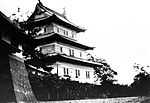 |
41°25′48″N 140°06′29″E / 41.43008755°N 140.1079181°E | 2 | 17 |
| Matsumae Han Hekirichi Jin'ya Site 松前藩戸切地陣屋跡 Matsumae-han Hekirichi jinya ato |
Hokuto | 41°51′14″N 140°37′09″E / 41.85388046°N 140.61915976°E | 2 | 38 | ||
| Matsumae Han Matsumae Clan Graves 松前藩主松前家墓所 Matsumae-han-shu Matsumae-ke bosho |
Matsumae | 41°25′53″N 140°06′21″E / 41.43127597°N 140.10592222°E | 7 | 62 | ||
| Kaminokuni Fortified Residence Sites 上之国館跡 Kaminokuni tate ato |
Kaminokuni | designation includes the sites of the Hanazawa (花沢館跡), Suzagi (洲崎館跡), and Katsuyama (勝山館跡) fortified residences | 41°48′00″N 140°06′02″E / 41.8001294°N 140.10061858°E | 2 | 54 | |
| Tokoro Site 常呂遺跡 Tokoro iseki |
Kitami | 44°07′48″N 144°00′56″E / 44.12991699°N 144.01562941°E | 1 | 49 | ||
| Nishitsukigaoka Site 西月ヶ岡遺跡 Nishitsukigaoka iseki |
Nemuro | 43°18′59″N 145°33′31″E / 43.31649942°N 145.5586636°E | 1 | 52 | ||
| Shizugawa Site 静川遺跡 Shizugawa iseki |
Tomakomai | 42°40′37″N 141°49′06″E / 42.6770498°N 141.8184439°E | 1 | 69 | ||
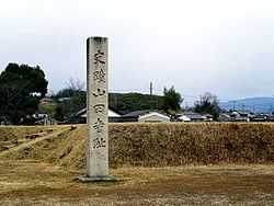
| Zenkō-ji Site 善光寺跡 Zenkōji ato |
Date | 42°31′15″N 140°46′48″E / 42.52080711°N 140.77993451°E | 3 | 50 | ||
| Ō Fortified Residence Site 大館跡 Ō tate ato |
Matsumae | 41°26′10″N 140°06′32″E / 41.43601967°N 140.10886886°E | 2 | 53 | ||
| Ōfune Site 大船遺跡 Ōfune iseki |
Hakodate | submitted for inscription on the UNESCO World Heritage List as one of the Jōmon Archaeological Sites in Hokkaidō, Northern Tōhoku, and other regions[13][4] | 41°57′29″N 140°55′27″E / 41.95794955°N 140.9243044°E | 1 | 3300 | |
| Ōyachi Shell Mound 大谷地貝塚 Ōyachi kaizuka |
Yoichi | 43°11′27″N 140°50′07″E / 43.19088619°N 140.83530442°E | 1 | 3270 | ||
| Tsurugataicharanke Chashi Site 鶴ヶ岱チャランケ砦跡 Tsurugataicharanke chashi ato |
Kushiro | 42°58′40″N 144°24′31″E / 42.9778849°N 144.40859967°E | 1, 2 | 19 | ||
| East Ezo Nanbu Han Jin'ya Sites 東蝦夷地南部藩陣屋跡 higashi Ezo-chi Nanbu-han jinya ato |
Muroran, Oshamambe, Mori | designation includes the sites of the Mororan Jin'ya (モロラン陣屋跡), Oshamanbe Jin'ya (ヲシャマンベ陣屋跡), and Sunahara Jin'ya (砂原陣屋跡) | 42°22′11″N 140°56′53″E / 42.36970568°N 140.94814432°E | 2 | 15 | |
| East Kushiro Shell Mound 東釧路貝塚 higashi Kushiro kaizuka |
Kushiro | 42°59′39″N 144°24′45″E / 42.99405818°N 144.41248976°E | 1 | 42 | ||
| Irie-Takasago Shell Mound 入江・高砂貝塚 Irie-Takasago kaizuka |
Tōyako | submitted for inscription on the UNESCO World Heritage List as one of the Jōmon Archaeological Sites in Hokkaidō, Northern Tōhoku, and other regions[13][4] | 42°32′50″N 140°46′13″E / 42.54710056°N 140.77019889°E | 1 | 3333 | |
| Oshoro Stone Circle 忍路環状列石 Oshoro kanjō-resseki |
Otaru | 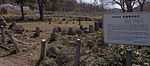 |
43°11′58″N 140°52′29″E / 43.199579°N 140.87464787°E | 1 | 37 | |
| Shirataki Site 白滝遺跡群 Shirataki iseki |
Engaru | 43°52′28″N 143°08′00″E / 43.8743758°N 143.13345593°E | 1 | 74 | ||
| Shiraoi Sendai Han Jin'ya Site 白老仙台藩陣屋跡 Shiraoi Sendai-han jinya ato |
Shiraoi | 42°33′47″N 141°20′34″E / 42.56317149°N 141.34291527°E | 2 | 39 | ||
| Shibetsu Sites 標津遺跡群 Shibetsu iseki-gun |
Shibetsu | designation includes the Ichanikarikariusu Site (伊茶仁カリカリウス遺跡), old road, and Sanbongi Site (三本木遺跡) | 43°40′28″N 145°05′39″E / 43.67438382°N 145.0941493°E | 1 | 51 | |
| Kitakogane Shell Mound 北黄金貝塚 Kitakogane kaizuka |
Date | submitted for inscription on the UNESCO World Heritage List as one of the Jōmon Archaeological Sites in Hokkaidō, Northern Tōhoku, and other regions[13][4] | 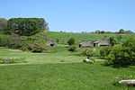 |
42°24′07″N 140°54′38″E / 42.40203392°N 140.91064837°E | 1 | 71 |
| Hokuto Site 北斗遺跡 Hokuto iseki |
Kushiro | 43°04′07″N 144°19′02″E / 43.06873613°N 144.31718424°E | 1 | 56 | ||
| Mobetsu Fortified Residence Site 茂別館跡 Mobetsu tate ato |
Hokuto | 41°46′13″N 140°36′15″E / 41.77022042°N 140.60413071°E | 2 | 65 | ||
| Washinoki Site 鷲ノ木遺跡 Washinoki iseki |
Mori | submitted for inscription on the UNESCO World Heritage List as one of the Jōmon Archaeological Sites in Hokkaidō, Northern Tōhoku, and other regions[13][4] | 42°06′58″N 140°31′34″E / 42.11602639°N 140.52606523°E | 1 | 00003466 |
Prefectural Historic Sites
As of 1 May 2014, twenty-six sites have been designated as being of prefectural importance.[4][14][15]
| Site | Municipality | Comments | Image | Coordinates | Type | Ref. |
|---|---|---|---|---|---|---|
| Kobui Blast Furnace Site 古武井熔鉱炉跡 Kobui yōkōro ato | Hakodate | 41°47′38″N 141°05′56″E / 41.793816°N 141.098775°E | ||||
| Menagawa Brick Mill Site 女那川煉瓦製造所跡 Menagawa renga seizōjo ato | Hakodate | 41°45′44″N 141°04′31″E / 41.762349°N 141.075225°E | ||||
| Esan Shell Mound 恵山貝塚 Esan kaizuka | Hakodate | 41°47′37″N 141°09′12″E / 41.793688°N 141.153288°E | ||||
| Ippongi Triangulation Base 開拓史三角測量一本木基点 kaitaku-shi sankaku-sokuryō-Ippongi kiten | Hokuto | 41°50′10″N 140°39′43″E / 41.836124°N 140.661950°E | ||||
| Aonae Dune Site 青苗砂丘遺跡 Aonae sakyū iseki | Okushiri | 42°03′56″N 139°27′10″E / 42.065575°N 139.452703°E | ||||
| Iwanai Higashiyama Cylinder Culture Site 岩内東山円筒文化遺跡 Iwanai Higashiyama entō bunka iseki | Iwanai | 42°59′00″N 140°31′34″E / 42.983381°N 140.526145°E | ||||
| Mount Jichin Stone Circle 地鎮山環状列石 Jichin-yama kanjō-resseki | Otaru | 43°11′49″N 140°52′18″E / 43.197026°N 140.871538°E | ||||
| Mount Nishizaki Stone Circle 西崎山環状列石 Nishizaki-yama kanjō-resseki | Yoichi | 43°11′24″N 140°50′46″E / 43.190030°N 140.846046°E | ||||
| Nokanan Burial Mounds 野花南周堤墓群 Nokanan shūtei bogun | Ashibetsu | 43°28′08″N 142°16′06″E / 43.468992°N 142.268357°E | ||||
| Kamui Kotan Pit Dwelling Site 神居古潭竪穴住居遺跡 Kamui Kotan tateana jūkyo iseki | Asahikawa | 43°43′31″N 142°11′14″E / 43.725336°N 142.187119°E | ||||
| Gokoku-ji Site 宗谷の護国寺跡 Sōya Gokokuji ato | Wakkanai | 45°29′06″N 141°53′01″E / 45.485049°N 141.883492°E | ||||
| Hamatonbetsu Lake Kutcharo Pit Group 浜頓別クッチャロ湖畔竪穴群 Hamatonbetsu Kutcharo-ko hotori tateana-gun | Hamatonbetsu | 45°07′31″N 142°20′50″E / 45.125231°N 142.347150°E | ||||
| Okoppe Toyono Pit Dwelling Site 興部豊野竪穴住居跡 Okoppe Toyono tateana jūkyo ato | Okoppe | 44°27′35″N 143°10′02″E / 44.459860°N 143.167123°E | ||||
| Shari Burial Mounds 斜里朱円周堤墓群 Shari shuen shūtei bogun | Shari | 43°54′45″N 144°40′03″E / 43.912533°N 144.667593°E | ||||
| Shari Pit Dwelling Sites 朱円竪穴住居跡群 shuen tateana jūkyo ato-gun | Shari | 43°55′01″N 144°45′23″E / 43.916938°N 144.756289°E | ||||
| Omusaro Plateau Pit Group オムサロ台地竪穴群 Omusaro daichi tateana-gun | Monbetsu | 44°23′23″N 143°16′57″E / 44.389697°N 143.282404°E | ||||
| Shibunotsunai Pit Dwelling Site シブノツナイ竪穴住居跡 Shibunotsunai tateana jūkyo ato | Yūbetsu | 44°14′43″N 143°33′45″E / 44.245199°N 143.562384°E | ||||
| Yūfutsu Triangulation Base 開拓使三角測量勇払基点 kaitaku-shi sankaku-sokuryō Yūfutsu-kiten | Tomakomai | 42°37′55″N 141°43′54″E / 42.632001°N 141.731744°E | ||||
| Mukawa Tomb Cluster 鵡川盛土墳墓群 Mukawa moritsuchi funbo-gun | Mukawa | 42°33′45″N 141°56′32″E / 42.562611°N 141.942319°E | ||||
| Shizunai Mount Goten Tomb Cluster 静内御殿山墳墓群 Shizunai Goten-yama funbo-gun | Shinhidaka | 42°22′09″N 142°23′37″E / 42.369222°N 142.393595°E | ||||
| Monbetsu Tomihito Family Graves 門別富仁家噴墓群 Monbetsu Tomihito-ke funbo-gun | Hidaka | 42°28′48″N 142°04′24″E / 42.479915°N 142.073339°E | ||||
| Urahoro Shinyoshino Plateau Stone Tool Site 浦幌新吉野台細石器遺跡 Urahoro Shinyoshino-dai hoso-sekki iseki | Urahoro | 42°46′07″N 143°37′24″E / 42.768628°N 143.623281°E | ||||
| Tokachi Okoppe Site 十勝オコッペ遺跡 Tokachi Okoppe iseki | Urahoro | 42°47′04″N 143°47′13″E / 42.784441°N 143.787003°E | ||||
| Tokachi Buto Sites 十勝太遺跡群 Tokachi Buto iseki-gun | Urahoro | 42°45′40″N 143°41′08″E / 42.761035°N 143.685594°E | ||||
| Tokachi Horokayantō Pit Group 十勝ホロカヤントー竪穴群 Tokachi Horokayantō tateana-gun | Taiki | 42°32′40″N 143°29′26″E / 42.544544°N 143.490672°E | ||||
| Akkeshi Kamuiwa Chashi and Pit Group 厚岸神岩砦跡及び竪穴群 Akkeshi Kamuiwa chashi ato oyobi tateana-gun | Akkeshi | 43°04′09″N 144°52′57″E / 43.069139°N 144.882631°E | ||||
Municipal Historic Sites
As of 1 May 2014, a further one hundred and seventy-nine sites have been designated as being of municipal importance.[16][17][18]
| |||||||||||||||||||||||||||||||||||||||||||||
See also
- Cultural Properties of Japan
- List of Places of Scenic Beauty of Japan (Hokkaidō)
- List of Cultural Properties of Japan - paintings (Hokkaidō)
References
| Wikimedia Commons has media related to National historic sites in Hokkaido prefecture. |
- ↑ "Cultural Properties for Future Generations". Agency for Cultural Affairs. Retrieved 30 July 2014.
- ↑ 史跡名勝天然記念物 [Number of Monuments of Japan by Prefecture] (in Japanese). Agency for Cultural Affairs. 1 July 2014. Retrieved 30 July 2014.
- ↑ "Database of National Cultural Properties: 史跡名勝天然記念物 (史跡, 特別史跡 北海道)" (in Japanese). Agency for Cultural Affairs. Retrieved 30 July 2014.
- ↑ 4.0 4.1 4.2 4.3 4.4 4.5 道内の指定文化財件数一覧 [Number of Cultural Properties of Hokkaidō] (in Japanese). Hokkaidō. 31 March 2014. Retrieved 30 July 2014.
- ↑ 国の指定・選定文化財一覧 [List of National Cultural Properties of Hokkaidō] (in Japanese). Hokkaidō. Retrieved 30 July 2014.
- ↑ オタフンベチャシ跡 [Otafunbe Chashi Site] (in Japanese). Urahoro Town. Retrieved 21 June 2012.
- ↑ フゴッペ洞窟 [Fugoppe Cave] (in Japanese). Yoichi Town. Retrieved 21 June 2012.
- ↑ フゴッペ洞窟 [Fugoppe Cave] (in Japanese). Agency for Cultural Affairs. Retrieved 21 June 2012.
- ↑ 9.0 9.1 Hudson, Mark (17 August 2003). "Japan's Cave Art: Mystery cloaks Hokkaido motifs". The Japan Times. Retrieved 21 June 2012.
- ↑ 旧下ヨイチ運上家 [Former Lower Yoichi Duty House] (in Japanese). Agency for Cultural Affairs. Retrieved 21 June 2012.
- ↑ Irish, Ann B (2009). Hokkaido: A History of Ethnic Transition and Development on Japan's Northern Island. McFarland. pp. 119 ff. ISBN 978-0-786-44449-6.
- ↑ 志苔館跡 [Shinori Fortified Residence Site] (in Japanese). Hakodate City. Retrieved 21 June 2012.
- ↑ 13.0 13.1 13.2 13.3 "Jômon Archaeological Sites in Hokkaidô, Northern Tôhoku, and other regions". UNESCO. Retrieved 22 June 2012.
- ↑ 都道府県別指定等文化財件数(都道府県分) [Number of Prefectural Cultural Properties by Prefecture] (in Japanese). Agency for Cultural Affairs. 1 May 2014. Retrieved 30 July 2014.
- ↑ 北海道指定の文化財一覧 [List of Prefectural Cultural Properties of Hokkaidō] (in Japanese). Hokkaidō. Retrieved 30 July 2014.
- ↑ 都道府県別指定等文化財件数(市町村分) [Number of Municipal Cultural Properties by Prefecture] (in Japanese). Agency for Cultural Affairs. 1 May 2014. Retrieved 30 July 2014.
- ↑ 市町村指定文化財の総括表(平成24年4月1日現在) [Number of Municipal Cultural Properties by Municipality] (in Japanese). Hokkaidō. 1 April 2012. Retrieved 30 July 2014.
- ↑ 市町村指定文化財一覧 [List of Municipal Cultural Properties of Hokkaidō] (in Japanese). Hokkaidō. 1 April 2012. Retrieved 30 July 2014.
External links
- (Japanese) Cultural Properties of Hokkaidō
- (Japanese) List of National Cultural Properties of Hokkaidō
- (Japanese) List of Prefectural Cultural Properties of Hokkaidō
- (Japanese) List of Municipal Cultural Properties of Hokkaidō