List of Cultural Properties of Japan - historical materials (Kyōto)
This list is of the Cultural Properties of Japan designated in the category of historical materials (歴史資料 rekishi shiryō) for the Urban Prefecture of Kyoto.[1]
National Cultural Properties
As of 1 December 2014, twenty Important Cultural Properties have been designated, being of national significance.[2][3]
| Property | Date | Municipality | Ownership | Comments | Image | Coordinates | Ref. |
|---|---|---|---|---|---|---|---|
| Architectural Drawings of Josiah Conder ジョサイア・コンドル建築図面 Josaia Kondoru kenchiku zumen | Meiji to Taishō period | Kyoto | Kyoto University | 468 items |  | 35°01′39″N 135°46′46″E / 35.02736125°N 135.77930834°E | |
| No. 123 Locomotive 一二三号機関車</一八七三年、英国製> hyaku-nijū-san-gō kikansha | 1873 | Yosano | Kaya Kosan Company Ltd (kept at Kaya Steam Locomotive Square (加悦SL広場) | made in England | 35°28′51″N 135°05′34″E / 35.48092898°N 135.0927277°E | ||
| Port Dues Banner and Documents of the Hata Family 過所船旗〈文永九年二月日/(麻布)〉 秦家文書 Kasho senki Hata-ke monsho | Kamakura to Edo period | Kyoto | Kyoto University (kept at The Kyoto University Museum (京都大学総合博物館)) | 109 items | 35°01′38″N 135°46′45″E / 35.02709376°N 135.77910505°E | ||
| Materials relating to Iwakura Tomomi 岩倉具視関係資料 Iwakura Tomomi kankei shiryō | C19 | Kyoto | Kyoto City History Museum | 1,018 items | 35°04′42″N 135°46′59″E / 35.078441°N 135.783126°E | ||
| Administrative Documents of Kyoto Prefecture 京都府行政文書 Kyōto-fu gyōsei bunsho | Edo to Shōwa period | Kyoto | Kyoto Prefectural Library and Archives (京都府立総合資料館) | 15,407 items | 35°03′03″N 135°45′58″E / 35.05075107°N 135.76603253°E | ||
| Materials relating to Sakamoto Ryōma 坂本龍馬関係資料 Sakamoto Ryōma kankei shiryō | C19 | Kyoto | Kyoto National Museum | 10 items | 34°59′24″N 135°46′25″E / 34.98995551°N 135.77351413°E | ||
| Sangaku 算額〈元禄四年五月二十四日長谷川鄰完奉納/〉 sangaku | 1691 | Kyoto | Yasaka Jinja | 35°00′13″N 135°46′43″E / 35.003627°N 135.778527°E | |||
| Shinju-an Masu 真珠庵枡 Shinjuan masu | Muromachi period | Kyoto | Shinju-an (真珠庵) | 2 items | 35°02′40″N 135°44′47″E / 35.044333°N 135.746405°E | ||
| Joseon Diplomatic Documents 朝鮮国書 Chōsen tsūshinshi kankei shiryō | 1607-17 | Kyoto | Kyoto University (kept at The Kyoto University Museum (京都大学総合博物館)) | 3 items | 35°01′39″N 135°46′45″E / 35.02736203°N 135.77930333°E | ||
| Materials relating to the Joseon Missions 朝鮮通信使関係資料 Chōsen tsūshinshi kankei shiryō | Edo period | Kyoto | Yūrinkan Museum (藤井斉成会有鄰館) | 9 items | 35°00′42″N 135°46′53″E / 35.011708°N 135.781260°E | ||
| Tetsugen Edition Sutra Woodblocks 鉄眼版一切経版木 Tetusgen-ban issaikyō hangi | Edo period | Uji | Hōzō-in (宝蔵院) | 48,275 items | 34°54′55″N 135°48′16″E / 34.915391°N 135.804491°E | ||
| Nanzen-ji Temple Instructions 南禅寺仏殿指図(三図) Nanzenji sashizu | Muromachi period | Kyoto | Nanzen-ji | 35°00′40″N 135°47′38″E / 35.011185°N 135.793805°E | |||
| Map of Japan 日本図 Nihon-zu | 1305 | Kyoto | Ninna-ji | .jpg) | 35°01′52″N 135°42′50″E / 35.031007°N 135.713811°E | ||
| Materials relating to the Yase Dōji 八瀬童子関係資料 Yase Dōji kankei shiryō | Muromachi period onwards | Kyoto | Kyoto City History Museum | 741 items | 35°01′09″N 135°46′04″E / 35.01912984°N 135.76783136°E | ||
| Ceremonial Fans of the Mibu Family 桧扇(壬生家伝来) Hiōgi (Mibu-ke denrai) | Kamakura to Muromachi period | Kyoto | Kyoto University (kept at The Kyoto University Museum (京都大学総合博物館)) | two fans | 35°01′38″N 135°46′45″E / 35.02709376°N 135.77910505°E | ||
| Fukō-in Temple Instructions 普広院指図 Fukō-in sashizu | Muromachi period | Kyoto | Shōkoku-ji | 35°01′59″N 135°45′44″E / 35.033049°N 135.762171°E | |||
| Buke Shohatto Drafts 武家諸法度草稿〈以心崇伝筆/元和二年十月日〉 Buke shohatto sōkō | 1616 | Kyoto | Konchi-in (金地院) | one scroll in the hand of Ishin Sūden | 35°00′37″N 135°47′26″E / 35.010227°N 135.790447°E | ||
| Fushimi-ban Woodcut Characters 伏見版木活字 Fushimi-ban moku-katsuji | Edo period | Kyoto | Enkō-ji | 52,320 items | 35°02′42″N 135°47′49″E / 35.045053°N 135.797077°E | ||
| Materials relating to the Fukui Family Kyoto Masu Guild 福井家京枡座関係資料 Fukui-ke Kyō-masuza kankei shiryō | Edo period | Kyoto | 2,139 items | ||||
Prefectural Cultural Properties
As of 1 December 2014, thirteen properties have been designated at a prefectural level.[4]
| Property | Date | Municipality | Ownership | Comments | Image | Coordinates | Ref. |
|---|---|---|---|---|---|---|---|
| Materials relating to the Kyōto Institution for the Blind 京都盲啞院関係資料 Kyōto mōai-in kankei shiryō | Edo to Taishō period | Kyoto | Kyoto Prefecture | 732 items | 35°01′16″N 135°45′20″E / 35.020995°N 135.755605°E | ||
| Materials relating to the Minagawa Family Tenmon Rekidō 皆川家天文暦道関係資料 Minagawa-ke Tenmon Rekidō kankei shiryō | Muromachi to Meiji period | Kyoto | Daishōgunhachi Jinja (大将軍八神社) | 498 items | 35°01′36″N 135°44′02″E / 35.026640°N 135.733970°E | ||
| Materials relating to Taichū Shōnin 袋中上人関係資料 Taichū Shōnin kankei shiryō | Momoyama to Edo period | Kyoto | Dannōhōrin-ji (檀王法林寺) |  | 35°00′36″N 135°46′24″E / 35.009867°N 135.773227°E | ||
| Chinkō-ji Sankei Mandala 珍皇寺参詣曼荼羅 Chinkōji sankei mandara | Momoyama period | Kyoto | Rokudō Chinkō-ji (六道珍皇寺) | sankei mandala (参詣曼荼羅) depict the sacred sites of shrines and temples, populated with pilgrims and related historical and legendary events, and were often used in explanatory story-telling or e-toki[5] |  | 34°59′54″N 135°46′31″E / 34.998403°N 135.775357°E | |
| Kiyomizu-dera Sankei Mandala 清水寺参詣曼荼羅 Kiyomizudera sankei mandara | Muromachi period | Kyoto | Kiyomizu-dera |  | 34°59′41″N 135°47′06″E / 34.994804°N 135.785018°E | ||
| Hōrin-ji Sankei Mandala 法輪寺参詣曼荼羅 Hōrinji sankei mandara | Momoyama period | Kyoto | Hōrin-ji |  | 35°00′37″N 135°40′37″E / 35.010205°N 135.677000°E | ||
| Yoshimine-dera - Sankō-ji Sankei Mandala 善峰寺参詣曼荼羅・三鈷寺参詣曼荼羅 Yoshimine-dera・Sankōji sankei mandara | Muromachi period | Kyoto | Yoshimine-dera | | 34°56′16″N 135°38′39″E / 34.937874°N 135.644159°E | ||
| Hikioi Mandala Woodblocks 曳覆曼荼羅版木 Hikioi mandala hangi | 1375 | Kizugawa | Saimyō-ji (西明寺) | 2 items | 34°45′03″N 135°51′23″E / 34.750917°N 135.856338°E | ||
| Materials relating to Tokuhō Zenketsu 特芳禅傑関係資料 Tokuhō Zenketsu kankei shiryō | Muromachi to Edo period | Kameoka | Ryōtan-ji (龍潭寺) | 21 items | 35°01′37″N 135°32′30″E / 35.027018°N 135.541688°E | ||
| Historical Materials relating to Isshi Bunshu at Hōjōji 法常寺一絲文守他歴代関係資料 Hōjōji Isshi Bunshu hoka rekidai kankei shiryō | Edo period | Kameoka | Hōjō-ji (法常寺) | 337 items | 35°00′54″N 135°26′39″E / 35.015086°N 135.444270°E | ||
| Nariai-ji Sankei Mandala 成相寺参詣曼荼羅 Nariaiji sankei mandara | Muromachi period | Miyazu | Nariai-ji (成相寺) | 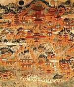 | 35°35′44″N 135°11′15″E / 35.595536°N 135.187443°E | ||
| Materials relating to Genpō Reizan 玄圃霊三関係資料 Genpō Reizan kankei shiryō | Momoyama to Edo period | Kyōtango | Sōun-ji (宗雲寺) | 36 items | .jpg) | 35°36′07″N 134°53′11″E / 35.601961°N 134.886516°E | |
| Historical Records of the Kameyama Domain 亀山藩史料 Kameyama-han shiryō | Edo to Meiji period | Kameoka | Kameoka City Bunka Shiryōkan (亀岡市文化資料館) | 198 items | 35°00′49″N 135°35′08″E / 35.013522°N 135.585526°E | ||
Registered Cultural Properties
In addition, as of 1 December 2014 one property has been registered (as opposed to designated) nationally and another at the prefectural level:
| Property | Date | Municipality | Ownership | Comments | Image | Coordinates | Ref. |
|---|---|---|---|---|---|---|---|
| Materials for Architectural Education 建築教育資料(京都帝国大学工学部建築学教室旧蔵) kenchiku kyōiku shiryō | Ancient to Modern | Kyoto | Kyoto University | 2,653 items (national registration) | 35°01′39″N 135°46′46″E / 35.02736125°N 135.77930834°E | ||
| Materials relating to Hatago Matsuya 旅籠松屋関係資料 Hatago Matsuya kankei shiryō | Edo to Meiji period | Kyoto | private | 1,293 items (prefectural registration) | |||
| |||||||||||||||||||||||||||||||||||||||||||||
See also
- Cultural Properties of Japan
- List of National Treasures of Japan (historical materials)
- Kyoto National Museum
References
- ↑ "Pamphlet on Cultural Properties". Agency for Cultural Affairs. Retrieved 30 December 2014.
- ↑ 国宝・重要文化財 [Number of National Treasures and Important Cultural Properties by Prefecture] (in Japanese). Agency for Cultural Affairs. 1 December 2014. Retrieved 30 December 2014.
- ↑ "Database of National Cultural Properties: 国宝・重要文化財(美術品)(歴史資料 京都府)" (in Japanese). Agency for Cultural Affairs. Retrieved 30 December 2014.
- ↑ 歴史資料 [Historical Materials] (in Japanese). Kyoto Prefecture. Retrieved 30 December 2014.
- ↑ "sankei mandara". Japanese Architecture and Art Net Users System. Retrieved 30 December 2014.
External links
- (Japanese) Cultural Properties in Kyoto Prefecture
- (Japanese) Cultural Properties in Kyoto City