Lippetal
| Lippetal | ||
|---|---|---|
|
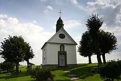
St. Anna chapel in Nordwald | ||
| ||
 Lippetal | ||
Location of Lippetal within Soest district 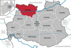
 | ||
| Coordinates: 51°38′59″N 08°04′59″E / 51.64972°N 8.08306°ECoordinates: 51°38′59″N 08°04′59″E / 51.64972°N 8.08306°E | ||
| Country | Germany | |
| State | North Rhine-Westphalia | |
| Admin. region | Arnsberg | |
| District | Soest | |
| Government | ||
| • Mayor | Matthias Lürbke (Ind.) | |
| • Governing parties | CDU | |
| Area | ||
| • Total | 126.58 km2 (48.87 sq mi) | |
| Population (2013-12-31)[1] | ||
| • Total | 11,758 | |
| • Density | 93/km2 (240/sq mi) | |
| Time zone | CET/CEST (UTC+1/+2) | |
| Postal codes | 59510 | |
| Dialling codes |
02923 (Herzfeld) 02527 (Lippborg) | |
| Vehicle registration | SO | |
| Website | www.lippetal.de | |

Lippetal is a municipality in the district of Soest, in North Rhine-Westphalia, Germany.
Geography
Lippetal is located north and south of the river Lippe between the cities of Lippstadt (15 km) and Hamm (10 km). Lippetal is situated at the northern boundary of the Soester Börde, south of the river Lippe and the southern Münsterland in north of the river. The river Lippe flows from east to the west through the municipality.

Division of the municipality
There are eleven villages in Lippetal:
|
|
Neighbouring Places
History
The municipality Lippetal was created by administrative reorganization in 1969. Lippetal was made with eleven villages from three different districts.
The villages are mostly old Saxon settlements. The villages Oestinghausen and Lippborg were first mentioned in 1189, Hovestadt in 1213, and the place of pilgrimage Herzfeld in a document in 786.
References
- ↑ "Amtliche Bevölkerungszahlen". Landesbetrieb Information und Technik NRW (in German). 4 September 2014.
External links
- Official site (German)
| ||||||||