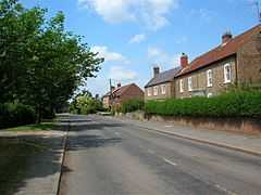
Linton-on-Ouse
| Linton-on-Ouse | |
 Linton on Ouse |
|
 Linton-on-Ouse |
|
| Population | 1,024 |
|---|---|
| OS grid reference | SE493607 |
| Civil parish | Linton-on-Ouse |
| District | Hambleton |
| Shire county | North Yorkshire |
| Region | Yorkshire and the Humber |
| Country | England |
| Sovereign state | United Kingdom |
| Post town | YORK |
| Postcode district | YO30 2 |
| Police | North Yorkshire |
| Fire | North Yorkshire |
| Ambulance | Yorkshire |
| EU Parliament | Yorkshire and the Humber |
| UK Parliament | Thirsk and Malton |
Coordinates: 54°02′26″N 1°14′54″W / 54.0405°N 1.2483°W
Linton-on-Ouse is a village and civil parish in the Hambleton district of North Yorkshire, England, about eight miles north-west of York. It lies on the north bank of the River Ouse.
History
The village is mentioned in the Domesday Book as Luctone in the Bulford hundred. The manor at this time was split between Thorfin of Ravensworth and Thorn of Linton. Afterwards the manor was granted to Robert of Mortain.[1] The manor passed to Thomas de Ros, 4th Baron de Ros in the 14th century and remained in their family until the mid=16th century. At the beginning of the 18th century the manorial rights were sold to University College, Oxford, who built a school in the village in 1871.[2][3]
In the mid-18th century, Acts of Parliament were passed to make the River Ouse navigable. This included the building of a lock at Linton-on-Ouse that is now a Grade II Listed Building.[4]
There used to be a Catholic Chapel in the village between 1700 and 1855.[2]
Since 1937 RAF Linton-on-Ouse has been home to a Royal Air Force station, RAF Linton-on-Ouse. Since 1957 the main role of the airfield has been the training of pilots.[5]
In the summer of 1960 and 1961, the perimeter track of the airfield was used to form the 1.7mile Linton-on-Ouse Motor Racing circuit.[6]
Governance
The village lies within the Thirsk and Malton Parliamentary constituency. It also lies within the Shipton ward of Hambleton District Council and the Stillington electoral division of North Yorkshire County Council.[7]
Geography
The nearest settlements are Newton-on-Ouse 1.2 miles (1.9 km) to the south-east, Aldwark 2.5 miles (4.0 km) to the north-west and Thorpe Underwood 2.1 miles (3.4 km) to the south-west. Sandwath Beck joins Shorn Dike to the north-east of the village before flowing into the River Kyle just to the east of the school.[7]
The 1881 UK Census recorded the population as 296.[2] The 2001 UK Census recorded the population as 1,024, of which 723 were over the age of sixteen years old. There were 388 dwellings, of which 134 were detached.[8]
Public services

Education is provided at Linton-on-Ouse Primary School. The school is within the catchment area of Easingwold School for secondary education.[9]
There is a village store, public house and several local businesses. The village is served by the bus service that runs between York and Easingwold.[10]
Twinning
In 2012 the village started formal twinning procedures with Montcony in France. This is linked to the loss of a Halifax Bomber and crew, stationed here during World War II, in the French village and the respect shown by those villagers to the remains of the crew.[11]
References
- ↑ Linton-upon-Ouse in the Domesday Book. Retrieved 5 January 2013.
- ↑ 2.0 2.1 2.2 Bulmer's Topography, History and Directory (Private and Commercial) of North Yorkshire 1890. S&N Publishing. 1890. pp. 767, 768. ISBN 1-86150-299-0.
- ↑ "History". Retrieved 5 January 2013.
- ↑ "Lock Listing". Retrieved 5 January 2013.
- ↑ RAF Linton-on-Ouse
- ↑ Peter Swinger (2008). Motor Racing Circuits in England : Then & Now. Ian Allan Publishing. ISBN 0 7110 3104 5.
- ↑ 7.0 7.1 Ordnance Survey Open Viewer
- ↑ "2001 UK Census". Retrieved 5 January 2013.
- ↑ "Education". Retrieved 5 January 2013.
- ↑ "Services". Retrieved 5 January 2013.
- ↑ "Local History". Retrieved 5 January 2013.
External links
| Wikimedia Commons has media related to Linton-on-Ouse. |