Linga, Victoria
For other uses, please see Linga (disambiguation)
| Linga Victoria | |||||||||||||
|---|---|---|---|---|---|---|---|---|---|---|---|---|---|
|
Entering Linga | |||||||||||||
 Linga | |||||||||||||
| Coordinates | 35°10′24″S 141°41′33″E / 35.17333°S 141.69250°ECoordinates: 35°10′24″S 141°41′33″E / 35.17333°S 141.69250°E | ||||||||||||
| Population | 98 (2006)[1] | ||||||||||||
| Postcode(s) | 3509 | ||||||||||||
| Elevation | 98 m (322 ft) | ||||||||||||
| Location | |||||||||||||
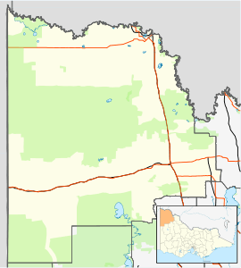
| LGA(s) | Rural City of Mildura | ||||||||||||
| State electorate(s) | Mildura | ||||||||||||
| Federal Division(s) | Mallee | ||||||||||||
| |||||||||||||
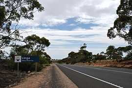
Linga is a locality situated on the section of the Mallee Highway between Ouyen and the South Australian border in the Sunraysia region. The place by road, is situated about 8 kilometres east from Boinka and 11 kilometres west from Underbool.
The name Linga is believed to be an invented derivative from the traditional Aboriginal name Lar-gni which meant camp of ... because as a place to camp it was a place to linger.[3]
The Post Office (as a receiving office) opened on 15 July 1912 when a regular mail service was provided by the opening of the railway from Ouyen to Murrayville a month earlier. It was called Manpy until 1913 and closed in 1975.[4]
References
- ↑ Australian Bureau of Statistics (25 October 2007). "Linga (State Suburb)". 2006 Census QuickStats. Retrieved 2007-10-01.
- ↑ Travelmate
- ↑ Dictionary of Aboriginal Placenames
- ↑ Premier Postal History, Post Office List, retrieved 2008-04-11