Limmatquai Zürich
| <span class="nickname" ">Limmatquai | |
|
Limmatquai | |
| Former name(s) | Sonnenquai; Rathausquai |
|---|---|
| Owner | City of Zürich |
| Length | 1 kilometre (0.6 mi) |
| Addresses | Limmatquai |
| Location |
Bahnhofbrücke–Central–Rathausbrücke–Quaibrücke–Bellevueplatz Zürich, Switzerland |
| Postal code | 8001 |
| Coordinates | 47°22′01″N 8°32′28″E / 47.367°N 8.541°E |
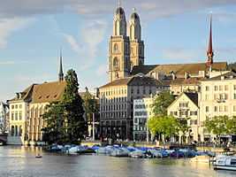
Limmatquai is a pedestrian zone in Zürich, Switzerland. It is named after the Limmat river, and was once one of the nodal points of road and public transportation. Today, Limmatquai is the southern extension of the Seeuferanlage promenades that were built between 1881 and 1887,[1] and one of the best known visitor attractions of the oldest area of the city of Zürich.
Geography
Limmatquai comprises the historical core of the medieval town of Zürich, previously the Celtic-Roman Turicum. It runs along the right-hand (eastern) bank of the Limmat river for about 1 kilometre (0.6 mi), opposite of downstream Stadthausquai, Münsterhof and Münsterbrücke, Wühre, Rathausbrücke and Schipfe alongside the Lindenhof hill. Its southern end is at the Quaibrücke and Bellevueplatz, where the river Limmat leaves the lake (Zürichsee), and the Central plaza marks its northern end. The Rathaus district including the historical Neumarkt and Niederdorf quarters are in the west alongside the Limmatquai.
Points of interest
Grossmünster and Predigern are the ancient parish churches of that part of the medieval river town of Zürich on the right bank, Fraumünster and St. Peter of the left bank, and the Wasserkirche in-between is situated on an former island at today's Limmatquai. Among the numerous buildings from the high Middle Ages are Rüden (Constaffel) and the guild houses Zimmerleuten, Haue (Kämbel), Saffran and Meisen at Münsterhof, also a prominent faience museum, as the most known, and the Rathaus, the seat of the assemblies of the city and of the cantonal parliaments. Limmatquai is one of the main attractions for tourists, and has many small shops, cafés and restaurants. The best-known annual event is the Sechseläuten parade towards Sechseläutenplatz.
-
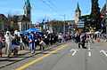
Gesellschaft zu Fraumünster on occasion of Sechseläuten 2013
-
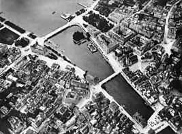
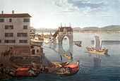
The area of the former Rathausquai and ...
-
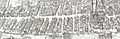
... on the so-called Murerplan map of 1576 and ...
-
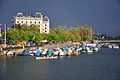
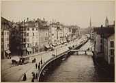
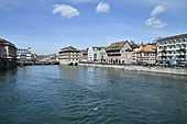
... before a summer storm the Sonnenquai, Bellevueplatz and Quaibrücke, as seen from Münsterbrücke.
-
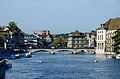
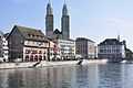
Münsterbrücke area as seen from Quaibrücke at the Bauschänzli fortification
Transportation
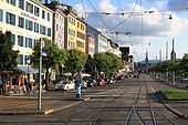
The Zürich tram lines 2, 4 and 15, as well as the Zürichsee-Schiffahrtsgesellschaft ZSG and its Limmat river tour boats provide public transportation towards Zürichhorn and Landesmuseum. Most private vehicles are prohibited; the area is the largest pedestrian zone of Zürich. Since 25 September 2004, the driving of motor vehicles, motorcycles and scooters is forbidden, except for goods transport, traffic towards Weinplatz, postal delivery services, and doctors and emergency services. Private road transport between Central and Brun bridge and Uraniastrasse (Urania Sternwarte) at the site of the former Oetenbach nunnery is still allowed,[2] as well as between the former upper Limmatquai and Bellevueplatz at the upper end of the Limmat river, as the road traffic via Utoquai and Rämistrasse still uses the Bellevue house area as a turning point towards General-Guisan-Quai.
Limmatquai and Utoquai project 'Riviera'
According to the project Riviera, the waterfront promenade between Utoquai, Quaibrücke and Limmatquai will be planted with two-row lines of Chestnut trees, and along the staircase to the Limmat river will be added a third detached tree row of Styphnolobium japonicum. The garden restaurant Terrasse will be redesigned, while the snack stand is maintained. Bus and motorized road transport operate in the future on a common track, meaning the separate bus lane at Utoquai is repealed, but on the river shore a bidirectional cycle path added.[3]
Name and origin
Around AD 1150 the term Lindemaga was for the first time mentioned for the Limmat river. In 1933, incidentally, the name Limmatquai was used for the right bank of the Limmat river; previously this term was applied only to the section of the former Marktststrasse or Altes Limmatquai; the upper (upstream) area was named Rathausquai around the former town hall (Rathaus) and Sonnenquai. The latter ranged from Bellevueplatz to the Grossmünsterplatz staircase, and was built between 1835 and 1839. Rathausquai ranged from the stairway built to the Grossmünster square downstream to the Marktgasse lane, and was built in 1835/36, at the same time as the Münsterbrücke. The 'old' Limmatquai was built in various stages since the 19th century, thus originating from the Niederdorf respectively Neumarkt area. In 1823/25 a narrow road was created between the former abattoir and Rosengasse, and was extended to Neumühlequai towards Central from 1855 to 1859. In the years 1887 to 1891 the whole street was broadened, and the Limmatquai assumed its present appearance.[4][5]
Trivia
The so-called Hafenkran or Zürich maritim, meaning on old crane from Dresden, three bollards installed before that will remain for a time, as well as a port horn localized on different high-rise buildings in Zürich. In general extremely polarized, the public and the political establishment of Zürich; so the costs for that provocation respectively art of about CHF 600,000 were paid by the government of Zürich, thus a local political of the Stadtrat (executive) claimed to have taken over about 10% of the costs by his own. Some progressive politicians paradoxly supported the project, otherwise the convervative political party as being the minority within executive authorities and parliament, even started an initiative not to install the construction; it was demolished between 19 and 28 January 2015 after nine months at Rathausbrücke–Limmatquai and definitely fit only for a knacker's yard. Nevertheless, the initiative was not yet handled by the Zürich parliament, another political novum in Zürich.[6] In fact, there was a small medieval harbour in the Limmat river – at present Schifflände square opposite of Bauschänzli towards Bellevue) and the former Grendeltor tower gate,[7] and even in Roman times, at Weinplatz also was just a transhipment port on the Zürich-Obersee route, where those larger dimensioned sailing ships were reload to the so-called Weidling river boats. So, for the last time, Zürich was a maritime area during the geological Tertiary period million years ago.
Literature
- Das Limmatquai vor und nach der Neugestaltung. Aufenthaltsnutzung, Fuss- und Veloverkehrsaufkommen im Vergleich der Jahre 2004-2005-2008. Published by Tiefbau- und Entsorgungsdepartement der Stadt Zürich, Zürich 2009.
References
- ↑ Grün Stadt Zürich (May 2006). "Vom Bürkliplatz zur Sukkulenten-Sammlung" (in German). Grün Stadt Zürich. Retrieved 2015-01-06.
- ↑ "Limmatquai" (in German). Polizeidepartement Stadt Zürich. Retrieved 2015-01-06.
- ↑ "Neugestaltung Utoquai und Limmatquai" (in German). Tiefbau- und Entsorgungsdeparement Stadt Zürich. 2013-06-13. Retrieved 2015-01-08.
- ↑ Gebrüder Dürst. "Limmatquai" (in German). alt-zueri.ch. Retrieved 2015-01-06.
- ↑ Gebrüder Dürst. "Central" (in German). alt-zueri.ch. Retrieved 2015-01-08.
- ↑ "Schweiz aktuell - Sendungen" (in German). Schweiz aktuell. 2015-01-19. Retrieved 2015-01-19.
- ↑ Gebrüder Dürst. "Das ehemalige Grendeltor" (in German). alt-zueri.ch. Retrieved 2015-01-05.
External links
| Wikimedia Commons has media related to Limmatquai. |