Limit Rock
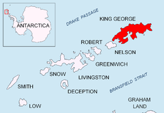
Location of King George Island in the South Shetland Islands.
Limit Rock (61°54′S 57°39′W / 61.900°S 57.650°WCoordinates: 61°54′S 57°39′W / 61.900°S 57.650°W) is a rock awash, lying 2 nautical miles (4 km) east of North Foreland, the northeast cape of King George Island, in the South Shetland Islands. It was charted in 1937 by Discovery Investigations personnel on the Discovery II, and so named because it marks the eastern limit of foul ground surrounding North Foreland.[1]
References
- ↑ "Limit Rock". Geographic Names Information System. United States Geological Survey. Retrieved 2013-06-15.
![]() This article incorporates public domain material from the United States Geological Survey document "Limit Rock" (content from the Geographic Names Information System).
This article incorporates public domain material from the United States Geological Survey document "Limit Rock" (content from the Geographic Names Information System).